The Satellite Blackout: How Private Space Firms Are Reshaping Conflict Transparency
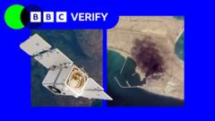
A major shift in the distribution of high-resolution satellite imagery has sparked a global debate over the influence of private space companies in active conflict zones. Planet Labs, a prominent California-based provider, has transitioned from temporary data delays to an indefinite, restricted distribution model covering Iran, Iraq, Israel, Lebanon, and Gaza. This policy change has effectively created a surveillance blackout, complicating the efforts of investigative journalists, regional analysts, and humanitarian organizations that rely on real-time intelligence to monitor developments on the ground.
While the company justifies the restriction as a security measure intended to prevent adversarial forces from accessing tactical data, critics suggest the move reflects a deeper entanglement between private corporate interests and government strategic goals. Given the company’s extensive contracts with the United States defense sector, observers are raising concerns that the policy serves state-level agendas rather than neutral security protocols. This development has blurred the lines between independent commercial enterprise and government-sanctioned information control.
The consequences for humanitarian aid are already becoming apparent. Organizations that depend on satellite surveillance to assess damage to critical infrastructure, such as water and sanitation systems, are struggling to coordinate relief efforts without reliable, high-resolution imagery. This information vacuum has created a fertile environment for misinformation and digital fabrications, which are increasingly difficult for the public to verify or debunk in the absence of objective, third-party satellite data.
Although some organizations are exploring alternative satellite providers, industry experts note that few competitors can match the daily revisit frequency and image clarity that have become the industry standard. As space-based surveillance technology continues to evolve, the tension between national security mandates and the necessity for global transparency is expected to intensify. This shift marks a pivotal moment in how private space firms navigate the complex intersection of geopolitical conflict and public accountability.
Key Takeaways
- Planet Labs has implemented an indefinite restriction on high-resolution satellite imagery for several Middle Eastern conflict zones.
- The policy has created an information vacuum that hinders humanitarian aid efforts and allows misinformation to proliferate.
- Critics argue the move highlights a growing trend of private space companies aligning their data policies with government defense interests.
Editor’s Analysis & Impact
The decision by a major commercial satellite provider to restrict data access in conflict zones represents a significant turning point for the ‘New Space’ economy. Historically, the democratization of satellite imagery empowered NGOs and journalists to hold state actors accountable. However, as these companies become increasingly reliant on government defense contracts, their role as neutral information providers is being compromised. This creates a dangerous precedent where the ‘truth’ on the ground is filtered through the lens of national security interests. Moving forward, we can expect increased regulatory scrutiny and a push for international standards regarding data access. If private firms continue to prioritize state-aligned security over transparency, the global community may see a rise in ‘sovereign’ satellite constellations funded by non-aligned nations to bypass these corporate-imposed blackouts.
Frequently Asked Questions
Q: Why are satellite companies restricting imagery in the Middle East?
A: The companies cite security concerns, arguing that high-resolution, real-time imagery could be used by adversarial forces to gain tactical advantages in conflict zones.
Q: How does this restriction affect humanitarian aid?
A: Aid organizations rely on satellite imagery to assess damage to infrastructure like hospitals and water systems. Without this data, they struggle to plan safe routes and prioritize relief efforts effectively.
AI Disclosure: This article is based on verified data and official reports. Our AI have cross-referenced every financial detail with primary sources to ensure total accuracy.
More from this Category