NASA Invites Global Participation in April 2026 Earth Observation Challenge
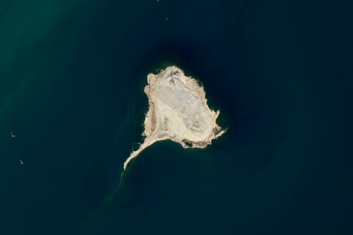
NASA has officially launched its latest monthly satellite imagery challenge, tasking the public with identifying a mysterious location captured from orbit. The April 2026 edition of the ‘Earth Puzzler’ series encourages geography enthusiasts and amateur scientists to analyze high-resolution aerial photography to pinpoint specific regions across the globe. These images often showcase a mix of natural wonders and human-influenced landscapes, providing a unique perspective on the planet’s evolving surface.
To participate, individuals must submit their findings through an official online portal. Beyond simply naming the location, the agency invites participants to provide a detailed breakdown of the visual evidence used to reach their conclusion. This includes identifying specific geological features, land-use patterns, or environmental markers that distinguish the area. The challenge is designed to promote critical thinking and a deeper understanding of how satellite data is interpreted by professionals in the field.
For those seeking a more rigorous academic exercise, the challenge also offers an opportunity to explore the technical side of remote sensing. Participants are encouraged to speculate on the specific satellite instruments used to capture the image and the spectral bands involved in the process. While the initiative does not offer financial compensation, it provides a platform for public recognition, with the first correct respondent receiving a public acknowledgment and their analysis potentially featured in the official follow-up report released one week after the initial launch.
Key Takeaways
- NASA's monthly 'Earth Puzzler' challenge invites the public to identify high-resolution satellite imagery of various global locations.
- Participants are encouraged to provide detailed analysis, including geological observations and technical insights into remote sensing instruments.
- The initiative serves as an educational tool to foster public interest in Earth science and satellite data interpretation.
Editor’s Analysis & Impact
The ‘Earth Puzzler’ initiative represents a strategic effort by NASA to democratize space-based data and foster a community of citizen scientists. By gamifying the interpretation of satellite imagery, the agency is effectively lowering the barrier to entry for complex Earth science concepts. From an industry perspective, this initiative highlights the growing accessibility of high-resolution remote sensing data, which is becoming increasingly vital for climate monitoring, urban planning, and environmental conservation. As satellite technology continues to advance, the ability for the general public to engage with and understand these visual datasets will be crucial for building support for future space missions. This program not only serves as a public relations success but also acts as a crowdsourced training ground for future researchers who may eventually contribute to professional geospatial analysis.
Frequently Asked Questions
Q: How can I participate in the NASA Earth Puzzler challenge?
A: You can participate by visiting the official NASA website, reviewing the monthly satellite image, and submitting your findings and reasoning through the dedicated online form.
Q: Are there prizes for winning the satellite image challenge?
A: There are no monetary prizes or physical rewards. Winners receive public acknowledgment from NASA, and their insights may be featured in the official follow-up explanation of the image.
AI Disclosure: This article is based on verified data and official reports. Our AI have cross-referenced every financial detail with primary sources to ensure total accuracy.
More from this Category