NASA Satellites Detect Unprecedented El Niño Event
NASA’s advanced satellite technology is providing crucial insights into a powerful El Niño event, which scientists are closely monitoring. This natural climate pattern, occurring approximately every two to seven years, is characterized by warmer-than-average sea surface temperatures in the equatorial Pacific Ocean. Current observations suggest this year’s El Niño could be one of the most significant on record, with an 83% probability of being the strongest since 1950, according to the National Oceanic and Atmospheric Administration (NOAA).
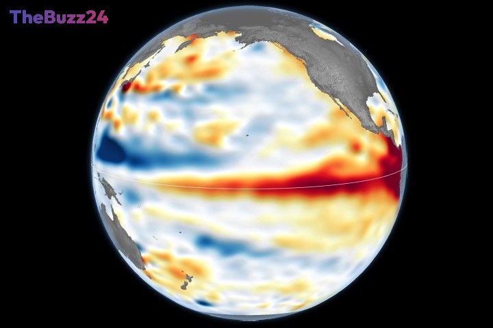
The phenomenon’s early indicators were detected in January 2026 through satellite imagery, which captured a massive swell of warm water known as a Kelvin wave moving eastward across the Pacific. These waves are instrumental in the El Niño cycle, transferring heat and altering atmospheric pressure, which in turn weakens or reverses the prevailing trade winds. This shift leads to a rise in sea levels in the eastern Pacific and further warming of ocean waters, a chain reaction that scientists can now track with unprecedented detail.
NASA’s Sentinel-6 satellites, equipped with sophisticated radar altimeters, are measuring ocean surface height with remarkable precision, tracking changes down to fractions of an inch. By April 2026, these Kelvin waves had reached the eastern Pacific, causing sea levels to rise by as much as 1.3 feet in some areas, while simultaneously dropping by up to 8 inches around Indonesia and northern Australia. Complementing this data, satellites equipped with microwave and infrared radiometers are measuring sea surface temperatures, revealing a band of significantly warmer water stretching across the Pacific. This warming directly influences global weather patterns by transferring heat and moisture into the atmosphere.
Further analysis from NASA’s PACE satellite is revealing subtle yet significant changes in ocean color. The warm waters associated with El Niño are causing a decrease in phytoplankton, microscopic marine plants that typically give the equatorial Pacific a greener hue. Phytoplankton thrive in cooler, nutrient-rich waters, and the reduced upwelling of deep-sea nutrients during El Niño limits their abundance. This decline has a ripple effect throughout the marine food web, potentially forcing marine life to seek new feeding grounds. The PACE satellite’s ability to observe ocean color in hyperspectral detail provides a new dimension to understanding the ecological impacts of El Niño.
Key Takeaways
- NASA satellites are closely monitoring a powerful El Niño event, potentially the strongest since 1950.
- Kelvin waves and changes in sea surface temperature and height are key indicators being tracked by satellites.
- El Niño is impacting ocean color by reducing phytoplankton, with potential cascading effects on marine ecosystems.
Editor’s Analysis & Impact
This El Niño event, amplified by advanced satellite observation capabilities, underscores the critical role of space-based monitoring in understanding Earth’s complex climate systems. The detailed data from missions like Sentinel-6 and PACE not only confirm the severity of the current El Niño but also provide invaluable insights into its far-reaching consequences, from altered weather patterns globally to significant disruptions in marine food webs. The ability to track subtle changes like ocean color offers a new frontier in climate science, enabling more accurate predictions and mitigation strategies. This event highlights the increasing importance of international collaboration and technological investment in climate research to address the challenges posed by such powerful natural phenomena.
Frequently Asked Questions
Q: What is El Niño?
A: El Niño is a natural climate pattern characterized by warmer-than-average sea surface temperatures in the central and eastern equatorial Pacific Ocean. It typically occurs every two to seven years and can significantly influence weather patterns worldwide.
Q: How do NASA satellites help monitor El Niño?
A: NASA satellites, such as Sentinel-6 and PACE, use instruments like radar altimeters and ocean color sensors to measure sea surface height, temperature, and the presence of phytoplankton. This data provides precise, large-scale observations of the ocean conditions associated with El Niño.
Q: What are the potential impacts of this strong El Niño?
A: A strong El Niño can lead to a wide range of impacts, including altered rainfall patterns (droughts in some regions, heavy rains in others), increased storm activity, and significant shifts in marine ecosystems due to changes in ocean temperature and nutrient availability.
AI Disclosure: This article is based on verified data and official reports. Our Team and AI have cross-referenced every financial detail with primary sources to ensure total accuracy.
More from this Category