The Caspian Sea’s Hidden Giants: Unveiling Azerbaijan’s Submerged Mud Volcanoes
While Azerbaijan is widely recognized for its surface-level natural gas seeps, a far more enigmatic geological landscape lies hidden beneath the waters of the Caspian Sea. The region serves as a global hotspot for mud volcanoes, with estimates suggesting that between 220 and 350 of these structures exist within the area. Unlike conventional volcanoes that discharge molten lava, these formations are driven by high-pressure sedimentary basins that force cold slurries of mud, water, and methane toward the surface.
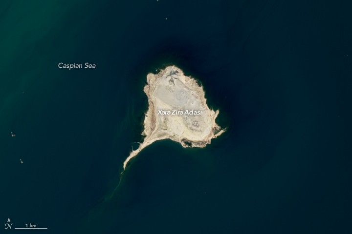
Of these structures, approximately 140 are located offshore, forming a distinct chain of islands within the Baku archipelago. These formations are easily identifiable from satellite imagery due to their unique ‘tadpole’ morphology. Geologists attribute this shape to the relentless action of sea currents, which continuously erode the soft, mud-based deposits that constitute the islands. Notable formations, such as Xərə Zirə Adası and Duvannı, serve as prime examples of how these environmental forces actively reshape the local geography over time.
Despite their appearance, these underwater structures are geologically active and capable of sudden, violent eruptions. Historical data confirms that islands like Səngi Muğan Adası have experienced intense paroxysmal events, including a significant 1932 eruption that resulted in a massive fireball. Because these volcanoes can drastically alter the landscape in a matter of minutes, they remain a focal point for researchers studying the tectonic shifts and the hydrocarbon-rich environment of the South Caspian Basin.
Key Takeaways
- Azerbaijan hosts hundreds of mud volcanoes, with at least 140 located offshore in the Caspian Sea.
- These volcanoes erupt with cold mud and methane, powered by high-pressure sedimentary basins rather than volcanic heat.
- Persistent sea currents are responsible for the distinct 'tadpole' shape of the islands in the Baku archipelago.
Editor’s Analysis & Impact
The geological activity within the South Caspian Sea represents a critical intersection between natural hazard research and energy exploration. Because these mud volcanoes are intrinsically linked to the region’s vast hydrocarbon reservoirs, they serve as natural indicators for geologists mapping potential oil and gas deposits. However, their inherent unpredictability presents significant challenges for maritime infrastructure and coastal development near the Baku archipelago. As satellite monitoring technology advances, the ability to track these formations in real-time will provide deeper insights into tectonic plate movements and the atmospheric release of methane. Ultimately, studying these volcanoes is essential for assessing regional seismic risks and understanding how sedimentary basins evolve under extreme pressure over geological timescales.
Frequently Asked Questions
Q: How do mud volcanoes differ from traditional volcanoes?
A: Traditional volcanoes erupt with molten lava and ash driven by mantle heat, whereas mud volcanoes erupt with a cold slurry of mud, water, and gases like methane, driven by high-pressure sedimentary layers.
Q: What causes the 'tadpole' shape of the islands in the Baku archipelago?
A: The elongated tails of these islands are formed by persistent sea currents that gradually erode the soft, mud-based material that composes the landmasses.
AI Disclosure: This article is based on verified data and official reports. Our AI have cross-referenced every financial detail with primary sources to ensure total accuracy.
More from this Category