The Precision Revolution: How Taiwan Maximizes Agricultural Output on Limited Land
Taiwan has established itself as a global benchmark for agricultural efficiency, generating an impressive $18 billion in annual output despite significant geographical limitations. With only a quarter of its 36,000 square kilometer territory suitable for cultivation, the island has successfully implemented intensive land management strategies to support a population of 23 million. This success is rooted in the strategic utilization of compact, highly productive plots that ensure every available inch of arable soil is optimized for maximum yield.
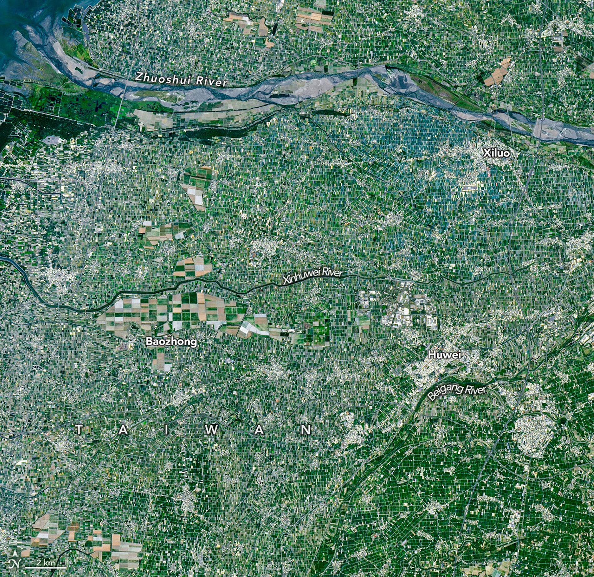
The Chianan Plain remains the epicenter of this agricultural success. In regions such as Yunlin County, farmers leverage narrow, canal-bordered strips of land to rotate a diverse array of crops, including traditional staples like rice, peanuts, and sweet potatoes, alongside high-value commodities like ornamental flowers and coffee. This region also functions as the primary hub for the nation’s livestock industry, particularly in pork production, demonstrating a sophisticated balance between diverse crop cultivation and animal husbandry.
Technological modernization is the primary driver sustaining this high level of output. While the landscape still bears the marks of historical land-use patterns, such as remnants of colonial-era sugar plantations, contemporary growers are rapidly integrating advanced infrastructure. In areas like Xiluo, the widespread adoption of shade-netting systems has revolutionized the agricultural landscape. These protective canopies shield crops from extreme weather and pests, facilitating year-round production and significantly higher yields. By blending historical land structures with modern climate-controlled technology, Taiwan continues to prove that dense, mountainous regions can achieve robust food security through persistent innovation.
Key Takeaways
- Taiwan generates $18 billion annually from agriculture despite having only 9,000 square kilometers of arable land.
- Farmers utilize intensive crop rotation and modern shade-netting technology to protect yields from climate and pest pressures.
- The agricultural sector successfully integrates historical land-use patterns with high-tech infrastructure to maintain food security.
Editor’s Analysis & Impact
Taiwan’s agricultural model offers a compelling blueprint for nations facing land scarcity and high population density. By prioritizing high-value crops and investing in protective infrastructure like shade-netting, the island has effectively decoupled agricultural output from land mass. This approach is increasingly relevant as global climate change threatens traditional farming regions, making ‘smart’ land use a critical component of national security. The integration of historical infrastructure with modern technology suggests that future agricultural growth will rely less on land expansion and more on yield optimization through precision farming. As global food demand rises, Taiwan’s ability to maintain a robust, self-sustaining agricultural economy serves as a scalable case study for other resource-constrained nations looking to enhance their domestic food production capabilities.
Frequently Asked Questions
Q: How does Taiwan manage to feed its population with such limited farmland?
A: Taiwan utilizes intensive land management, crop rotation, and advanced protective technologies like shade-netting to maximize the yield of every available plot of land.
Q: What role does technology play in modern Taiwanese farming?
A: Technology, particularly shade-netting systems, allows farmers to create controlled environments that protect crops from heat, rain, and pests, ensuring consistent production throughout the year.
AI Disclosure: This article is based on verified data and official reports. Our AI have cross-referenced every financial detail with primary sources to ensure total accuracy.
More from this Category