Curiosity Rover Captures Breathtaking 1.5-Billion-Pixel Panorama of Martian Landscape
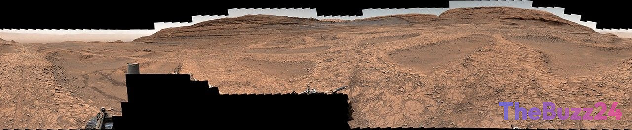
The Curiosity Mars rover has successfully documented a massive 1.5-billion-pixel panorama, delivering an unprecedented 360-degree perspective of a distinct geological region on the Red Planet. This high-resolution composite was assembled from 1,031 individual images captured by the rover’s Mastcam over a month-long period, spanning from November 9 to December 7, 2025. The resulting imagery offers scientists and the public alike a granular look at a landscape dominated by complex, ridge-like geological features known as boxwork formations.
While these structures often appear as vast, spiderweb-like patterns when viewed from orbital satellites, the new ground-level imagery clarifies their physical scale. The formations consist of low-lying ridges that reach heights of three to six feet and span approximately 30 feet across. The rover recorded this data at a site researchers have dubbed “Nevado Sajama,” a region where the robotic explorer recently performed drilling operations to extract geological samples for detailed laboratory analysis.
Since May 2025, Curiosity has been navigating this challenging terrain, which is defined by its intricate network of crisscrossing ridges and sandy depressions. The mission continues to yield vital data regarding the composition and history of the Martian surface. This latest panorama stands as one of the most expansive images ever produced by the rover, underscoring the continued operational success and scientific value of the long-running Mars exploration program.
Key Takeaways
- The Curiosity rover captured a 1.5-billion-pixel, 360-degree panorama of the 'Nevado Sajama' region on Mars.
- The imagery provides a detailed look at 'boxwork' formations, which are ridge-like structures measuring up to six feet in height.
- Curiosity has been actively drilling and collecting geological samples in this complex terrain since May 2025.
Editor’s Analysis & Impact
The successful capture of this high-resolution panorama highlights the enduring utility of the Curiosity rover, which remains a cornerstone of planetary science despite its age. By providing ground-level context to orbital observations, the mission bridges the gap between remote sensing and direct geological analysis. The study of boxwork formations is particularly significant, as these structures often indicate past fluid movement or mineral precipitation, offering clues into Mars’ ancient environmental history. As the rover continues to traverse the ‘Nevado Sajama’ site, the data collected from its drill samples will likely refine our understanding of Martian habitability. This mission demonstrates that even long-running robotic assets can continue to provide groundbreaking insights, setting the stage for future sample-return missions and human exploration efforts by mapping the most scientifically promising regions of the planet.
Frequently Asked Questions
Q: What are boxwork formations on Mars?
A: Boxwork formations are intricate, ridge-like geological structures that create a spiderweb-like pattern across the Martian surface, typically measuring several feet in height.
Q: How was the 1.5-billion-pixel panorama created?
A: The panorama was created by stitching together 1,031 individual high-resolution photographs taken by the Curiosity rover's Mastcam over the course of nearly a month.
AI Disclosure: This article is based on verified data and official reports. Our Team and AI have cross-referenced every financial detail with primary sources to ensure total accuracy.
More from this Category