Southern Georgia Faces Unprecedented Destruction as Wildfires Consume Over 120 Homes
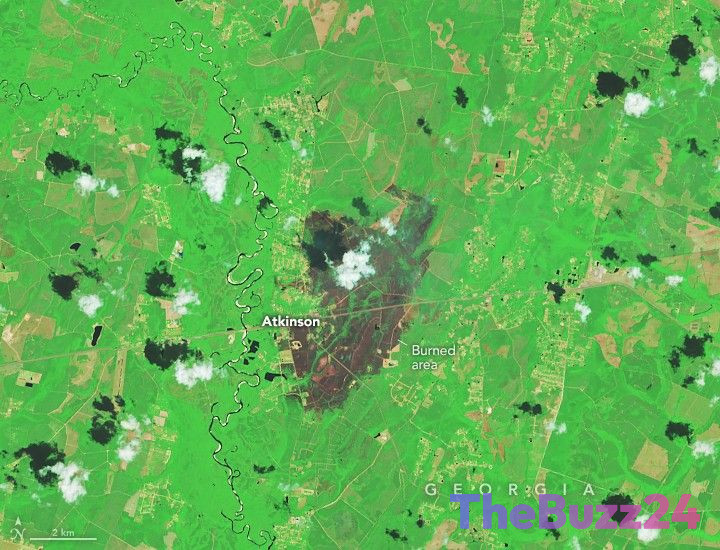
Southern Georgia is currently navigating a catastrophic emergency following two massive wildfires that have scorched more than 50,000 acres of land. The blazes, identified as the Pineland Road and Highway 82 fires, have resulted in the most significant residential property loss in the state’s history, with over 120 homes destroyed. The communities of Atkinson and Fruitland remain under a state of emergency as local authorities coordinate recovery and containment efforts.
The rapid spread of these fires was driven by a volatile mix of environmental factors. A prolonged, severe drought had left the regional landscape parched, while the accumulation of dry organic debris—left behind by Hurricane Helene in late 2024—provided a massive amount of fuel. When high winds moved through the area, the flames intensified, moving with a speed that overwhelmed initial containment efforts.
Investigations into the origins of the fires have confirmed that both were triggered by human activity. The Highway 82 fire was traced to a welding operation, while the Pineland Road fire was ignited when a mylar balloon made contact with overhead power lines. These incidents have brought renewed attention to the extreme vulnerability of the local ecosystem under current climatic pressures.
While recent rainfall has offered some respite to exhausted firefighting crews, containment remains a difficult task. As of late April, the Pineland Road fire was 23 percent contained, while the Highway 82 fire reached 32 percent containment. Hundreds of personnel are currently engaged in ground and aerial operations, as officials warn that the disaster serves as a sobering reminder of the heightened risks associated with drought-stricken, debris-laden environments.
Key Takeaways
- Over 50,000 acres have burned in Southern Georgia, resulting in the destruction of more than 120 homes.
- The fires were fueled by a combination of long-term drought and significant debris left over from Hurricane Helene.
- Official investigations determined that both fires were caused by human activity, specifically a welding accident and a mylar balloon incident.
Editor’s Analysis & Impact
The devastation in Southern Georgia highlights a critical challenge in modern disaster management: the compounding effect of climate-driven environmental stressors. By layering a prolonged drought over the lingering fuel loads from previous natural disasters like Hurricane Helene, the region created a ‘perfect storm’ scenario. This event underscores the urgent need for improved debris management and heightened public awareness regarding fire safety in vulnerable ecosystems. Moving forward, local governments will likely face increased pressure to implement stricter land-clearing regulations and public safety protocols to prevent human-caused ignitions. The economic and social impact on Atkinson and Fruitland will be long-lasting, necessitating a robust recovery strategy that addresses both immediate housing needs and long-term ecological restoration to mitigate future wildfire risks in an increasingly volatile climate.
Frequently Asked Questions
Q: What caused the wildfires in Southern Georgia?
A: The fires were caused by human activity: the Highway 82 fire was linked to a welding operation, and the Pineland Road fire was caused by a mylar balloon hitting power lines.
Q: Why were these fires so difficult to control?
A: The fires spread rapidly due to a combination of extreme drought conditions and a high volume of dry organic debris left over from Hurricane Helene, which acted as fuel for the flames.
AI Disclosure: This article is based on verified data and official reports. Our Team and AI have cross-referenced every financial detail with primary sources to ensure total accuracy.
More from this Category