San Francisco’s Urban Tapestry Unveiled from Orbit: An Astronaut’s Unique Perspective
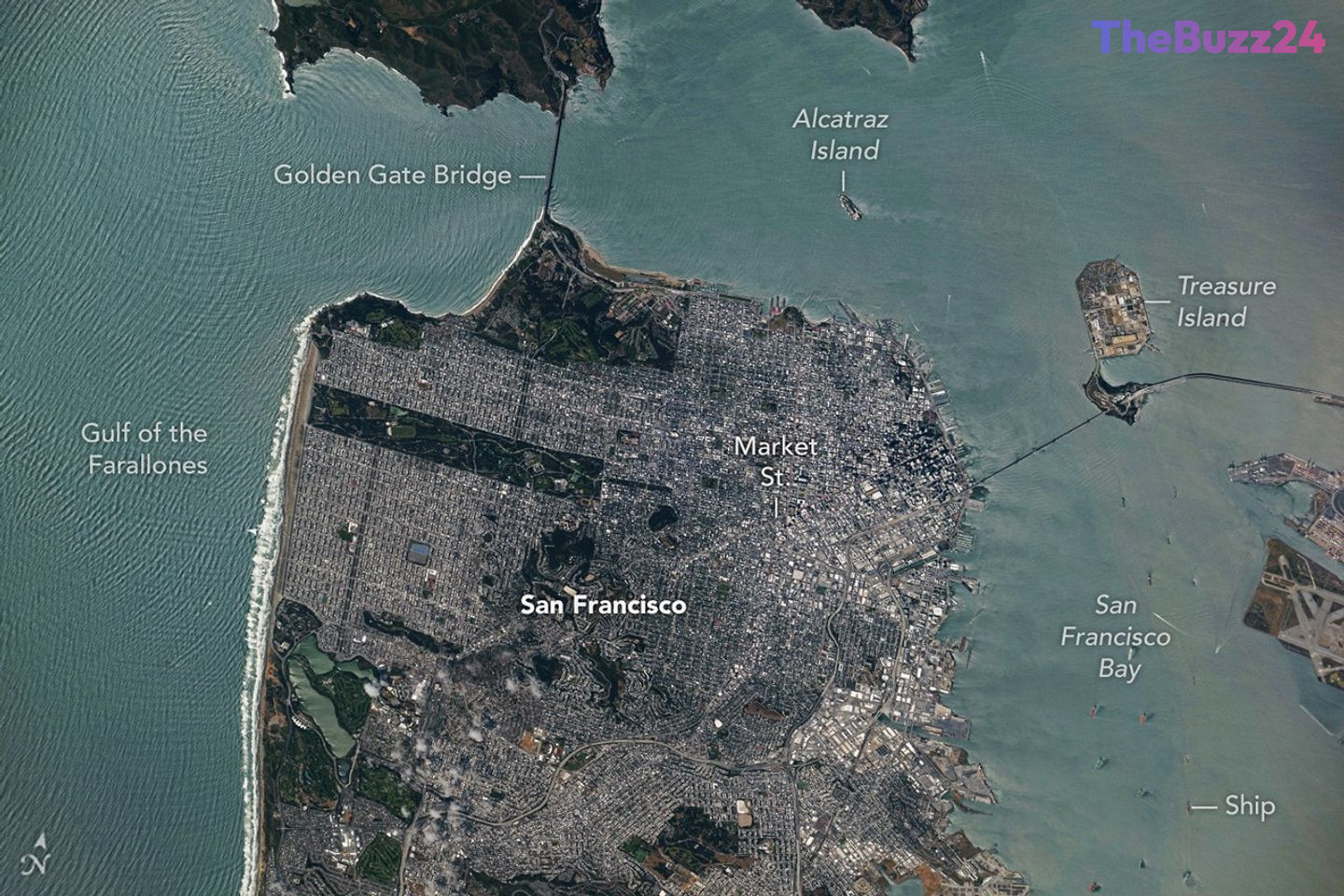
On May 27, 2026, an astronaut aboard the International Space Station (ISS) captured a stunning photograph of California’s San Francisco Bay Area. The image was taken during a brief respite in unsettled weather, revealing downtown San Francisco and its surrounding communities beneath largely cloud-free skies, offering a rare and detailed overhead view.
The orbital perspective vividly showcases two of the region’s most iconic architectural marvels: the Golden Gate Bridge, gracefully connecting the northern San Francisco Peninsula with Marin County, and the San Francisco-Oakland Bay Bridge, stretching across the bay towards Oakland to the east. Amidst the dense urban sprawl, Golden Gate Park emerges as a striking, elongated rectangle of verdant green. Spanning over 1,000 acres (400 hectares), this expansive park is a mosaic of meadows, gardens, wooded areas, and serene lakes, providing a vital ecological lung for the city. Further north, additional green spaces around the Golden Gate Bridge form part of a significant national recreation area.
The downward-looking vantage point also provides an unparalleled view of San Francisco’s intricate street grids, which were meticulously laid out over the city’s famously hilly terrain as it expanded through various stages of development. At the heart of the downtown area, Market Street stands out, running southwest to northeast and acting as a distinct boundary between two differing grid orientations—one aligned with the bay and the other with the street itself. Along the northeastern and eastern waterfront, a variety of structures, including historic wharves, seawalls, and piers, extend into the bay, many dating back to the early 1900s, with some even predating that era. These adjacent waters are bustling with heavy maritime traffic, accommodating cargo and container ships, cruise vessels, and regional ferries.
Along the western coast, breaking waves are clearly visible, particularly at Ocean Beach, a 3.5-mile stretch of sandy shore adjacent to Golden Gate Park. On the day the image was acquired, the National Weather Service had issued warnings of hazardous conditions at the region’s beaches. Strong northerly winds and long-period swells from the northwest contributed to an increased risk of rip currents and sneaker waves in the days following this remarkable capture.
Key Takeaways
- An astronaut on the International Space Station captured a detailed photograph of the San Francisco Bay Area on May 27, 2026, offering a unique overhead perspective.
- The image highlights iconic landmarks such as the Golden Gate Bridge, San Francisco-Oakland Bay Bridge, and the expansive Golden Gate Park, contrasting green spaces with urban development.
- The photograph also reveals intricate urban planning, historic waterfronts, active maritime traffic, and coastal features, alongside recent weather warnings for hazardous beach conditions.
Editor’s Analysis & Impact
This unique perspective of San Francisco from the International Space Station underscores the critical value of orbital observation platforms. Such high-resolution imagery provides invaluable data for urban planners, environmental scientists, and maritime authorities, enabling them to monitor urban growth, assess green infrastructure, track coastal changes, and even observe localized weather phenomena from a macro scale. In an era of rapid urbanization and climate change, these insights are crucial for informed decision-making, sustainable development, and disaster preparedness. The continuous stream of data from space helps us understand the complex interplay between human activity and natural environments, offering a powerful tool for managing our planet’s resources and mitigating future risks.
Frequently Asked Questions
Q: What is the significance of photographs taken from the International Space Station?
A: Photographs from the ISS provide a unique, high-altitude perspective of Earth, offering valuable insights into urban development, geographical features, environmental changes, and weather patterns that are difficult to observe from ground level. They are crucial for scientific research and public understanding of our planet.
Q: Which iconic San Francisco landmarks are prominently visible in the astronaut's photograph?
A: The photograph clearly showcases the Golden Gate Bridge, the San Francisco-Oakland Bay Bridge, and the expansive green area of Golden Gate Park, among other significant urban and natural features of the Bay Area.
Q: What weather conditions were noted around the time the image was captured?
A: The image was taken during a break in unsettled weather, allowing for clear skies over downtown San Francisco. However, the National Weather Service had issued warnings for hazardous beach conditions due to strong northerly winds and long-period swells, increasing the risk of rip currents and sneaker waves.
AI Disclosure: This article is based on verified data and official reports. Our Team and AI have cross-referenced every financial detail with primary sources to ensure total accuracy.
More from this Category