Severe Thunderstorms Illuminate UK Skies Following Record Heat
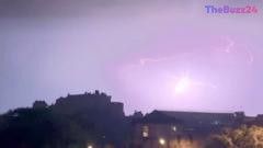
The United Kingdom experienced a dramatic shift in weather conditions during the early hours of Friday as intense heat triggered widespread thunderstorm activity. Residents across the country captured footage of vivid lightning strikes illuminating the night sky, with notable displays recorded over iconic landmarks such as Edinburgh Castle, as well as across major urban centers including Bristol and Manchester.
The volatile weather system extended its reach beyond England, impacting regions throughout Northern Ireland and Wales. These atmospheric disturbances followed a period of extreme temperatures, highlighting the volatile nature of the current climate pattern affecting the British Isles.
Looking ahead, meteorological forecasts suggest that the oppressive heat is set to subside over the coming weekend. However, authorities remain cautious, having issued a yellow weather warning for thunderstorms covering Scotland and various parts of northern England. Residents in these areas are advised to stay informed as the weather front continues to move across the region.
Key Takeaways
- Intense heat across the UK triggered significant thunderstorm activity and widespread lightning strikes early Friday.
- Major cities and landmarks, including Edinburgh Castle, Bristol, and Manchester, were impacted by the storm front.
- A yellow weather warning remains in effect for Scotland and northern England as the heatwave begins to dissipate.
Editor’s Analysis & Impact
The recent surge in extreme weather events across the UK underscores the increasing frequency of heat-induced atmospheric instability. From a meteorological perspective, the transition from record-breaking heat to severe thunderstorms is a classic indicator of a high-energy environment, where rapid cooling meets residual thermal mass. For the broader public and infrastructure sectors, these events highlight the growing necessity for robust emergency management and climate-resilient urban planning. As these patterns become more frequent, the economic impact—ranging from potential power grid strain to agricultural disruption—will likely necessitate more sophisticated early-warning systems. The future outlook suggests that the UK must prepare for a ‘new normal’ where rapid, high-impact weather shifts become a standard feature of the summer season, requiring both policy adjustments and increased public awareness regarding severe weather safety.
Frequently Asked Questions
Q: Why did the thunderstorms occur after the heatwave?
A: Thunderstorms often follow intense heat because the high temperatures cause moisture to rise rapidly into the atmosphere, where it cools and condenses to form storm clouds, resulting in electrical discharges.
Q: What does a yellow weather warning mean for residents?
A: A yellow warning indicates that while the weather is unlikely to cause widespread disruption, residents should remain aware of potential localized issues such as travel delays, power outages, or minor flooding.
AI Disclosure: This article is based on verified data and official reports. Our Team and AI have cross-referenced every financial detail with primary sources to ensure total accuracy.
More from this Category