UN General Assembly Votes to Adopt New World Map to Correct Africa’s Scale
The United Nations General Assembly has officially voted to move away from the traditional Mercator projection, adopting a new world map designed to more accurately reflect the true size of the African continent. The resolution, titled ‘Correct the Map,’ received overwhelming support from 164 nations, including major powers like France and the United Kingdom. While the vote is non-binding, it marks a significant shift in how international institutions will visualize global geography moving forward.
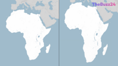
For centuries, the Mercator projection—created in 1569 for maritime navigation—has been the global standard. However, critics have long argued that the map significantly distorts the size of landmasses, particularly those near the equator. Under the Mercator model, Africa appears roughly the same size as Greenland, despite being approximately 14 times larger in reality. Proponents of the change argue that this visual distortion has historically minimized the perceived scale, resources, and economic potential of African nations.
The initiative, spearheaded by Togo and supported by the African Union, advocates for the use of the ‘Equal Earth’ projection, which was developed by cartographers in 2018 to provide a more balanced representation of all continents. Supporters of the resolution emphasize that maps are not neutral tools; they shape political and economic perceptions. By adopting a more accurate representation, the international community aims to address what many describe as a long-standing narrative issue that has influenced global understanding of Africa’s place in the world.
Despite the broad international consensus, the United States stood as the sole dissenting vote, with six other nations abstaining. The U.S. delegation expressed concerns that the assembly was prioritizing symbolic cartographic debates over more pressing issues of international peace and prosperity. Nevertheless, the move is being hailed by activists and geographers as a vital step toward ‘cognitive justice,’ ensuring that the visual representation of the world aligns more closely with physical reality.
Key Takeaways
- The UN General Assembly passed a non-binding resolution to replace the Mercator map with the more accurate 'Equal Earth' projection.
- The Mercator projection has been criticized for decades for distorting the size of Africa, making it appear significantly smaller than it is relative to northern landmasses.
- The U.S. was the only nation to vote against the resolution, arguing that the UN should focus on contemporary geopolitical challenges rather than historical cartography.
Editor’s Analysis & Impact
The UN’s decision to adopt a new world map is a symbolic yet powerful shift in global discourse. By addressing the ‘Mercator bias,’ the international community is acknowledging that cartography is inherently political. From a market perspective, this change could subtly influence how global investors and policymakers perceive the scale of African markets, potentially shifting the focus toward the continent’s vast landmass and resource density. While the move is non-binding, its adoption by major institutions will likely lead to a gradual phasing out of the Mercator projection in educational and governmental materials. The broader implication is a move toward ‘cognitive justice,’ where the visual framing of the Global South is corrected to reflect its true geopolitical weight, potentially fostering more equitable economic and diplomatic engagement in the coming decades.
Frequently Asked Questions
Q: Why is the Mercator map considered inaccurate?
A: The Mercator projection is a cylindrical map projection that distorts the size of objects as the latitude increases from the equator to the poles. This makes landmasses near the equator, like Africa, appear much smaller than they actually are compared to countries in the northern hemisphere.
Q: What is the 'Equal Earth' projection?
A: The Equal Earth projection is a map design introduced in 2018 that maintains the relative size of landmasses, providing a more accurate visual representation of the world's continents compared to the traditional Mercator map.
AI Disclosure: This article is based on verified data and official reports. Our Team and AI have cross-referenced every financial detail with primary sources to ensure total accuracy.
More from this Category