Orbital Perspective: Capturing the Ancient Geological Evolution of Canada’s James Bay
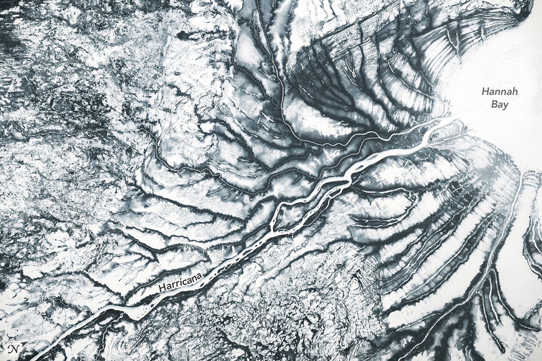
In late March 2026, an astronaut stationed aboard the International Space Station documented a remarkable view of the frozen terrain surrounding Hannah Bay, located at the southern tip of Canada’s James Bay. The imagery captures a landscape still firmly gripped by winter, where sea ice remains anchored to the coastline and the expansive, boggy lowlands are blanketed in snow. This vantage point offers a rare look at the boreal topography, highlighting complex patterns shaped by centuries of geological transformation.
Prominent ridges visible near the Harricana River serve as physical evidence of glacial isostatic adjustment. This ongoing geological process began following the retreat of the Laurentide Ice Sheet roughly 20,000 years ago. As the immense pressure of the ancient ice dissipated, the earth began a slow, steady rebound, rising at a rate of approximately 10 millimeters annually. These distinct beach ridges act as a historical record, tracing the shifting shoreline as water levels have receded over millennia.
Beyond its geological history, the region contains one of the most significant peatland complexes on the planet. These muskeg bogs function as critical carbon sinks, serving as a vital component of the global climate regulatory system. As the seasons shift, the landscape undergoes a dramatic metamorphosis; the frozen, monochromatic expanse gives way to lush greenery, while organic tannins leach into the waterways, turning them a characteristic deep brown. The annual breakup of sea ice, which typically commences in May, signals the start of this rapid ecological transition.
Key Takeaways
- Astronauts captured high-resolution imagery of the frozen James Bay Lowlands, revealing ancient geological patterns.
- The region's unique ridge formations are caused by glacial isostatic adjustment, with the land still rising 10mm per year following the last ice age.
- The James Bay peatlands are globally significant carbon sinks that undergo a massive visual and ecological transformation during the spring thaw.
Editor’s Analysis & Impact
The documentation of the James Bay Lowlands from space underscores the critical intersection between geological history and modern climate science. By observing these peatlands, researchers gain better insights into how carbon-dense ecosystems react to seasonal shifts and long-term environmental changes. The ongoing glacial rebound in this region provides a living laboratory for geologists to study crustal movement, while the peatlands’ role as a carbon sink makes them a focal point for climate change mitigation strategies. As global temperatures fluctuate, the stability of these northern wetlands becomes increasingly important. The ability to monitor these remote areas from orbit allows for a more comprehensive understanding of how boreal landscapes contribute to global carbon sequestration, ultimately informing future conservation policies and climate modeling efforts.
Frequently Asked Questions
Q: What causes the ridges seen in the James Bay Lowlands?
A: The ridges are caused by glacial isostatic adjustment, a process where the land slowly rises after being relieved of the immense weight of ancient ice sheets that retreated thousands of years ago.
Q: Why are the peatlands in this region important?
A: These peatlands are vital because they act as massive carbon sinks, helping to regulate the global climate by storing significant amounts of carbon within their organic matter.
AI Disclosure: This article is based on verified data and official reports. Our AI have cross-referenced every financial detail with primary sources to ensure total accuracy.
More from this Category