Pacific Storm Surge: Satellite Imagery Captures Rare Triple Cyclone Event
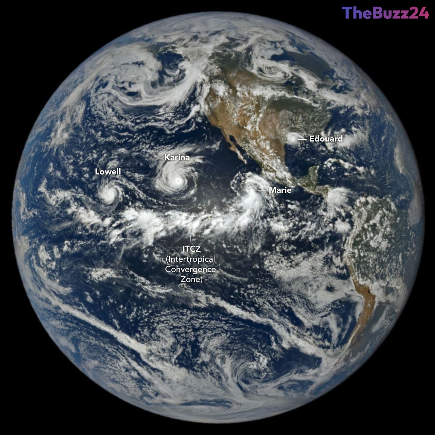
The 2026 hurricane season has reached a dramatic peak, with satellite imagery capturing a rare meteorological phenomenon in the Pacific Ocean. As of early September, the Northeast Pacific basin has experienced an unusually high level of activity, featuring a trio of tropical cyclones—Lowell, Karina, and Marie—churning simultaneously. This surge in activity aligns with seasonal forecasts that predicted a more intense Pacific season driven by the influence of El Niño.
Data from the Deep Space Climate Observatory (DSCOVR) satellite provided a unique perspective of the storms from nearly one million miles away. Among the trio, Lowell intensified into a Category 5 hurricane, while Karina reached Category 4 status, marking a rare occurrence of two major hurricanes spinning in the same region at once. Meanwhile, Marie continued to strengthen as it tracked northwest of Baja California. These systems highlight the significant impact of warmer ocean temperatures in the Pacific, which have fueled storm development throughout the season.
In contrast, the Atlantic basin has remained notably quiet, hampered by unfavorable wind shear conditions. While the Pacific has seen activity levels 50 percent above normal, the Atlantic has struggled to sustain major storm systems. Despite this, the region was not without impact; Tropical Storm Edouard recently made landfall in Louisiana and Texas, bringing torrential rainfall and significant infrastructure damage to the Gulf Coast. Meteorologists continue to monitor these contrasting basins as the hurricane season progresses, utilizing advanced satellite data to track storm intensity and longevity.
Key Takeaways
- The 2026 hurricane season is characterized by a stark contrast between an hyper-active Pacific basin and a suppressed Atlantic basin due to El Niño.
- Satellite imagery captured a rare simultaneous occurrence of three tropical cyclones in the Pacific, including a Category 5 and a Category 4 storm.
- While the Atlantic has seen fewer storms, Tropical Storm Edouard caused significant flooding and damage in the U.S. Gulf Coast region.
Editor’s Analysis & Impact
The 2026 hurricane season serves as a textbook example of how large-scale climate drivers like El Niño dictate global weather patterns. By warming the waters of the eastern and central Pacific while simultaneously increasing wind shear in the Atlantic, El Niño creates a ‘seesaw’ effect in tropical cyclone activity. From an industry perspective, this highlights the growing importance of satellite-based monitoring and predictive modeling for disaster preparedness. As climate volatility increases, the ability to accurately forecast these basin-specific shifts is critical for insurance markets, supply chain logistics, and emergency management agencies. The rarity of simultaneous major hurricanes in the Pacific underscores the need for robust, real-time data infrastructure to mitigate the economic and humanitarian risks associated with increasingly intense weather events.
Frequently Asked Questions
Q: Why is the Pacific experiencing more hurricanes than the Atlantic this season?
A: The current El Niño event is warming Pacific waters and shifting atmospheric circulation patterns, which promotes storm formation in the Pacific while creating unfavorable wind shear conditions that suppress storm development in the Atlantic.
Q: What is the ACE index mentioned in the report?
A: The Accumulated Cyclone Energy (ACE) index is a metric used by meteorologists to measure the total energy and longevity of tropical cyclones throughout a season, allowing for a more accurate comparison of storm activity between different years and basins.
AI Disclosure: This article is based on verified data and official reports. Our Team and AI have cross-referenced every financial detail with primary sources to ensure total accuracy.
More from this Category