Unprecedented El Niño Climate Phenomenon Reaches Record Intensity Ahead of Peak
The unfolding El Niño climate cycle has officially surpassed historical measurements, establishing itself as the most powerful event on record weeks ahead of its anticipated seasonal peak. Experts tracking Pacific Ocean temperatures recorded daily sea surface anomalies in the central-eastern Pacific that outpaced previous historic benchmarks, signaling a potent phase of global weather disruption.
El Niño is a naturally occurring climatic pattern characterized by the weakening or reversal of standard trade winds across the Pacific Ocean. This shift allows warm water to accumulate eastward, releasing significant thermal energy into the atmosphere. While individual metrics vary depending on whether scientists evaluate absolute sea surface temperatures or relative ocean warmth factoring in background climate change, the overarching trend points to an exceptionally robust cycle.
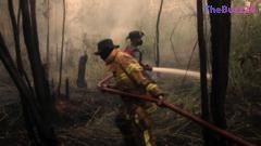
Global consequences of the phenomenon are already materializing across multiple continents. Environmental stress has triggered severe wildfires impacting millions of residents in Indonesia, while diminished monsoon rainfall has been documented in India. Conversely, altered atmospheric wind patterns have contributed to a delayed Atlantic hurricane season, alongside heightened risks of torrential rainfall and flooding in parts of South America and the southern United States. Agriculture, regional economies, and food security remain acutely vulnerable to these shifting meteorological conditions as the cycle progresses.
Although the tropical Pacific is thousands of miles away from north-west Europe, historical patterns suggest that severe El Niño phases can influence regional climates. Forecasters indicate an increased probability of wet and stormy conditions heading into the late autumn and early winter months. As meteorologists continue to observe this record-breaking climatic event, communities worldwide are bracing for further anomalies as the phenomenon approaches its peak.
Key Takeaways
- Daily sea surface temperatures in the central-eastern Pacific have surpassed previous records set during the 2015 El Niño event.
- Global impacts are already evident, including reduced monsoon rainfall in India, delayed Atlantic hurricane activity, and severe wildfires in Indonesia.
- Meteorologists anticipate the current El Niño cycle will reach its official peak later this year, potentially bringing stormy weather to north-west Europe.
Editor’s Analysis & Impact
The emergence of a record-setting El Niño carries profound implications for global supply chains, agricultural commodities, and macroeconomic stability. Historically, extreme weather anomalies driven by this climatic cycle disrupt crop yields in key agricultural regions across Asia and South America, subsequently driving up food prices and exacerbating inflationary pressures. Furthermore, energy sectors face volatility as unseasonal temperatures alter heating and cooling demands worldwide. While the full economic fallout depends heavily on the intensity and duration of the weather patterns in the coming months, industries ranging from insurance to logistics must factor these heightened environmental risks into their long-term forecasting and risk-management strategies.
Frequently Asked Questions
Q: What is an El Niño event?
A: El Niño is a naturally occurring climate pattern where trade winds across the Pacific Ocean weaken or reverse, allowing warm water to spread eastward and release heat into the atmosphere, significantly altering global weather.
Q: How is the strength of an El Niño measured?
A: Scientists track El Niño using daily sea surface temperatures in a key region of the Pacific Ocean, often utilizing metrics like the Oceanic Niño Index (ONI) or the Relative Oceanic Niño Index (RONI) to gauge abnormal warmth.
Q: What are the typical global impacts of a strong El Niño?
A: Common impacts include droughts and wildfires in regions like Indonesia and Australia, reduced monsoon rainfall in India, altered hurricane activity, and increased flood risks in parts of South America and the southern United States.
AI Disclosure: This article is based on verified data and official reports. Our Team and AI have cross-referenced every financial detail with primary sources to ensure total accuracy.
More from this Category