Mapping the Unseen: Advanced Satellite Techniques Reveal Hidden Valleys Beneath Greenland’s Ice Sheet
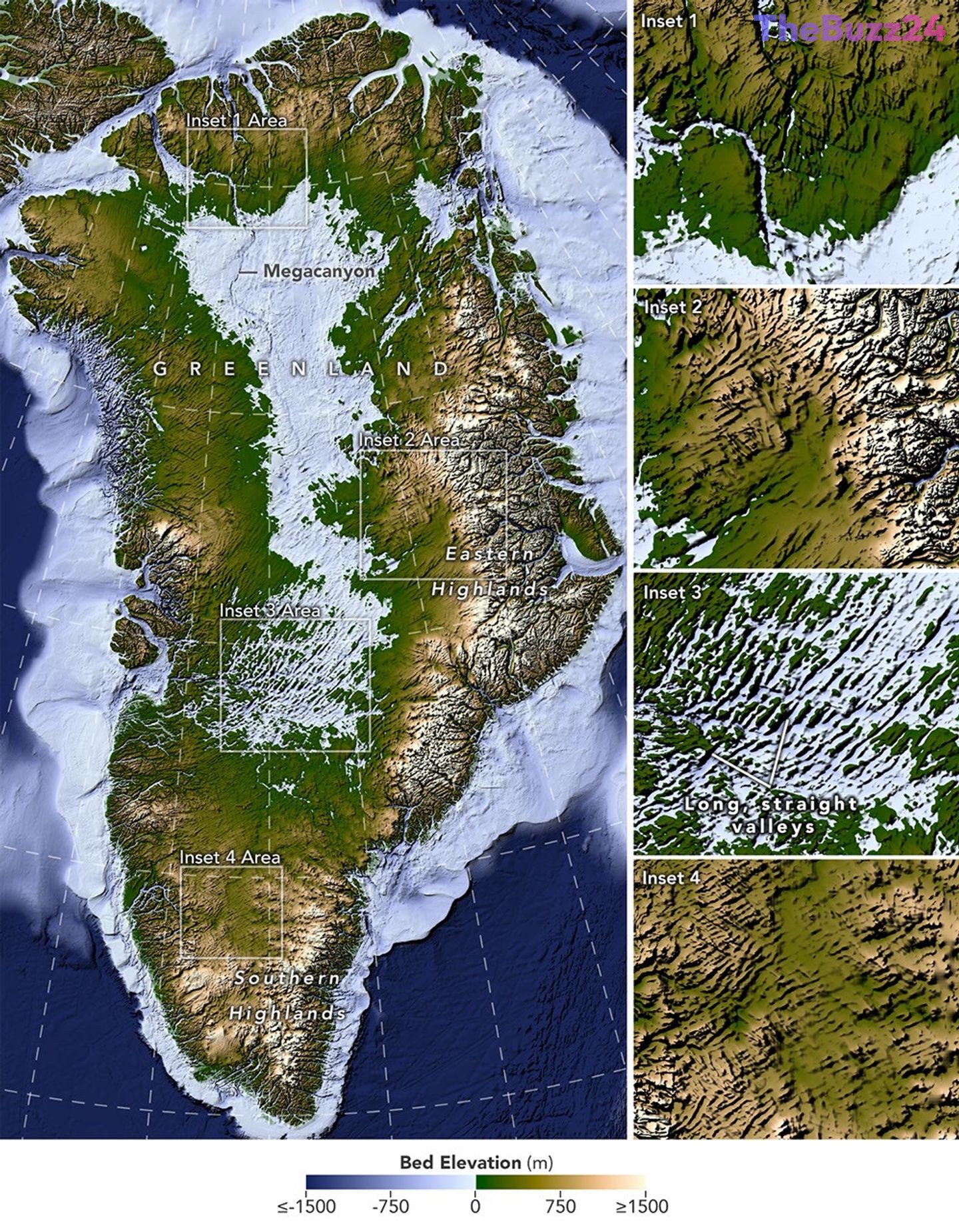
A groundbreaking method for mapping the bedrock hidden deep beneath Greenland’s colossal ice sheet has provided researchers with an unprecedented view of the island’s pre-glacial landscape. Encompassing over 1.7 million square kilometers and reaching depths exceeding three kilometers, Greenland has long guarded the secrets of its underlying terrain. However, leveraging high-resolution satellite observations and an innovative technique known as Ice Flow Perturbation Analysis, scientists have managed to map a vast, intricate network of subglacial valleys that have never been directly witnessed by human eyes.
As immense quantities of glacial ice traverse uneven terrain, subtle signatures are left etched onto the surface. By meticulously tracking these microscopic bumps and depressions from orbit, researchers can accurately infer the complex geometry of the hidden geography below. This advanced mapping effort has successfully identified nearly 2,000 subglacial valleys, roughly a third of which are entirely new discoveries. Furthermore, many previously documented features have now been traced hundreds of kilometers further inland than earlier models suggested, fundamentally updating our understanding of Greenland’s deep topography.
The newly revealed landscape presents a fascinating mixture of familiar geological formations and perplexing anomalies. Near the eastern highlands, ancient alpine-style mountain ranges and interconnected valleys appear to have remained remarkably preserved beneath the frozen blanket since the Pliocene epoch. Conversely, the west-central region exhibits a series of unnaturally long, straight valleys aligned in a uniform southwest-northeast trajectory. This alignment hints at underlying tectonic forces and ancient groundwater networks that actively carved the rock long before the modern ice sheet ever formed.
Comprehending this hidden topography is critical for forecasting how the Greenland Ice Sheet will respond to a warming climate. Because glacial ice naturally funnels through low-lying channels, understanding the exact placement and structure of these valleys allows researchers to model future ice retreat with greater accuracy. As glaciers accelerate through these corridors, they dynamically reshape the landscape beneath them, creating a continuous cycle of erosion. With these refined maps, scientists are now better equipped to predict how faster ice flows will propagate into Greenland’s interior in the decades and centuries to come.
Key Takeaways
- Researchers have mapped nearly 2,000 subglacial valleys beneath the Greenland Ice Sheet using an innovative satellite technique called Ice Flow Perturbation Analysis.
- About a third of the mapped valleys are entirely new discoveries, while others extend hundreds of kilometers further inland than previous models indicated.
- Analyzing the bedrock topography helps scientists improve long-term models predicting how the ice sheet will retreat and shift as the climate changes.
Editor’s Analysis & Impact
The deployment of Ice Flow Perturbation Analysis marks a significant milestone in cryospheric science, bridging the gap between satellite remote sensing and deep geological exploration. As climate pressures continue to accelerate polar ice loss, accurate models of bedrock topography are vital. Understanding the precise pathways through which ice flows will allow climatologists to drastically improve sea-level rise projections. Beyond immediate climate applications, these findings open new avenues for understanding ancient tectonic and hydrological processes that shaped the Arctic long before human history. The integration of advanced orbital data with traditional geological mapping sets a new standard for Earth observation.
Frequently Asked Questions
Q: How do scientists map bedrock hidden beneath miles of ice?
A: Scientists use Ice Flow Perturbation Analysis, a method that examines faint signatures and subtle bumps left on the surface of the ice sheet by underlying topography, utilizing high-resolution satellite data.
Q: Why are these subglacial valleys important to study?
A: Ice naturally flows and accelerates through valleys. Understanding the layout of these subterranean channels helps scientists predict how glaciers will move and retreat as the climate changes.
Q: What surprising feature was found beneath the western region of Greenland?
A: Researchers discovered long, straight valleys aligned in a consistent southwest-northeast direction, suggesting unique tectonic influences and ancient groundwater activity before the ice sheet formed.
AI Disclosure: This article is based on verified data and official reports. Our Team and AI have cross-referenced every financial detail with primary sources to ensure total accuracy.
More from this Category