The Volcanic Power and Peril of El Salvador’s Ahuachapán Region
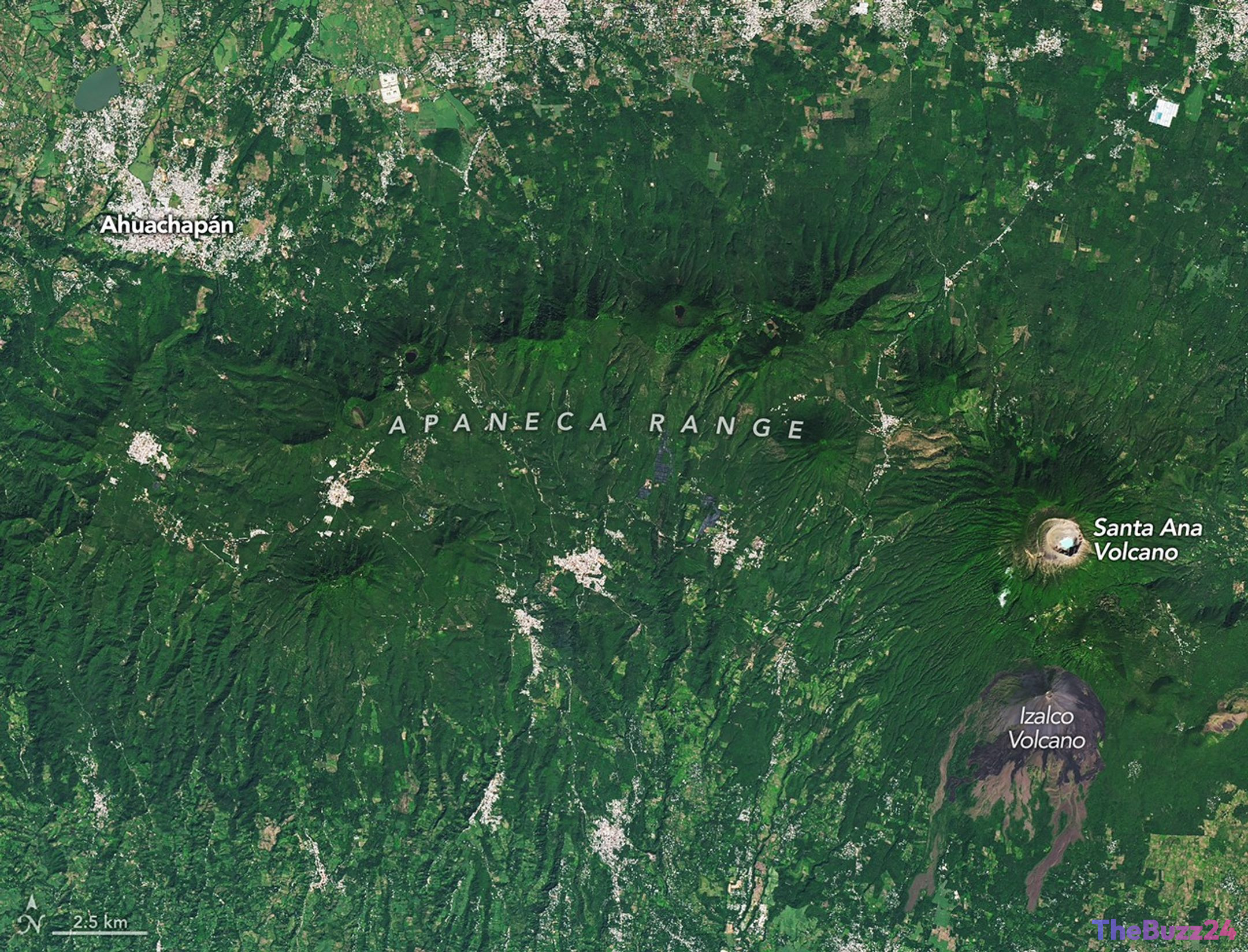
The landscape surrounding Ahuachapán, El Salvador, serves as a vivid reminder of the Earth’s volatile nature. Situated along the Central American Volcanic Arc—a 1,000-kilometer chain of volcanoes stretching from Guatemala to Panama—this region is defined by a complex interplay of geological activity. Recent satellite imagery highlights a terrain pockmarked by craters and lava flows, where the raw power of the planet is harnessed for energy and occasionally poses significant risks to local infrastructure.
Dominating the skyline is Santa Ana, El Salvador’s tallest volcano, which reaches 2,381 meters above sea level. Known for its crescent-shaped ridges and acidic crater lake, the volcano has remained active for centuries, with its most notable recent eruption occurring in 2005. Nearby, the stratovolcano Izalco, once dubbed the “Lighthouse of the Pacific” for its frequent, glowing eruptions, has remained dormant since 1966. Meanwhile, the Apaneca Range, while lacking recent volcanic eruptions, continues to exhibit persistent geothermal activity, including fumaroles and steam vents that have triggered sudden, localized explosions.
Despite these hazards, the region has become a cornerstone of El Salvador’s energy independence. The Ahuachapán Geothermal Power Plant, operational since 1975, utilizes groundwater heated to 250 degrees Celsius by the underlying volcanic fault systems. This facility has historically provided a substantial portion of the nation’s electricity, demonstrating how the same forces that create geological instability can be effectively repurposed to support modern industrial and population growth.
However, the risks remain present. Recent years have seen steam eruptions near popular geothermal sites, leading to infrastructure damage and necessary evacuations. As the region continues to develop, the balance between leveraging geothermal energy and managing the inherent dangers of living within an active volcanic arc remains a critical challenge for local authorities and residents alike.
Key Takeaways
- The Ahuachapán region is part of the Central American Volcanic Arc, a highly active geological zone featuring both dormant and active volcanoes.
- The Ahuachapán Geothermal Power Plant has been a vital source of electricity for El Salvador since 1975, utilizing natural heat from volcanic fault systems.
- While geothermal energy provides significant benefits, the region faces ongoing risks from steam explosions and volcanic activity, necessitating careful monitoring and emergency planning.
Editor’s Analysis & Impact
The Ahuachapán region represents a classic case study in the dual nature of volcanic geography: it is simultaneously a source of sustainable energy and a site of persistent environmental risk. From a market perspective, the reliance on geothermal power is a strategic asset for El Salvador, providing a stable, renewable energy base that reduces dependence on imported fossil fuels. However, the industry faces a ‘geological risk premium’ where infrastructure investments must account for the potential of sudden steam eruptions and seismic activity. Future development in the region will likely require advanced monitoring technologies to mitigate these hazards. As global interest in renewable energy grows, the success and operational longevity of the Ahuachapán plant serve as a model for other nations situated along volcanic arcs to transition toward geothermal independence while navigating the complexities of living in high-risk zones.
Frequently Asked Questions
Q: What is the Central American Volcanic Arc?
A: It is a chain of volcanoes that stretches more than 1,000 kilometers along the Pacific coast of Central America, running from Guatemala through to Panama.
Q: How does the Ahuachapán Geothermal Power Plant generate electricity?
A: The plant leverages groundwater that is naturally heated to approximately 250 degrees Celsius (480 degrees Fahrenheit) by the region's volcanic fault systems to produce steam for power generation.
Q: Is the Apaneca Range currently active?
A: While there have been no recorded volcanic eruptions in the Apaneca Range during the Holocene epoch, it remains geothermally active, frequently producing fumaroles, hot springs, and occasional dangerous steam explosions.
AI Disclosure: This article is based on verified data and official reports. Our Team and AI have cross-referenced every financial detail with primary sources to ensure total accuracy.
More from this Category