Antarctic Volcano Revealed: Mount Michael’s Persistent Lava Lake Captured from Space
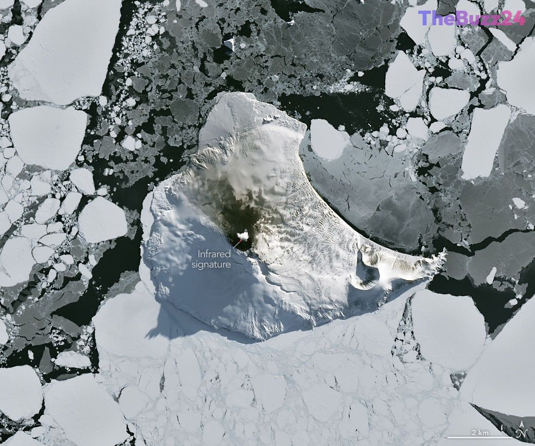
Deep within the frozen expanse of the South Atlantic, the remote Mount Michael stratovolcano on Saunders Island continues to defy the harsh Antarctic winter. Recent satellite imagery has provided a rare, cloud-free glimpse of the peak, revealing that the volcano remains geologically active despite the surrounding sea ice and freezing temperatures. Infrared data captured in late August 2026 clearly highlights a persistent heat signature within the summit crater, confirming the presence of an active lava lake.
Mount Michael is part of the South Sandwich Islands, a volcanic chain formed by the subduction of the South American plate. Because of its extreme isolation, the volcano is primarily monitored through advanced remote sensing technology. Researchers utilizing decades of thermal data from various satellite instruments have identified Mount Michael as one of the few volcanoes on Earth—joining the ranks of Kīlauea and Erta Ale—that maintains a long-term, frequently active lava lake.
Beyond the thermal anomalies, the volcano frequently releases sulfur dioxide and other volcanic gases, which are detectable by atmospheric sensors. The interaction between the island’s 843-meter peak and regional wind patterns also creates distinct meteorological phenomena, such as wave clouds that form downwind, resembling the wake of a ship. These satellite observations remain essential for understanding the volcanic processes occurring in one of the planet’s most inaccessible regions.
Key Takeaways
- Mount Michael on Saunders Island hosts a rare, persistent lava lake that remains active even during the extreme Antarctic winter.
- Due to the volcano's remote location, scientists rely exclusively on satellite thermal imaging and atmospheric sensors to monitor its ongoing activity.
- The volcano's unique topography and gas emissions frequently influence local weather patterns, creating visible wave clouds in the atmosphere.
Editor’s Analysis & Impact
The ongoing monitoring of Mount Michael represents a significant success for remote sensing technology in volcanology. As climate change and shifting tectonic activity continue to alter polar regions, the ability to track volcanic behavior in inaccessible areas becomes increasingly vital for global geological records. The persistence of a lava lake at this latitude provides researchers with a unique natural laboratory to study heat transfer and gas emissions in extreme cold environments. While the immediate impact on global populations is negligible due to the island’s isolation, the data gathered contributes to a broader understanding of subduction zone dynamics. Future advancements in satellite resolution will likely allow for even more granular analysis of such remote volcanic features, potentially uncovering similar hidden activity in other unexplored regions of the globe.
Frequently Asked Questions
Q: Why is Mount Michael considered a rare volcano?
A: Mount Michael is one of only a handful of volcanoes globally known to host a persistent, frequently active lava lake in its summit crater.
Q: How do scientists monitor Mount Michael given its remote location?
A: Because the island is inaccessible, researchers use satellite-based thermal imaging and atmospheric sensors to track heat signatures, gas emissions, and volcanic plumes in near real-time.
AI Disclosure: This article is based on verified data and official reports. Our Team and AI have cross-referenced every financial detail with primary sources to ensure total accuracy.
More from this Category