Curiosity Rover Reveals Ethereal Martian Sunrise Over Ancient Wind-Sculpted Landscapes
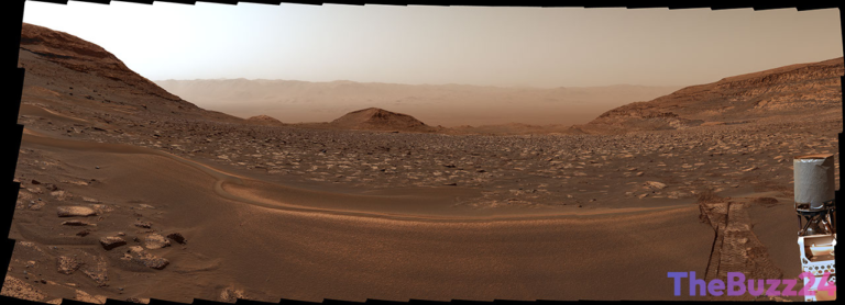
NASA’s Curiosity rover has transmitted a breathtaking panorama capturing a Martian sunrise casting its light upon ancient, wind-carved geological formations known as yardangs. The image, taken on August 11, 2026, during the mission’s 4,982nd Martian day (sol), offers scientists a unique glimpse into the planet’s geological history.
The yardangs, prominent features illuminated by the early morning sun, are located on the shoulder of Mount Sharp, the towering 3-mile-tall mountain Curiosity has been exploring since 2014. This mountain is composed of distinct layers, each representing a chapter in Mars’s climate history. The yardang layer, however, presents a puzzle for researchers. It’s theorized that this layer might represent a period of erosion that created a break in the otherwise continuous geological record, or it could be a deposit of volcanic ash, similar to formations found near the Martian equator.
This stunning vista was assembled from six individual images captured by Curiosity’s Mastcam instrument. In an artistic decision to preserve the authentic appearance of the Martian dawn, the image was processed without the standard white balancing. This allows viewers to experience the sunrise much as it would appear on the Red Planet, highlighting the subtle hues and dramatic shadows cast across the alien terrain.
Key Takeaways
- NASA's Curiosity rover captured a Martian sunrise illuminating wind-carved yardangs.
- The yardang layer on Mount Sharp may represent a gap in Mars's climate history or volcanic ash deposits.
- The image was processed without white balancing to preserve the natural appearance of the Martian dawn.
Editor’s Analysis & Impact
This image from the Curiosity rover provides more than just a visually striking depiction of Mars; it offers valuable scientific data. The detailed view of the yardangs and the context of their location on Mount Sharp are crucial for understanding Martian geological processes and past environmental conditions. The potential break in the geological record highlighted by the yardang layer could significantly refine our understanding of Mars’s climate evolution. As Curiosity continues its ascent, such findings underscore the importance of ongoing robotic exploration in piecing together the Red Planet’s complex history and informing future missions.
Frequently Asked Questions
Q: What are yardangs?
A: Yardangs are streamlined, wind-eroded ridges found on rocky or sandy terrains, often on planets like Mars. They are shaped by the persistent action of wind carrying abrasive particles.
Q: Why is the yardang layer significant for scientists?
A: The yardang layer is significant because it might represent a period of erosion that interrupted the continuous deposition of Mount Sharp's layers, potentially creating a gap in Mars's climate history. Understanding its formation could reveal more about past Martian environments.
Q: What is Mount Sharp?
A: Mount Sharp, officially Aeolis Mons, is a large mountain located near the center of Gale Crater on Mars. It is the primary target of NASA's Curiosity rover mission, and its layers are studied to understand the planet's geological past.
AI Disclosure: This article is based on verified data and official reports. Our Team and AI have cross-referenced every financial detail with primary sources to ensure total accuracy.
More from this Category