El Niño Fuels Intense Pacific Hurricane Season, Unleashing Widespread Deluge and Destruction
The northeastern and central Pacific basins are experiencing an exceptionally active tropical cyclone season in 2026, significantly surpassing historical averages. As of late September, the region had already recorded 20 named storms, with nine reaching hurricane strength. This compares to a 1991-2020 average of 13.5 named storms and 7.4 hurricanes by the same date, indicating a marked increase in storm intensity and frequency.
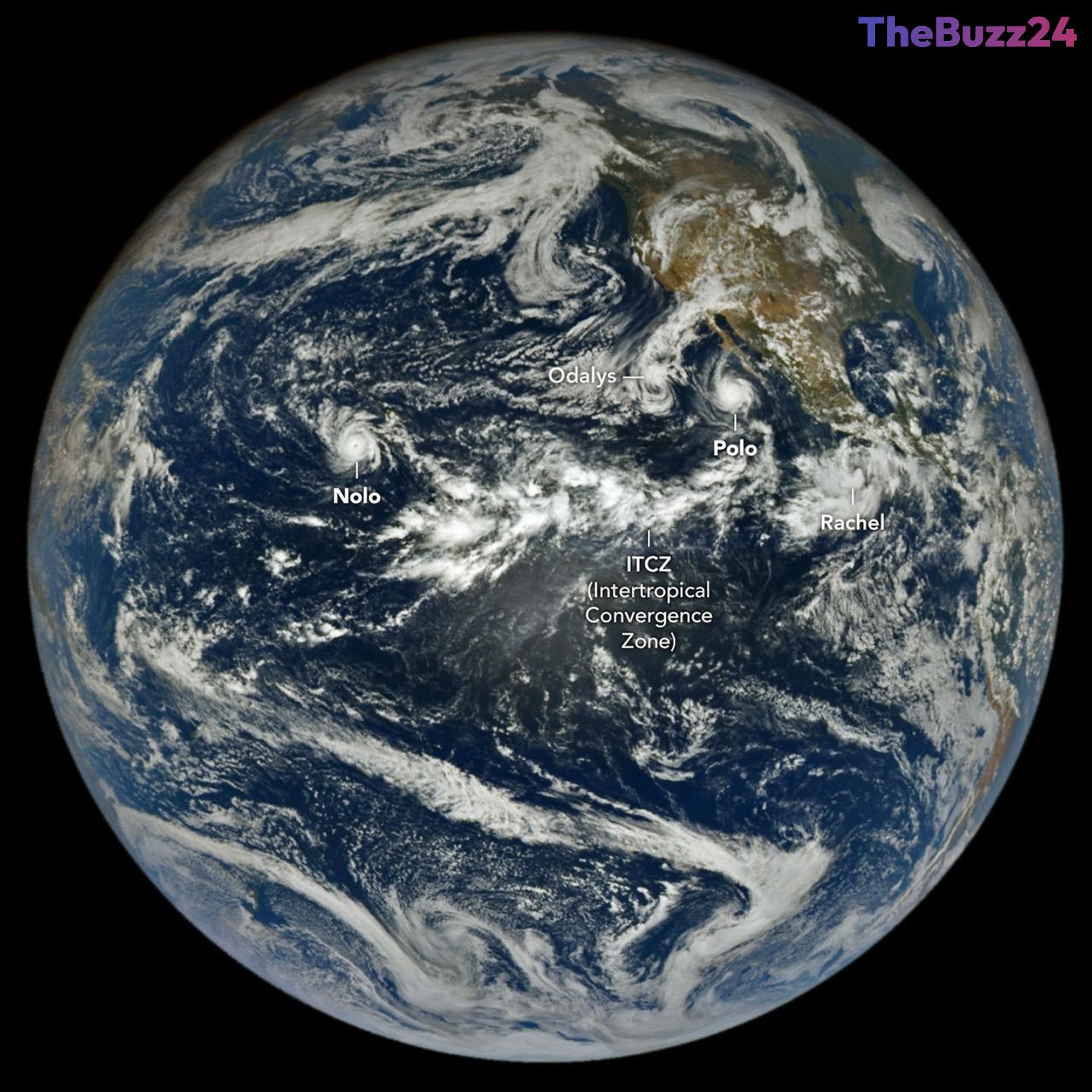
Among the most impactful systems were Hurricane Polo, which made two landfalls in Mexico, and Hurricane Nolo, which brought substantial rainfall to Hawaii. Hurricane Polo, captured by NASA’s EPIC camera on the DSCOVR satellite, underwent extreme rapid intensification, reaching Category 5 status over unusually warm ocean waters before weakening to a Category 2 upon its initial landfall in Baja California Sur. It later made a second landfall near Guaymas, Mexico, as a further weakened system. Forecasters warned of dangerous winds, storm surge, and heavy rains capable of triggering widespread flooding and mudslides across Baja California Sur and Sonora. The remnants of Polo, combined with moisture from Post-Tropical Cyclone Odalys, were also projected to bring significant flood risks to the southwestern U.S. and southern Plains.
Meanwhile, Hurricane Nolo marked the third hurricane of the season to impact Hawaii, delivering over 12 inches (30 centimeters) of rain to parts of Maui and the Island of Hawaiʻi. While the Island of Hawaiʻi was spared the more severe devastation seen from Hurricane Lala in mid-August, Nolo still caused flooded roads, downed trees, and landslides. Concurrently, Tropical Storm Rachel tracked parallel to the southwest Mexico coast, posing threats of strong winds and dangerous surf conditions.
The heightened activity in the Pacific is largely attributed to an ongoing El Niño event, which commenced in June. El Niño conditions, characterized by warmer-than-average ocean temperatures in the equatorial Pacific and reduced wind shear, create an environment highly conducive to the development and strengthening of tropical cyclones. Data from Colorado State University indicates that the accumulated cyclone energy in the Northeast Pacific is currently more than double the norm. In response to these severe events, the NASA Disasters Program, in collaboration with FEMA, is actively supporting Hawaii’s recovery efforts from Hurricane Nolo, providing critical mapping and data products to aid in disaster response.
Key Takeaways
- The 2026 Pacific hurricane season is significantly more active than average, with 20 named storms and 9 hurricanes by late September, driven by El Niño conditions.
- Hurricane Polo caused widespread disruption, making two landfalls in Mexico after rapid intensification, and its remnants, combined with moisture from Post-Tropical Cyclone Odalys, are threatening the U.S. Southwest with heavy flooding.
- Hawaii experienced its third hurricane impact of the season with Nolo, which brought over a foot of rain, flooding, and landslides, prompting a coordinated response from the NASA Disasters Program and FEMA.
Editor’s Analysis & Impact
The unprecedented intensity of the 2026 Pacific hurricane season, fueled by El Niño, carries significant implications across various sectors. Economically, regions like Baja California Sur, Sonora, and Hawaii face substantial costs for infrastructure repair, agricultural losses, and potential downturns in tourism. The insurance industry will likely see a surge in claims, potentially leading to increased premiums in vulnerable areas. From a broader perspective, this season underscores the escalating challenges posed by climate variability and change, demanding greater investment in resilient infrastructure, advanced early warning systems, and robust disaster preparedness strategies. The strain on emergency services and supply chains will continue to grow, highlighting the critical need for inter-agency cooperation and scientific monitoring to mitigate future impacts and support long-term recovery efforts.
Frequently Asked Questions
Q: What is El Niño and how does it affect hurricane activity?
A: El Niño is a climate pattern characterized by unusually warm ocean temperatures in the equatorial Pacific. These warmer waters, combined with reduced wind shear, create favorable conditions for tropical storms to form and strengthen in the Pacific basin, leading to more active hurricane seasons.
Q: Which regions were most significantly impacted by the recent Pacific storms?
A: The recent storms, including Hurricanes Polo and Nolo, primarily impacted Baja California Sur and Sonora in Mexico, the southwestern United States (due to remnants), and the Hawaiian Islands (Maui and Island of Hawaiʻi).
Q: What measures are being taken to respond to these severe weather events?
A: Emergency services, including the National Hurricane Center, issued warnings and advisories. The NASA Disasters Program, in coordination with FEMA, is providing support to affected regions like Hawaii, offering maps and data products to aid response and recovery efforts.
AI Disclosure: This article is based on verified data and official reports. Our Team and AI have cross-referenced every financial detail with primary sources to ensure total accuracy.
More from this Category