Unveiling the Richat Structure: The Geological Mystery of the Sahara
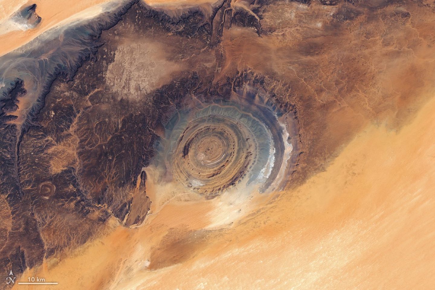
Deep within the remote Adrar Plateau of Mauritania lies a geological phenomenon so distinct that it has become a landmark for astronauts and scientists alike. Known as the Richat Structure, or the ‘Eye of the Sahara,’ this massive circular formation spans roughly 40 kilometers in diameter. Recent high-resolution imagery captured by the Landsat 9 and Landsat 8 satellites has provided a fresh, detailed perspective of the site, highlighting the stark contrast between its concentric ridges and the surrounding desert landscape.
Beyond its geological significance, the region serves as a silent witness to human history. The area is rich with archaeological evidence, including Paleolithic stone tools and Neolithic cave art, suggesting that the site was once a hub for ancient civilizations and a critical waypoint for trans-Saharan trade caravans. While the desert winds have continuously reshaped the surrounding sand dunes and plateaus, the Richat Structure has remained a persistent, enigmatic feature of the African landscape since it was first formally documented in the 1930s.
For decades, the structure’s perfect circularity led many to believe it was the result of a massive meteor impact. However, modern geological analysis has debunked this theory, confirming that the site is actually a deeply eroded geological dome. The formation was created by the uplift of rock layers caused by an underground intrusion of molten igneous material. As the dome eroded over millions of years, the varying resistance of the exposed sedimentary and igneous rock layers formed the distinct, ring-like cuestas that define the structure’s appearance today.
Key Takeaways
- The Richat Structure is a 40-kilometer-wide geological dome, not an impact crater as previously theorized.
- The site is a significant archaeological location, containing evidence of human activity dating back to the Paleolithic era.
- Recent satellite imagery from Landsat 8 and 9 has provided new, detailed insights into the formation's unique concentric ridges.
Editor’s Analysis & Impact
The Richat Structure remains a focal point for both geological research and public fascination, serving as a prime example of how natural erosion can mimic catastrophic events. From a scientific perspective, the site offers a unique window into the tectonic history of the African plate and the processes of igneous intrusion. As satellite imaging technology continues to advance, the ability to monitor such remote geological features in high resolution allows researchers to better understand landscape evolution without the need for invasive ground-level exploration. The ‘Eye of the Sahara’ not only highlights the importance of preserving geological heritage but also underscores the necessity of interdisciplinary study, combining geology with archaeology to map the full history of the region’s environmental and human development.
Frequently Asked Questions
Q: Is the Richat Structure an impact crater?
A: No. While its circular shape initially led researchers to believe it was caused by a meteor, scientific investigation has confirmed it is a deeply eroded geological dome formed by an underground igneous intrusion.
Q: Why is it called the 'Eye of the Sahara'?
A: The name was popularized after astronauts on the Gemini IV mission photographed the structure from orbit, where its concentric rings and massive size give it the appearance of a giant eye looking up from the desert floor.
AI Disclosure: This article is based on verified data and official reports. Our AI have cross-referenced every financial detail with primary sources to ensure total accuracy.
More from this Category