Majestic Heights: Exploring the Dynamic Geology and Ecology of Washington’s Olympic Peninsula
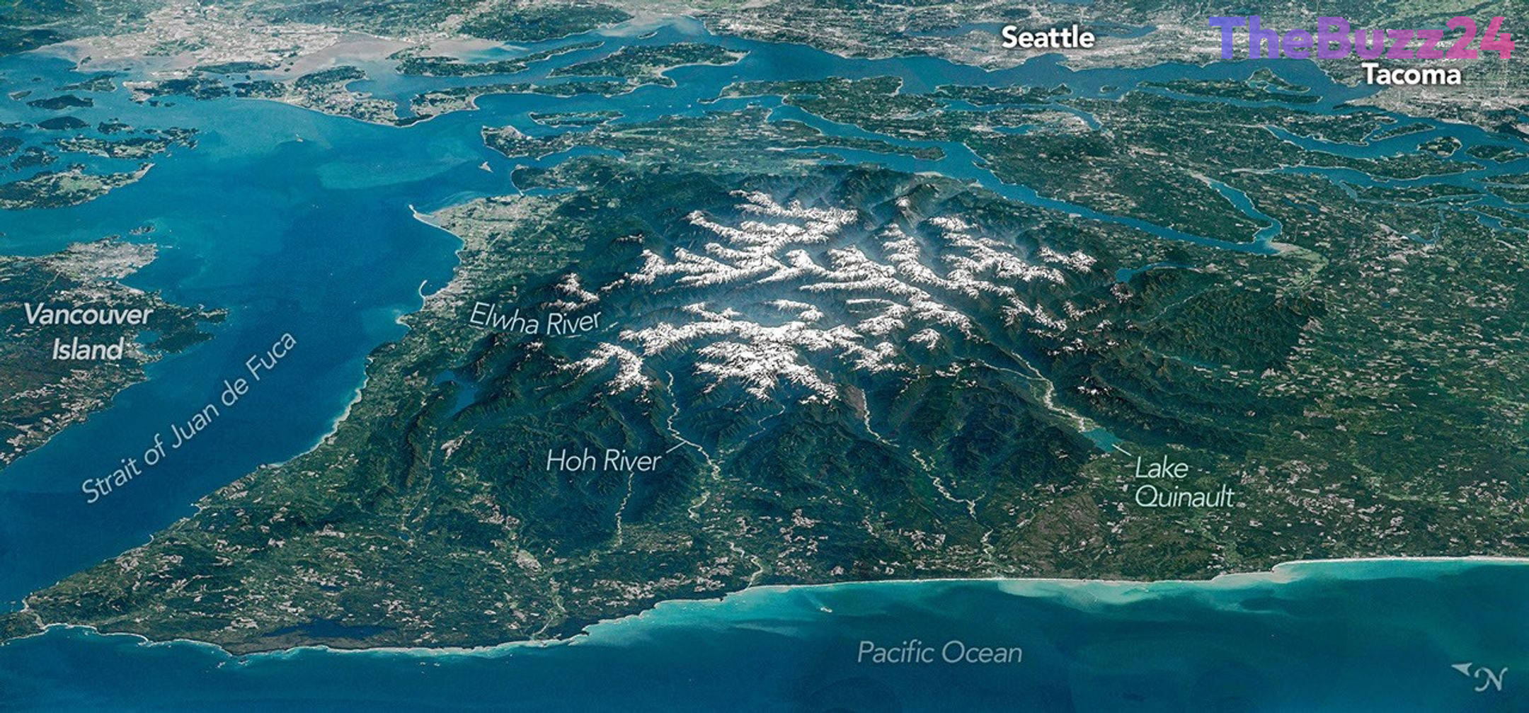
The Olympic Peninsula in Washington state stands as a striking testament to the raw power of nature, where alpine glaciers, temperate rainforests, and rugged coastlines converge. Captured in stunning detail through a panoramic composite created by astronauts aboard the International Space Station, the imposing terrain of the Olympic Mountains dominates the region’s wild interior. Protected largely within national park boundaries, national forests, and tribal lands, this diverse ecosystem remains a vital ecological sanctuary in the Pacific Northwest.
Formed over millions of years, the bedrock of the Olympic Mountains tells a story of ancient tectonic upheaval. Between 55 and 15 million years ago, layers of basalt from undersea eruptions and sediment carried by rivers accumulated on the ocean floor. As the Juan de Fuca plate subducted beneath the North American plate, these rock layers were scraped off and violently thrust upward, eventually rising thousands of feet above sea level. Today, these peaks continue to experience intense geological pressures, though this upward momentum is heavily counterbalanced by relentless erosion from rain, snow, and glacial activity.
Water plays a central role in shaping the peninsula’s geography, fueling both breathtaking landscapes and complex environmental histories. Rivers like the Hoh, Queets, and Quinault carve deep valleys toward the Pacific Ocean, nurturing ancient temperate rainforests renowned for their profound natural quiet. Meanwhile, the Elwha River has undergone a dramatic transformation in recent years. Following the historic removal of two major hydroelectric dams in the early 2010s, the river system has seen a remarkable ecological revival, enabling salmon to return to their historic spawning grounds and restoring natural sediment flows to the Strait of Juan de Fuca.
Key Takeaways
- Astronauts captured a unique panoramic view of Washington's Olympic Peninsula, highlighting its rugged peaks and diverse ecosystems.
- The Olympic Mountains were formed by tectonic subduction, where ancient ocean-floor sediment and basalt were pushed thousands of feet upward.
- Recent large-scale dam removals on the Elwha River have successfully revived local fish populations and restored natural sediment flows.
Editor’s Analysis & Impact
The geographic and ecological evolution of the Olympic Peninsula offers critical insights into the delicate balance between tectonic forces and environmental change. As glacial retreat accelerates due to shifting climatic patterns, regions like the Olympic Mountains serve as important barometers for long-term ecological monitoring. Furthermore, the successful restoration of the Elwha River ecosystem provides a blueprint for future dam removal and watershed rehabilitation projects globally. Understanding these dynamic environments helps scientists model how both natural topography and human intervention influence biodiversity, water security, and regional climate resilience in mountainous terrain.
Frequently Asked Questions
Q: How were the Olympic Mountains originally formed?
A: The mountains were formed between 55 and 15 million years ago when undersea basalt, sand, and mud accumulated on the ocean floor and were thrust upward as the Juan de Fuca plate subducted beneath the North American plate.
Q: What is the significance of the Elwha River project?
A: Two major dams on the Elwha River were removed between 2011 and 2014 in what was then the largest project of its kind in the U.S., successfully restoring fish migration, native plant communities, and sediment flow.
Q: Are glaciers still present in the Olympic Mountains?
A: Yes, but they are retreating and thinning. A 2015 study recorded 255 glaciers and perennial snowfields, noting that dozens had disappeared over the preceding 35 years.
AI Disclosure: This article is based on verified data and official reports. Our Team and AI have cross-referenced every financial detail with primary sources to ensure total accuracy.
More from this Category