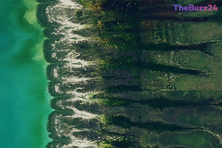
Putting Your Geography Skills to the Test with the August 2026 Satellite Puzzler
Geography enthusiasts and space imagery fans have a new opportunity to test their observational skills with the release of the August 2026 satellite puzzler. Participants from around the globe are invited to examine a newly published orbital image and attempt to pinpoint the exact geographic location it captures.
To successfully solve the puzzle, observers must look beyond a simple guess and analyze environmental markers, geological formations, and unique surface features visible from space. Those looking to stand out can dive deeper by identifying the specific satellite and instrument responsible for capturing the shot, detailing the spectral bands utilized, or uncovering historical context related to the terrain.
Submissions are currently open through an online portal, where participants can submit their location theories alongside any fascinating insights they discover. While the challenge does not offer monetary rewards or space travel, successful sleuths earn recognition, community bragging rights, and the chance to be featured when the official answer and detailed geographical breakdown are revealed in the coming weeks.
Key Takeaways
- The August 2026 satellite puzzler challenges geography fans to identify a mystery location captured from space.
- Participants can submit their guesses and detailed geological observations through an online form.
- Winners receive community recognition and bragging rights when the official answer is published.
Editor’s Analysis & Impact
Public engagement initiatives like orbital image puzzlers play a vital role in fostering scientific literacy and public interest in Earth sciences. By transforming complex remote sensing data into an interactive game, space agencies and educational platforms effectively bridge the gap between advanced technology and the general public. These challenges encourage participants to develop critical thinking skills regarding geography, environmental science, and data analysis. As satellite imaging technology continues to advance with higher resolutions and more sophisticated spectral bands, the educational potential of these initiatives grows, inspiring the next generation of scientists, geographers, and researchers to explore our planet from a macro perspective.
Frequently Asked Questions
Q: How can I participate in the satellite puzzler?
A: You can participate by viewing the monthly satellite image, identifying the location, and submitting your answer using the official online form with 'Puzzler Answer' selected as the topic.
Q: What kind of information should I include in my submission?
A: You can keep it as simple as a location guess, or include advanced details such as the specific satellite and instrument used, spectral bands, and geological or historical facts about the area.
Q: When and where will the answer be announced?
A: The official answer and a detailed breakdown of the image are typically posted on the main page about a week after the challenge begins.
AI Disclosure: This article is based on verified data and official reports. Our Team and AI have cross-referenced every financial detail with primary sources to ensure total accuracy.
More from this Category