Record-Breaking Floods Devastate Regions Along the Gandak River
Torrential rainfall across Nepal’s Lumbini and Gandaki provinces between September 24 and 27, 2026, has triggered catastrophic flooding and landslides. The late-monsoon deluge caused the Gandak River, also known as the Narayani, to surge to unprecedented levels, overwhelming embankments and inundating vast stretches of land across both Nepal and India.
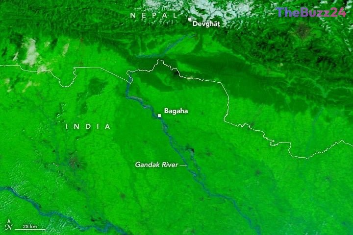
Satellite imagery comparing conditions on September 20 and September 29 reveals a dramatic expansion of the river, with floodwaters spilling far beyond the traditional channel. The surge has severely impacted hundreds of villages, displacing thousands of residents and destroying critical farmland. In Nepal, water levels at the Devghāṭ gauge reached 11.94 meters on September 27, marking the highest level recorded since monitoring began in the 1960s.
The impact extended deep into India, where multiple gauge stations, including those at Bagaha, Dumariaghat, Rewaghat, and Lalganj, reported record-breaking water levels. The breach of protective embankments has left communities in districts such as West Champaran vulnerable, prompting emergency relief operations to address the widespread displacement and infrastructure damage caused by the rising waters.
Key Takeaways
- Late-monsoon storms caused the Gandak River to reach record-high water levels in both Nepal and India.
- Satellite data confirms significant flooding, with the river breaching embankments and inundating hundreds of villages.
- Emergency response efforts are underway as thousands of people remain displaced due to the destruction of homes and farmland.
Editor’s Analysis & Impact
The 2026 Gandak River flooding highlights the increasing volatility of monsoon patterns in South Asia, a region already highly susceptible to climate-induced hydrological extremes. The fact that multiple gauge stations simultaneously hit record highs suggests a systemic failure of existing flood defense infrastructure, which was likely designed for historical norms that no longer apply. Economically, the destruction of farmland in these low-lying areas poses a significant threat to local food security and livelihoods, necessitating a shift toward more resilient infrastructure and improved early-warning systems. Future outlooks indicate that as atmospheric moisture capacity increases, the frequency of such ‘record-breaking’ events will likely rise, forcing governments to prioritize long-term climate adaptation strategies over reactive disaster management.
Frequently Asked Questions
Q: What caused the flooding of the Gandak River?
A: The flooding was caused by a period of intense, torrential rainfall between September 24 and 27, 2026, which occurred late in the monsoon season.
Q: How severe was the water level rise?
A: The water levels were historic; for example, the gauge at Devghāṭ in Nepal reached 11.94 meters, the highest measurement recorded since the 1960s.
AI Disclosure: This article is based on verified data and official reports. Our Team and AI have cross-referenced every financial detail with primary sources to ensure total accuracy.
More from this Category