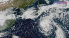
Satellite Imagery Captures Intense Path of Typhoon Approaching Japan
A powerful typhoon is currently tracking toward the Japanese archipelago, prompting meteorological agencies to issue urgent warnings regarding severe weather conditions. Satellite footage released this week provides a stark visual representation of the storm’s intensity, showing a massive, swirling cloud formation barrelling across the Pacific Ocean with significant structural organization.
As the system nears the coast, authorities are bracing for heavy rainfall, high-velocity winds, and the potential for dangerous storm surges. Residents in the projected path of the typhoon have been advised to secure outdoor property and prepare for potential disruptions to transportation and power infrastructure. Local officials are closely monitoring the storm’s trajectory to determine the necessity of evacuation orders in vulnerable coastal regions.
This weather event highlights the increasing frequency of intense tropical cyclones in the region. Emergency management teams remain on high alert, coordinating with local municipalities to ensure that disaster response protocols are in place. The public is encouraged to stay updated through official channels as the storm makes its final approach toward the mainland.
Key Takeaways
- A major typhoon is currently moving toward Japan, bringing risks of severe wind and heavy rainfall.
- Satellite imagery confirms the storm's significant size and organized structure as it approaches the coast.
- Local authorities are urging residents to prepare for potential infrastructure disruptions and follow official evacuation guidance.
Editor’s Analysis & Impact
The increasing frequency and intensity of typhoons in the Western Pacific present a growing challenge for Japan’s infrastructure and disaster preparedness frameworks. As climate patterns shift, the economic impact of these storms—ranging from supply chain disruptions to the costs of rebuilding—continues to rise. For businesses operating in the region, this underscores the necessity of robust business continuity planning and climate-resilient logistics. Looking forward, the integration of advanced AI-driven meteorological modeling will be critical for providing earlier, more accurate warnings. The broader implication is a shift in how urban planning and coastal development are approached, with a greater emphasis on long-term climate adaptation strategies to mitigate the recurring risks posed by extreme weather events.
Frequently Asked Questions
Q: What should residents do when a typhoon warning is issued?
A: Residents should secure loose outdoor items, prepare an emergency kit, monitor local news for evacuation orders, and identify the nearest designated shelter.
Q: How do satellite images help in tracking typhoons?
A: Satellite imagery allows meteorologists to observe the storm's eye, cloud structure, and wind patterns in real-time, which is essential for predicting the storm's path and intensity.
AI Disclosure: This article is based on verified data and official reports. Our Team and AI have cross-referenced every financial detail with primary sources to ensure total accuracy.
More from this Category