Geological Transformation: Papua New Guinea Faces Aftermath of Cyclone Maila
Papua New Guinea is grappling with a significant environmental crisis following the passage of Tropical Cyclone Maila, a Category 4 storm that caused unprecedented geological shifts across the nation. The cyclone exhibited rare meteorological behavior in mid-April 2026, stalling near the equator over East New Britain. This stationary position led to a prolonged period of historic rainfall, which destabilized the mountainous terrain and triggered widespread catastrophic landslides.
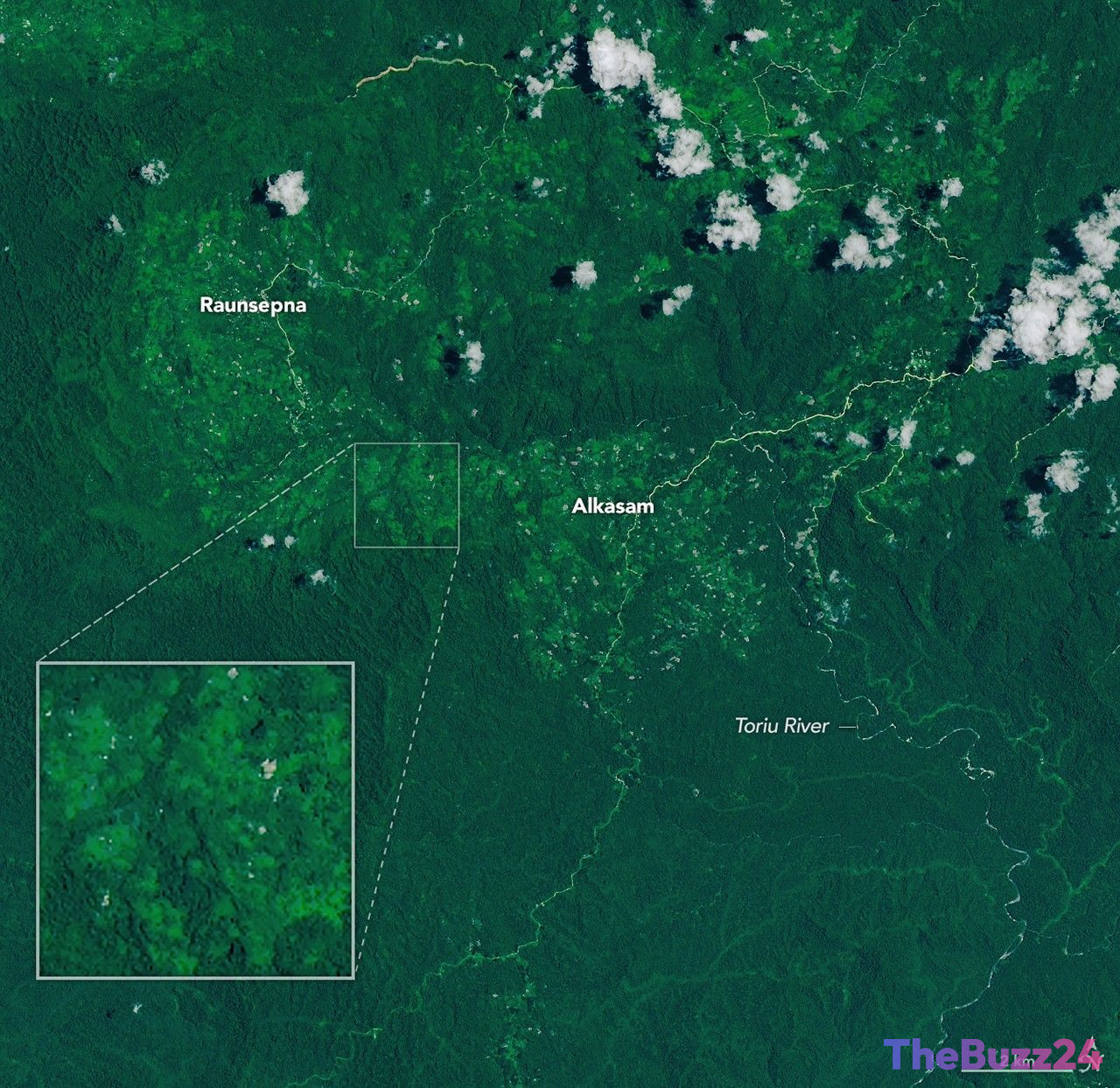
Aerial surveys and satellite data have confirmed that the Baining Mountains suffered the most severe damage. On April 9, the intense saturation of the soil led to massive slope failures, which destroyed large swaths of forest and fundamentally altered the path of the Toriu River. The scale of the debris flows has permanently reshaped the local topography, overwhelming existing drainage systems and rendering previous geological risk assessments insufficient for the volume of water delivered by the storm.
Beyond the immediate destruction in the Baining Mountains, the cyclone’s impact extended across New Britain, Bougainville, and New Ireland, leaving numerous remote communities isolated. Emergency response teams are currently working to navigate the treacherous, altered landscape to reach affected populations. The focus has now shifted toward long-term land stabilization and the monumental task of rebuilding infrastructure in regions where the geography itself has been fundamentally changed.
Key Takeaways
- Tropical Cyclone Maila stalled near the equator, causing historic rainfall and extreme geological instability in Papua New Guinea.
- The Baining Mountains experienced massive slope failures and debris flows that permanently altered the region's topography and river systems.
- Emergency efforts are underway to reach isolated communities across New Britain, Bougainville, and New Ireland as the nation begins infrastructure recovery.
Editor’s Analysis & Impact
The devastation caused by Cyclone Maila highlights a growing vulnerability in regions where extreme weather events are beginning to outpace traditional geological risk modeling. By stalling over a specific area, the cyclone demonstrated how climate-related phenomena can cause localized, permanent landscape alteration that exceeds historical precedents. For Papua New Guinea, this event poses a significant challenge to infrastructure planning and disaster resilience. The long-term implications involve not only the immediate cost of reconstruction but also the necessity of re-evaluating land-use policies in mountainous zones. As climate patterns become increasingly unpredictable, the ability to forecast such stationary, high-intensity events will be critical for regional stability. Future development in these areas must now account for a new baseline of environmental volatility, potentially necessitating more robust engineering solutions to mitigate the risk of future slope failures.
Frequently Asked Questions
Q: What made Tropical Cyclone Maila particularly dangerous for Papua New Guinea?
A: The cyclone was dangerous because it stalled near the equator, leading to a prolonged period of historic rainfall that saturated the soil and triggered massive, landscape-altering landslides.
Q: Which areas were most affected by the storm?
A: The Baining Mountains bore the brunt of the impact, but the storm also caused significant damage and isolation across New Britain, Bougainville, and New Ireland.
AI Disclosure: This article is based on verified data and official reports. Our Team and AI have cross-referenced every financial detail with primary sources to ensure total accuracy.
More from this Category