Perseverance Rover Captures Unprecedented 360-Degree View of Ancient Martian Landscape
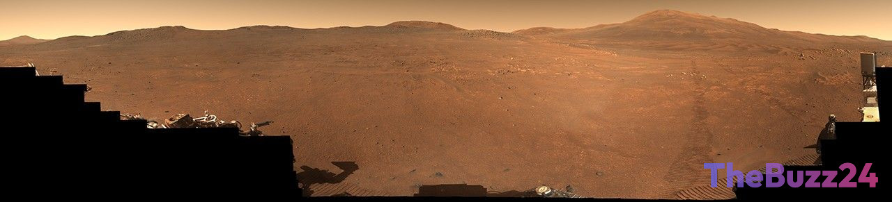
The Perseverance Mars rover has successfully completed a massive imaging project, resulting in a high-resolution 360-degree panorama of the ‘Crocodile Bridge’ region. Situated along the rim of the Jezero Crater, this geological site was captured through 980 individual frames taken by the rover’s Mastcam-Z camera system. The project, which spanned two months between late 2025 and early 2026, provides a natural-color view that offers scientists an unprecedented look at the Martian terrain with clarity comparable to human vision.
Researchers are particularly interested in the ‘Crocodile Bridge’ area because of the extreme age of its rock formations. Unlike Earth, Mars does not experience active plate tectonics, meaning its surface has remained largely undisturbed for billions of years. This geological stability serves as a natural time capsule, preserving the planet’s formative history and offering scientists a rare glimpse into the environmental conditions that existed during the early stages of our solar system.
As the mission moves forward, controllers are directing the rover toward a new target known as ‘Lac de Charmes.’ This next phase of exploration will focus on intensive data collection and analysis of the surrounding geological strata. By studying these ancient structures, the mission team hopes to reconstruct the evolutionary history of Mars and gain a deeper understanding of the processes that transformed the planet into the arid world observed today.
Key Takeaways
- The Perseverance rover assembled a 980-frame, 360-degree panorama of the 'Crocodile Bridge' site on the Jezero Crater rim.
- The region provides a unique geological record because the lack of tectonic activity on Mars has kept the rock formations largely undisturbed for billions of years.
- The mission is now shifting its focus toward the 'Lac de Charmes' area to continue analyzing ancient geological structures.
Editor’s Analysis & Impact
The successful imaging of ‘Crocodile Bridge’ marks a pivotal moment in our efforts to decode the geological history of Mars. By targeting the rim of the Jezero Crater, the Perseverance mission is accessing some of the most pristine, ancient material available for study. The absence of tectonic recycling on the Red Planet makes these sites invaluable, as they provide an undisturbed look at early solar system conditions. The transition to the ‘Lac de Charmes’ area indicates a strategic shift toward analyzing diverse geological strata, which is essential for identifying potential biosignatures or evidence of past water activity. As the mission progresses, the data gathered from these ancient formations will likely refine our models of planetary evolution and provide critical insights for future robotic and human exploration strategies.
Frequently Asked Questions
Q: Why is the 'Crocodile Bridge' area scientifically significant?
A: It contains some of the oldest rock formations in the solar system, which have been preserved due to the lack of tectonic activity on Mars, effectively acting as a time capsule for the planet's history.
Q: How was the 360-degree panorama of the Martian terrain created?
A: The image was constructed by stitching together 980 individual high-resolution frames captured by the rover's Mastcam-Z camera system over a two-month period.
AI Disclosure: This article is based on verified data and official reports. Our Team and AI have cross-referenced every financial detail with primary sources to ensure total accuracy.
More from this Category