Satellite Imagery Captures Massive Scar Left by Mississippi EF-3 Tornado
A powerful supercell storm system swept across southern Mississippi on May 6, 2026, unleashing a series of destructive tornadoes that caused widespread devastation. Among these, a particularly intense EF-3 tornado carved an 82-mile path of destruction, traversing five counties with wind speeds reaching 137 miles per hour. The storm left behind a trail of structural ruin and significant environmental damage, marking one of the most severe weather events in the region this year.
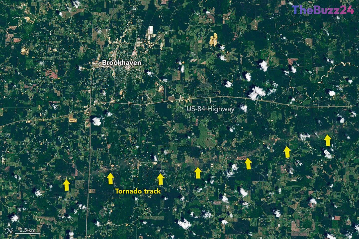
High-resolution satellite imagery has provided a stark visual record of the event, highlighting a distinct, jagged brown scar across the landscape. This path, most visible south of Brookhaven in Lincoln County, illustrates the sheer force of the winds, which snapped mature trees and stripped vegetation bare. Beyond the environmental impact, the tornado caused catastrophic damage to residential areas, including a mobile home park where several structures suffered total wall collapses.
This event was part of a broader outbreak that saw seven tornadoes strike the state in a single evening. The cumulative damage across Mississippi is extensive, affecting over 400 homes, numerous businesses, and critical agricultural infrastructure. The primary tornado’s trajectory, which began near the St. Catherine Creek National Wildlife Refuge, also resulted in the destruction of transmission towers, leading to localized power disruptions.
While the southeastern United States is often distinguished from the traditional ‘Tornado Alley’ of the central plains, this event underscores the region’s increasing vulnerability to severe weather. Meteorological data suggests a shifting pattern in storm activity, with a notable rise in the frequency and intensity of tornado events occurring throughout the Southeast during the spring months.
Key Takeaways
- An EF-3 tornado traveled 82 miles across five Mississippi counties, reaching peak wind speeds of 137 mph.
- Satellite imagery confirms extensive environmental and structural damage, including the destruction of over 400 homes.
- Meteorological trends indicate a shift in severe weather patterns, with increased tornado frequency in the Southeast compared to traditional regions.
Editor’s Analysis & Impact
The May 2026 Mississippi tornado outbreak serves as a critical data point for meteorologists studying the eastward shift of severe weather activity. Historically, the ‘Tornado Alley’ moniker focused on the Great Plains, but recent years have shown a consistent increase in high-intensity storms across the Southeast. This shift poses significant challenges for urban planning, building codes, and emergency management in states that may not have historically prioritized tornado-resistant infrastructure to the same degree as the Midwest. From an economic perspective, the destruction of over 400 homes and critical agricultural buildings will likely lead to a surge in insurance claims and a localized economic downturn as communities focus on recovery. Future infrastructure projects in this region will likely need to incorporate more stringent wind-resistance standards to mitigate the risks posed by this evolving climate reality.
Frequently Asked Questions
Q: What is an EF-3 tornado?
A: An EF-3 tornado is a 'severe' tornado on the Enhanced Fujita Scale, characterized by wind speeds between 136 and 165 mph, capable of causing severe damage to well-constructed homes and uprooting large trees.
Q: Are tornadoes becoming more common in the Southeast?
A: Yes, recent meteorological observations suggest a shifting pattern in storm activity, with an increasing frequency of tornado events being recorded in the southeastern United States compared to the traditional central plains.
AI Disclosure: This article is based on verified data and official reports. Our Team and AI have cross-referenced every financial detail with primary sources to ensure total accuracy.
More from this Category