Record-Breaking Wildfire Scorches Santa Rosa Island
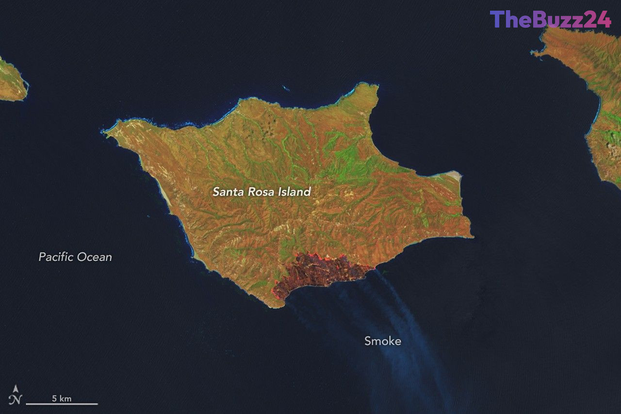
A massive wildfire has left a significant mark on California’s Channel Islands National Park, consuming approximately 18,379 acres of Santa Rosa Island. The blaze, which was first detected on May 15, 2026, on the island’s southeastern side, ultimately scorched roughly one-third of the island’s total landmass. By May 26, emergency crews had managed to bring the fire to 97 percent containment, marking the end of the largest wildfire event ever recorded on any of the Channel Islands.
Satellite imagery captured by the Landsat 8 and 9 missions provided a clear view of the fire’s progression between May 16 and May 24. The false-color data revealed the fire’s rapid expansion as it moved north and east, consuming vast stretches of grassland, coastal sage scrub, and island chaparral. The use of advanced remote sensing tools allowed officials to track the fire front in real-time, which proved critical in directing suppression efforts to protect the island’s most sensitive ecological zones.
Conservationists expressed significant concern regarding the fire’s proximity to the island’s rare Torrey pine stands, which are found naturally only on the northeastern coast of Santa Rosa Island and near San Diego. Fortunately, initial post-fire assessments indicate that the majority of the Torrey pine canopy remained intact, as the fire burned with lower intensity in those specific areas. Suppression teams also successfully protected the island’s unique cloud forests by cooling fuels ahead of the advancing flames, though some pockets of forest did sustain damage where fire intensity was higher.
While some plant species on the Channel Islands possess adaptations for fire, they are generally less dependent on it than mainland vegetation due to the lower frequency of natural fire cycles in the region. The National Park Service continues to monitor the recovery of the landscape as the island begins the long process of ecological stabilization following this historic event.
Key Takeaways
- The wildfire on Santa Rosa Island burned 18,379 acres, making it the largest fire on record for California's Channel Islands.
- Satellite monitoring played a vital role in tracking the fire's spread and protecting vulnerable ecosystems like the rare Torrey pine stands.
- While the fire caused significant damage to grasslands and chaparral, the island's cloud forests and pine canopies were largely spared due to targeted suppression efforts.
Editor’s Analysis & Impact
The Santa Rosa Island fire highlights the increasing vulnerability of isolated, biodiversity-rich ecosystems to extreme weather events. As climate patterns shift, the frequency and intensity of wildfires in regions historically less prone to such events are forcing a reevaluation of land management and conservation strategies. The successful protection of the rare Torrey pine stands demonstrates the efficacy of modern satellite-based fire tracking and rapid-response suppression tactics. However, the broader implication is that even remote, protected areas are not immune to the escalating threat of wildfires. Future conservation efforts will likely need to prioritize more aggressive fuel management and enhanced monitoring infrastructure to preserve rare species that lack the evolutionary resilience to recover from high-intensity burns.
Frequently Asked Questions
Q: How much of Santa Rosa Island was affected by the fire?
A: The fire burned approximately 18,379 acres, which accounts for about one-third of the island's total area.
Q: Were the rare Torrey pines destroyed in the fire?
A: Most of the Torrey pine stands remained intact. The fire burned with lower intensity in those areas, sparing the canopy, although some pockets of forest did sustain damage.
AI Disclosure: This article is based on verified data and official reports. Our Team and AI have cross-referenced every financial detail with primary sources to ensure total accuracy.
More from this Category