Tropical Storm Arthur Unleashes Early Season Fury on Gulf Coast
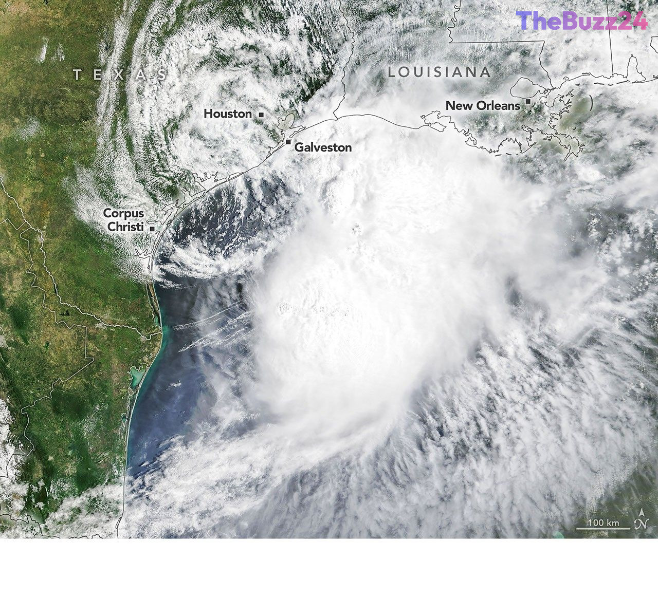
The U.S. Gulf Coast experienced the early onset of the 2026 Atlantic hurricane season with the arrival of Tropical Storm Arthur in mid-June. As the first named storm of the year, Arthur brought significant winds and torrential rainfall to the region, prompting warnings for residents. Satellite observations on June 17, 2026, captured the storm’s expansive cloud cover, extending from Gulf waters inland over parts of Texas and Louisiana. These images, utilizing both natural color and infrared brightness temperature data, highlighted the cooler, more intense cloud tops associated with the developing tropical system.
Despite remaining below hurricane strength, Tropical Storm Arthur delivered substantial impacts. Around the time of the satellite imagery acquisition, the system had just been officially designated a tropical storm by meteorological authorities. It generated maximum sustained winds of 40 miles (65 kilometers) per hour, with tropical-storm-force winds reaching out 175 miles (280 kilometers) from its center. Specific measurements, such as a gust of 48 miles per hour recorded in Galveston, Texas, underscored the storm’s intensity.
Beyond its strong winds, Arthur was a significant rain producer. The National Weather Service issued warnings for potentially life-threatening flash flooding across affected areas. Advanced satellite-based precipitation estimates indicated high rainfall rates over the Gulf waters and extending well inland on June 17. As the storm began to weaken and lose some organization on June 18, it continued to funnel abundant moisture into central Gulf Coast states. Southeastern Louisiana, for instance, reported rainfall rates of 3 inches (7.6 centimeters) per hour, with forecasts suggesting total storm accumulations could surpass 12 inches (30 centimeters) in some locations, potentially nearing 20 inches (51 centimeters).
Key Takeaways
- Tropical Storm Arthur was the first named storm of the 2026 Atlantic hurricane season, impacting the U.S. Gulf Coast in mid-June.
- The storm brought sustained winds of 40 mph and gusts up to 48 mph, along with extensive rainfall leading to flash flood warnings.
- Satellite imagery played a crucial role in monitoring Arthur's development and precipitation, with some areas forecast to receive over 12 inches of rain.
Editor’s Analysis & Impact
This early-season tropical storm highlights the increasing volatility of weather patterns and the critical need for robust emergency preparedness along coastal regions. While Arthur remained below hurricane strength, its significant rainfall capacity underscores the evolving threat posed by even weaker systems, particularly concerning flash flooding and infrastructure strain. For industries like insurance, agriculture, and coastal tourism, such events signal potential disruptions and increased costs. The early start to the hurricane season also prompts questions about the overall intensity and duration of the upcoming season, emphasizing the importance of advanced meteorological monitoring and public awareness campaigns to mitigate risks and protect communities.
Frequently Asked Questions
Q: What were the primary impacts of Tropical Storm Arthur?
A: The storm delivered maximum sustained winds of 40 mph, with gusts up to 48 mph, and produced torrential rainfall that led to warnings for life-threatening flash flooding, particularly in areas like southeastern Louisiana.
Q: How was Tropical Storm Arthur monitored?
A: Meteorological agencies utilized satellite imagery, including natural color and infrared data, to track the storm's development, cloud structure, and precipitation rates, aiding in forecasting and public advisories.
AI Disclosure: This article is based on verified data and official reports. Our Team and AI have cross-referenced every financial detail with primary sources to ensure total accuracy.
More from this Category