Curiosity Rover Navigates Geological Layers of Mount Sharp
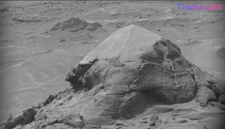
The Curiosity rover is currently making significant progress in its ascent of Mount Sharp, systematically traversing distinct geological bands that reveal the complex history of the Martian surface. During the period covering sols 4920 through 4926, the rover transitioned through areas characterized by rough-textured, dark-toned bedrock, utilizing its suite of scientific instruments to analyze the composition of these formations. Key targets, including the buttes identified as “Miraflores” and “Mishe Mokwa,” have provided researchers with valuable data regarding the layered structures and tonal variations present in the region.
Operations during this phase involved a combination of micro-imaging and chemical analysis. The rover utilized its Alpha Particle X-ray Spectrometer (APXS) and Mars Hand Lens Imager (MAHLI) to examine bedrock targets such as “Salto La Cascada” and “Santa Gracia.” Additionally, the ChemCam instrument performed LIBS spectroscopy to determine the elemental makeup of the rocks. Despite the inability to brush the rougher surfaces, the mission team successfully captured high-resolution Mastcam mosaics of nearby channels and troughs, providing a comprehensive visual record of the terrain.
While the mission encountered a minor setback due to a delayed data downlink, the rover’s autonomous capabilities ensured that scientific productivity remained high. During the communication gap, Curiosity continued its environmental monitoring, including 360-degree imaging and dust-devil surveys. As the rover moves toward a new unit of smooth-textured, light-toned material, the mission team prepares to initiate the next phase of geological surveying, continuing the long-term effort to decode the environmental evolution of Mars.
Key Takeaways
- Curiosity is currently ascending Mount Sharp, analyzing distinct geological bands that vary in texture and tone.
- The rover successfully utilized its onboard suite of instruments, including ChemCam and MAHLI, to perform chemical and visual analysis on diverse bedrock targets.
- Despite a temporary data downlink delay, the rover maintained mission momentum by conducting autonomous environmental surveys and 360-degree imaging.
Editor’s Analysis & Impact
The ongoing mission of the Curiosity rover continues to be a cornerstone of planetary science, providing granular data that informs our understanding of Martian geological history. By systematically documenting the transition between different rock units on Mount Sharp, the mission is effectively building a chronological map of the planet’s past environmental conditions. The resilience demonstrated by the mission team in managing communication delays highlights the increasing importance of autonomous rover operations in deep-space exploration. As Curiosity moves into new, lighter-toned geological units, the data gathered will likely offer further insights into the mineralogical diversity of the region, potentially identifying markers of ancient water activity or atmospheric shifts. This incremental approach to exploration remains the most effective strategy for maximizing the scientific return on long-duration robotic missions.
Frequently Asked Questions
Q: What is the primary goal of Curiosity's current mission on Mount Sharp?
A: The rover is ascending Mount Sharp to study the different geological bands of rock, which helps scientists understand the history of Mars' climate and potential for past habitability.
Q: How does the rover handle communication delays with Earth?
A: When data downlinks are delayed, the rover is programmed to continue its mission autonomously, performing pre-scheduled environmental surveys, 360-degree imaging, and atmospheric measurements until contact is restored.
AI Disclosure: This article is based on verified data and official reports. Our Team and AI have cross-referenced every financial detail with primary sources to ensure total accuracy.
More from this Category