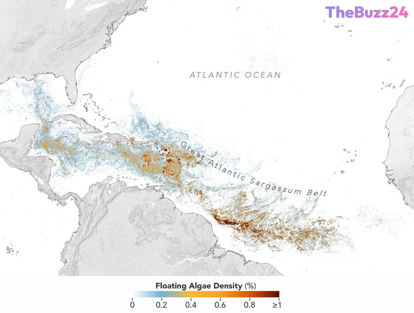
Great Atlantic Sargassum Belt Reaches Second-Highest Level on Record in 2026
The vast expanse of brown floating seaweed known as the Great Atlantic Sargassum Belt reached its annual peak in June 2026, marking the second-highest accumulation recorded by satellites in history. While tracking data indicates a slight decline compared to the record-shattering levels seen in 2025, the sheer volume of the algae continues to pose major environmental and economic challenges for coastal communities across the tropical Atlantic, Caribbean Sea, and the Gulf of Mexico.
Advanced satellite imaging captured the immense scale of the phenomenon, revealing dense mats stretching nearly continuously from West Africa to the Americas. Regional impacts varied significantly; the Caribbean Sea and the Gulf of Mexico both registered unprecedented spikes. Specifically, the Gulf hit a staggering 5 million metric tons of seaweed, nearly doubling its previous record set just a year prior. Oceanographers point out that while moderate amounts of Sargassum provide critical open-ocean habitats for sea turtles, fish, and birds, massive inundations near shore suffocate marine life, smother coral reefs, and release foul-smelling hydrogen sulfide gas upon decomposing on tourist beaches.
Researchers utilizing next-generation satellite technology have been able to monitor these shifting aquatic patterns with unprecedented precision. The integration of advanced hyperspectral sensors allows scientists to distinguish Sargassum from other marine algae without ambiguity, significantly improving daily tracking and short-term forecasting. Since the inception of the Great Atlantic Sargassum Belt around 2011, total biomass in the Atlantic has expanded dramatically, regularly doubling over short intervals due to factors likely tied to warming ocean temperatures and increased nutrient availability.
Key Takeaways
- The Great Atlantic Sargassum Belt reached its annual peak in June 2026, marking the second-highest seaweed volume in the satellite record.
- The Gulf of Mexico and the Caribbean Sea experienced record-breaking seaweed accumulations, creating severe coastal management challenges.
- Advanced hyperspectral satellite instruments have vastly improved scientists' ability to track and measure marine algae density in real time.
Editor’s Analysis & Impact
The persistent expansion of the Great Atlantic Sargassum Belt highlights an ongoing shift in marine ecosystems with direct economic consequences for coastal tourism, fishing industries, and local municipal management. As these massive algal blooms become a predictable annual crisis rather than an anomaly, the demand for sophisticated early-warning systems and mitigation infrastructure is surging. Technological advancements in satellite monitoring provide crucial data, but coastal regions must now pivot toward long-term operational strategies to manage periodic environmental degradation. Understanding the underlying drivers—such as ocean warming and nutrient loading—remains a critical frontier for marine researchers attempting to forecast future ecological trajectories.
Frequently Asked Questions
Q: What is the Great Atlantic Sargassum Belt?
A: It is a massive, basin-scale phenomenon consisting of floating brown macroalgae (seaweed) that stretches nearly continuously from West Africa across the tropical Atlantic into the Caribbean Sea and the Gulf of Mexico.
Q: Why are massive Sargassum blooms a problem?
A: While beneficial in the open ocean, massive amounts of Sargassum washing ashore suffocate local marine life and corals. When the seaweed decomposes on beaches, it releases hydrogen sulfide gas, which creates a strong foul odor and poses health and tourism concerns.
Q: How do scientists track Sargassum from space?
A: Satellites detect Sargassum because its plant structure and chlorophyll reflect more near-infrared light than plain seawater. Scientists analyze these light reflections to estimate seaweed density and total biomass.
AI Disclosure: This article is based on verified data and official reports. Our Team and AI have cross-referenced every financial detail with primary sources to ensure total accuracy.
More from this Category