Guatemala Issues Orange Alert and Evacuation Orders as Fuego Volcano Roars to Life
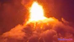
Guatemalan emergency management officials have declared an orange alert—the nation’s second-highest emergency level—following a sudden surge in activity at the highly active Fuego volcano. Located at the intersection of the Escuintla, Chimaltenango, and Sacatepéquez departments, the stratovolcano began spewing ash and showing signs of heightened instability on Monday, prompting immediate action from local authorities.
In response to the escalating threat, emergency services coordinated the evacuation of approximately 400 residents from high-risk communities situated near the volcano’s slopes. Evacuees have been relocated to temporary shelters established in Alotenango and Escuintla city. To ensure public safety, local officials have also suspended classes at nearby schools, citing the immediate dangers of heavy ash fall and potential pyroclastic flows.
The memory of Fuego’s devastating 2018 eruption, which claimed hundreds of lives and buried entire villages, remains a driving force behind the rapid precautionary measures. Authorities are urging all residents in the surrounding areas to heed evacuation orders without delay, emphasizing that early relocation is critical to preventing another tragedy.
Fuego volcano is situated just 16 kilometers (10 miles) west of Antigua, a major tourist destination celebrated for its colonial-era architecture and designated as a UNESCO World Heritage Site. While the volcano is a popular attraction for international hikers, its current volatile state has forced a halt to recreational activities in the area as scientists closely monitor the eruption’s progression.
Key Takeaways
- Guatemalan authorities raised the emergency level to an 'orange alert' due to increased activity at the Fuego volcano.
- Approximately 400 residents have been evacuated to temporary shelters, and local schools have been closed to protect students from ash fall.
- The volcano is located near the historic tourist city of Antigua, raising concerns for both local communities and the region's travel sector.
Editor’s Analysis & Impact
The sudden escalation of activity at the Fuego volcano underscores the persistent geological risks faced by Guatemala, particularly within its vital tourism sector. Antigua, a UNESCO World Heritage Site located just miles from the peak, serves as an economic engine driven by international travelers and adventure tourism. Disruptions of this scale threaten local hospitality businesses, guide services, and regional transport networks. Furthermore, the proactive evacuation strategy reflects a significant evolution in Guatemala’s disaster response framework since the catastrophic 2018 eruption. By prioritizing early warnings and rapid relocation, emergency management agencies aim to mitigate loss of life, though prolonged activity could strain municipal resources and disrupt agricultural output in the fertile volcanic valleys surrounding the peak.
Frequently Asked Questions
Q: Where is the Fuego volcano located?
A: The Fuego volcano is situated in Guatemala, spanning the borders of the Escuintla, Chimaltenango, and Sacatepéquez regions, approximately 16 kilometers (10 miles) west of the historic city of Antigua.
Q: What safety measures have authorities taken in response to the eruption?
A: Guatemalan officials have declared an orange alert, evacuated around 400 residents to temporary shelters in Alotenango and Escuintla, and closed local schools due to the threat of ash fall.
Q: Why is this volcano considered particularly dangerous?
A: Fuego is an active stratovolcano with a history of violent eruptions, including a devastating event in 2018 that resulted in hundreds of casualties.
AI Disclosure: This article is based on verified data and official reports. Our Team and AI have cross-referenced every financial detail with primary sources to ensure total accuracy.
More from this Category