Unraveling the Devastating Journey of Nepal-Tibet Flash Flood
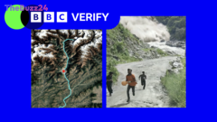
An in-depth investigation has meticulously reconstructed the trajectory of a catastrophic flash flood that swept through Nepal and Tibet, resulting in significant loss of life. Utilizing a combination of authenticated video footage and advanced satellite imagery, the investigative team has pieced together the flood’s destructive path, offering crucial insights into its origins and progression.
The analysis reveals the complex dynamics of the disaster, highlighting how the initial event in the mountainous terrain of Tibet rapidly escalated into a widespread inundation affecting downstream communities in Nepal. The detailed tracing provides a clearer understanding of the geographical factors and the speed at which the floodwaters traveled, underscoring the vulnerability of the region to such extreme weather events.
This comprehensive reconstruction is vital for disaster preparedness and response efforts. By understanding the precise sequence of events and the contributing factors, authorities and aid organizations can better anticipate future risks, develop more effective early warning systems, and implement targeted mitigation strategies to protect populations in similar geologically sensitive areas. The findings underscore the interconnectedness of environmental changes and their profound impact on human settlements.
Key Takeaways
- A detailed investigation has mapped the path of a deadly flash flood in Nepal and Tibet using video and satellite data.
- The flood's progression from Tibet to Nepal has been reconstructed, revealing its rapid and destructive nature.
- The findings are crucial for improving disaster preparedness, early warning systems, and mitigation strategies in vulnerable regions.
Editor’s Analysis & Impact
This investigative report into the Nepal-Tibet flash flood offers a critical case study in the escalating impacts of extreme weather events, likely exacerbated by climate change. The detailed tracing of the flood’s path provides invaluable data for understanding hydrological risks in mountainous regions. Such precise analysis is essential for developing resilient infrastructure and effective early warning systems, particularly in areas prone to glacial lake outburst floods or heavy monsoon rainfall. The broader implication is a heightened need for cross-border cooperation on environmental monitoring and disaster management to safeguard communities against increasingly frequent and severe natural calamities.
Frequently Asked Questions
Q: What methods were used to trace the flash flood's path?
A: The path of the flash flood was traced using a combination of verified video footage and satellite imagery.
Q: Why is tracing the path of a flash flood important?
A: Tracing the path is crucial for understanding the flood's dynamics, improving disaster preparedness, developing early warning systems, and implementing effective mitigation strategies to protect vulnerable populations.
Q: What regions were affected by this flash flood?
A: The flash flood originated in Tibet and subsequently affected areas in Nepal.
AI Disclosure: This article is based on verified data and official reports. Our Team and AI have cross-referenced every financial detail with primary sources to ensure total accuracy.
More from this Category