Pacific Marine Air Blankets Northwest in September Fog and Stratus
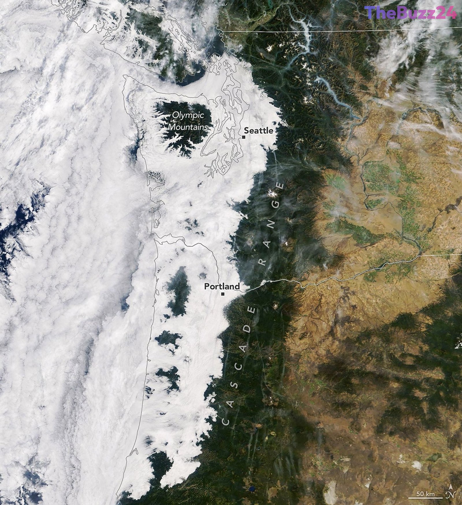
A significant influx of cool marine air pushing inland from the Pacific Ocean created a striking blanket of morning clouds across western Washington and Oregon in mid-September 2026. Satellite imagery captured the extensive low-lying stratus clouds and dense fog stretching all the way to the western foothills of the Cascade Range. Meanwhile, higher terrain features such as the Olympic Mountains in Washington and the Oregon Coast Range pierced through the cloud deck, creating an island-like visual effect above the atmospheric blanket.
The widespread cloud cover was documented by the MODIS instrument aboard the Terra satellite, highlighting the dense fog and marine stratus that developed following consecutive nights of onshore airflow. Meteorologists explain that these cloud layers typically form when moist surface air becomes trapped beneath a warmer upper air layer during a temperature inversion. As the near-surface air cools, the trapped water vapor condenses into extensive low-level clouds, occasionally reducing visibility at ground level and creating widespread morning fog.
While the morning hours were dominated by the heavy marine layer, afternoon conditions shifted significantly as daytime heating took effect. Satellite observations from the Aqua satellite later that afternoon showed that skies had cleared across the majority of the inland valleys. However, residual marine clouds continued to hug portions of the Oregon coastline, maintaining cooler local temperatures compared to the warmer inland regions where solar radiation successfully burned off the morning fog.
Key Takeaways
- Cool marine air from the Pacific Ocean generated a widespread layer of morning clouds and fog across western Washington and Oregon.
- Higher peaks, including the Olympic Mountains and the Oregon Coast Range, protruded above the dense cloud deck like islands.
- Afternoon heating allowed skies to clear significantly across inland areas, though lingering marine clouds persisted along the immediate coast.
Editor’s Analysis & Impact
The meteorological event highlights the intricate dynamics of regional coastal weather patterns and the vital role of satellite remote sensing in tracking atmospheric phenomena. Understanding marine layer dynamics is crucial not only for local forecasting, aviation, and daily commuting, but also for analyzing broader climatic trends related to coastal temperature gradients and regional ecology. As satellite technology advances, meteorologists gain unprecedented precision in monitoring these fleeting microclimates, offering deeper insights into how ocean-atmosphere interactions shape local environments in the Pacific Northwest.
Frequently Asked Questions
Q: What causes marine layer clouds to form in the Pacific Northwest?
A: Marine layer clouds form when cool, moist air from the ocean flows inland and gets trapped beneath a warmer layer of air in a temperature inversion, causing water vapor to condense into low-lying stratus clouds and fog.
Q: How long do these morning marine clouds typically last?
A: While they often create dense overcast skies and fog during the morning hours, these clouds frequently dissipate by the afternoon as daytime heating and solar radiation clear the skies over inland areas.
AI Disclosure: This article is based on verified data and official reports. Our Team and AI have cross-referenced every financial detail with primary sources to ensure total accuracy.
More from this Category