Martian Geometry: Curiosity Uncovers Intriguing Polygonal Formations as Mount Sharp Ascent Resumes
Following several productive weeks dedicated to deep drilling and compositional analysis at the “Basque Lakes” and “Nazca” sites, NASA’s Curiosity rover has resumed its journey up the slopes of Mount Sharp. The robotic explorer is now setting its sights on the higher-elevation Yardang unit, using its suite of remote sensing and contact instruments—including Mastcam, ChemCam, APXS, and MAHLI—to examine Martian rock textures and chemical signatures along the route without halting its upward drive.
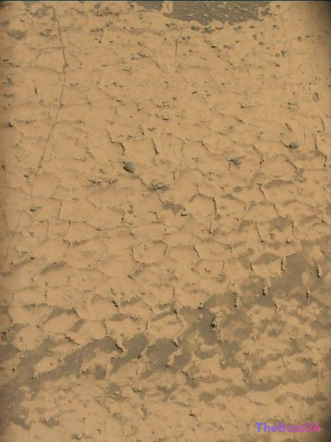
During its recent trek, Curiosity arrived at a striking terrain characterized by rocks crisscrossed with regular, small-scale polygonal patterns bounded by prominent raised ridges. This distinctive network closely resembles an enigmatic geological feature observed at lower elevations on Mount Sharp several months ago. The repetition of these geometric structures has captured the attention of mission scientists seeking to unravel the ancient environmental conditions that shaped them.
Such polygonal textures typically develop under specific physical and chemical regimes, including surface shrinkage from the dehydration of water-bearing minerals, intense thermal cycling, or complex subsurface burial and compaction cycles. Detailed observations gathered during this phase will help identify the mineral composition of the cementing agents holding the raised ridges together, shedding light on the historical presence of liquid water and the geochemical evolution of the Martian surface.
Orbital mapping of the terrain ahead suggests that Curiosity will encounter increasingly vast and pronounced fields of these polygonal features in the coming drives. Having surpassed 5,000 sols of active operations on the Red Planet, the rover continues to provide critical ground-truth data that challenges and refines our understanding of Mars’ dynamic past.
Key Takeaways
- Curiosity has concluded drilling at the Basque Lakes and Nazca sites to resume its ascent toward Mount Sharp's Yardang unit.
- The rover observed distinctive, ridge-bordered polygonal rock patterns that hint at historical wetting, drying, and mineral cementation processes.
- Orbital reconnaissance indicates that expansive fields of these geometric features lie directly in Curiosity’s upcoming path.
Editor’s Analysis & Impact
Curiosity’s ongoing documentation of polygonal rock patterns illustrates the immense scientific dividend delivered by long-duration planetary exploration missions. Even after operating for more than 5,000 Martian sols, the rover continues to discover localized formations that illuminate the environmental evolution of Mars. Polygonal networks formed by mineral dehydration or thermal contraction are pivotal indicators of past aqueous activity. Understanding the cementation mechanisms within these ridges gives researchers a clearer timeline of when liquid water receded and how habitability conditions changed over time. These observations not only deepen our understanding of Martian sedimentology but also refine the criteria scientists use to interpret orbital data across other regions of the planet.
Frequently Asked Questions
Q: What causes polygonal rock patterns on Mars?
A: Polygonal textures typically form through physical processes such as the contraction and cracking of drying, water-saturated minerals, intense seasonal temperature shifts, or subsurface compaction followed by exposure.
Q: Why did Curiosity pause its journey before investigating these formations?
A: The rover spent several weeks stationary to drill and conduct chemical analysis on core samples extracted from the 'Basque Lakes' and 'Nazca' targets before hitting the road again.
Q: What is the primary objective of Curiosity's current drive?
A: Curiosity is climbing toward the Yardang unit on Mount Sharp to study how different rock layers and textures reflect major transitions in Mars' ancient climate and potential habitability.
AI Disclosure: This article is based on verified data and official reports. Our Team and AI have cross-referenced every financial detail with primary sources to ensure total accuracy.
More from this Category