A Piece of the Moon in Madagascar: ISS Captures Stunning Image of Ancient Geological Massif
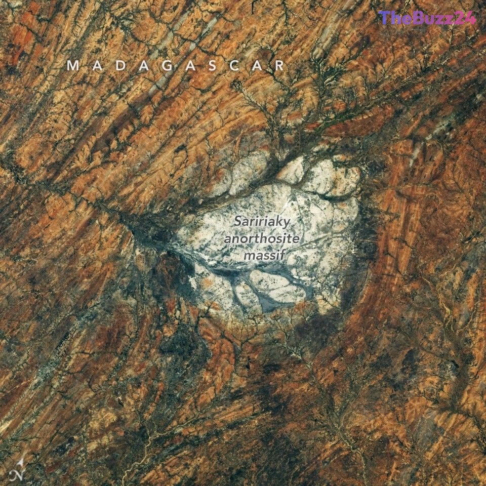
A striking geological feature in the arid southern region of Madagascar has captured the attention of researchers and space explorers alike. Photographed from the International Space Station by the Expedition 75 crew, the Saririaky anorthosite massif stands out as a highly reflective, light-colored patch of rock. This unique formation bears a striking resemblance to the lunar highlands, which are composed of the same igneous rock, anorthosite, and are visible from Earth with the naked eye.
The Saririaky massif is an intrusive igneous rock formation that crystallized from magma deep beneath the Earth’s surface at least 600 million years ago during the late Precambrian era. Spanning approximately 100 square kilometers, the massif is situated within a ductile shear zone. This region underwent intense heat and pressure, which deformed and reshaped the surrounding rock into distinct north-south linear patterns. Geologists believe these dramatic changes occurred during the tectonic collisions that assembled the ancient supercontinent of Gondwana, which once united Africa, India, Madagascar, Australia, and Antarctica.
Beyond its earthly geological significance, the Madagascar massif serves as a vital analog for planetary scientists studying the Moon. While lunar anorthosites are over four billion years old—having formed the Moon’s outer crust as its primordial magma ocean cooled—samples brought back by Apollo missions are extremely scarce. By studying terrestrial counterparts like the Saririaky massif and similar formations in the Beartooth Mountains of Montana, researchers can gain deeper insights into the early history and volcanic evolution of our closest celestial neighbor.
Key Takeaways
- The International Space Station captured high-resolution imagery of the Saririaky anorthosite massif in southern Madagascar, a rock formation that closely mirrors the composition of the Moon's highlands.
- Dating back at least 600 million years, the 100-square-kilometer massif was reshaped by immense tectonic forces during the formation of the ancient supercontinent Gondwana.
- Terrestrial anorthosite formations provide scientists with crucial, accessible analogs to study lunar geology, supplementing the limited rock samples collected during the Apollo missions.
Editor’s Analysis & Impact
The discovery and ongoing study of terrestrial lunar analogs like Madagascar’s Saririaky massif highlight a growing trend in planetary geology: leveraging Earth’s unique formations to prepare for the next era of space exploration. As humanity prepares for sustained lunar missions under programs like Artemis, understanding the Moon’s crustal composition is more critical than ever. Terrestrial analogs offer a cost-effective, highly accessible laboratory for testing geological instruments, training astronauts in field geology, and refining remote sensing technologies. Furthermore, this research underscores the interconnectedness of Earth’s tectonic history and broader solar system evolution. By studying how these ancient rocks survived tectonic shifts during the assembly of Gondwana, scientists can better model the crustal stability of airless bodies like the Moon, bridging the gap between Earth-bound geology and deep-space exploration.
Frequently Asked Questions
Q: What is anorthosite and why is it found on both Earth and the Moon?
A: Anorthosite is an intrusive igneous rock composed primarily of calcium-rich plagioclase feldspar. On the Moon, it formed the early crust as a magma ocean cooled over 4 billion years ago. On Earth, it forms when magma cools slowly beneath the surface, often appearing in ancient geological shields.
Q: How does the Saririaky massif help scientists study the Moon?
A: Because lunar rock samples collected by Apollo astronauts are extremely limited and difficult to obtain, scientists use Earth-based anorthosite formations like the Saririaky massif as physical stand-ins to study the mineral composition, weathering patterns, and reflective properties of lunar highlands.
Q: When and how did the Saririaky massif form?
A: The massif formed at least 600 million years ago during the late Precambrian era. It was later deformed and reshaped by intense heat and pressure within a shear zone during the tectonic collisions that created the supercontinent Gondwana.
AI Disclosure: This article is based on verified data and official reports. Our Team and AI have cross-referenced every financial detail with primary sources to ensure total accuracy.
More from this Category