Astronaut Captures Stunning Pre-Dawn Glow Over America’s Heartland
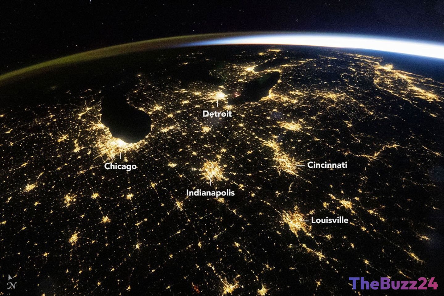
An astronaut aboard the International Space Station (ISS) recently captured a breathtaking wide-angle photograph of the eastern United States in the predawn hours of October 18, 2026. The image, taken at 4:54 a.m. Central Daylight Time, showcases a vast network of illuminated cities and towns spread across the darkened landscape, offering a unique perspective on human activity from orbit.
The sprawling metropolitan areas of Chicago, Illinois, and Detroit, Michigan, are prominent bright spots in the photograph, serving as beacons in the night. Surrounding these major hubs, mid-sized cities such as Indianapolis, Indiana; Cincinnati, Ohio; and Louisville, Kentucky, also shine brightly, their lights interconnected by the visible patterns of state and interstate highways. This intricate web of urban illumination highlights the dense population and infrastructure of the American Midwest.
Adding to the celestial spectacle, a subtle band of green and orange light, known as airglow, is visible along the horizon. This natural phenomenon occurs when atoms and molecules in the upper atmosphere interact with sunlight, emitting photons. To the right of the frame, the approaching sunrise casts a warm glow, with dawn still about an hour away for the East Coast and approximately two hours away for Chicago.
These astronaut-captured images of nighttime lights are more than just visually striking; they are scientifically invaluable tools. Researchers utilize these observations, along with data from satellite sensors like NASA’s Black Marble nighttime lights product suite, to track changes in the built environment. By analyzing the brightness, color, and extent of urban lights, scientists can gain insights into urban growth patterns, monitor the impact of infrastructure development, assess power restoration after natural disasters, and even identify transitions in lighting technologies, such as the shift to LEDs.
Key Takeaways
- An astronaut on the ISS photographed the illuminated eastern U.S. in the pre-dawn hours of October 18, 2026.
- The image highlights major and mid-sized cities, along with highway networks, showcasing human settlement patterns.
- Nighttime light imagery from space is a valuable scientific tool for tracking urban development and environmental changes.
Editor’s Analysis & Impact
This stunning image underscores the growing importance of remote sensing in understanding our planet. The ability to analyze nighttime lights from orbit provides critical data for urban planning, disaster response, and monitoring environmental impacts. As cities continue to expand and lighting technologies evolve, these orbital perspectives offer an objective measure of human activity and its footprint. The data derived from such observations can inform policy decisions, resource management, and our broader understanding of global development trends, making these images essential for both scientific research and public awareness.
Frequently Asked Questions
Q: What is airglow?
A: Airglow is a natural phenomenon where the upper atmosphere emits faint light. It is caused by chemical reactions that occur when atoms and molecules in the atmosphere are energized, often by sunlight, and then release that energy as photons.
Q: How are nighttime lights from space scientifically useful?
A: Nighttime lights observed from space, particularly through satellite data like NASA's Black Marble product, are used to track urban growth, monitor economic activity, assess damage and recovery after natural disasters (like power outages), and study changes in lighting technology (e.g., the adoption of LEDs). They provide a consistent, large-scale view of human presence and development.
Q: What technology was used to capture the astronaut photograph?
A: The photograph was captured using a Nikon Z9 digital camera with a 14-millimeter focal length.
AI Disclosure: This article is based on verified data and official reports. Our Team and AI have cross-referenced every financial detail with primary sources to ensure total accuracy.
More from this Category