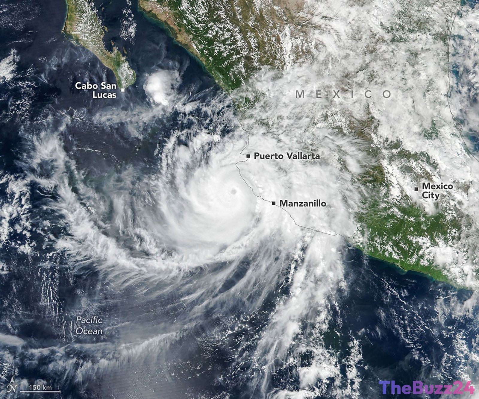
Category 4 Hurricane Simon Lashes Mexican Coast, Posing Unpredictable Threat
Hurricane Simon, a formidable Category 4 storm, churned off Mexico’s Pacific coast on October 11, 2026, marking another significant event in an already active Eastern Pacific tropical cyclone season. With sustained winds reaching a staggering 250 kilometers (155 miles) per hour, the powerful system crept north-northwest, bringing its destructive potential perilously close to densely populated coastal regions.
Satellite imagery captured the hurricane’s immense scale as its eye passed approximately 50 kilometers (30 miles) offshore, positioned between the key port city of Manzanillo and the popular tourist destination of Puerto Vallarta. At this critical juncture, sustained winds were estimated at 210 kilometers (130 miles) per hour, with the storm’s inner core brushing against the coastline. The rugged topography of the Sierra Madre mountains appeared to exert an influence, somewhat tempering the storm’s intensity and reducing the size of its expansive wind field. Despite this, Simon unleashed torrential rainfall and widespread flooding across coastal areas, including Manzanillo, and significantly elevated the risk of dangerous mudslides in the mountainous terrain.
Beyond its immediate surface impact, Hurricane Simon also created fascinating atmospheric phenomena. Nighttime satellite observations on October 11 revealed atmospheric gravity waves radiating from the hurricane, visible through mesospheric airglow. These ripples are generated by the intense convection and latent heat release within the storm’s eyewall, propelling waves into the upper atmosphere. The visibility of these waves was aided by minimal moonlight, which typically can obscure the faint airglow.
As of October 13, meteorologists faced “very low confidence” in predicting Simon’s continued evolution and precise trajectory. The storm’s behavior continued to defy conventional expectations, with a potential path steering it north into the Gulf of California before any eventual landfall. Coastal communities along Mexico’s southwestern and west-central regions were advised to brace for large swells and hazardous nearshore conditions in the days that followed, underscoring the persistent and unpredictable threat posed by the hurricane.
Key Takeaways
- Hurricane Simon, a Category 4 storm, brought significant threats to Mexico's Pacific coast, including heavy rain, flooding, and mudslides.
- The storm's interaction with the Sierra Madre mountains influenced its intensity and wind field, while also generating observable atmospheric gravity waves.
- Forecasting Simon's future path and intensity remained highly uncertain, with a potential trajectory into the Gulf of California and continued dangerous coastal conditions.
Editor’s Analysis & Impact
Hurricane Simon’s unpredictable behavior and significant impact on Mexico’s Pacific coast highlight the growing challenges posed by extreme weather events. The disruption to major port cities like Manzanillo can have immediate economic repercussions, affecting trade, supply chains, and local industries, including tourism and agriculture. The “low confidence” in forecasting underscores the critical need for advanced meteorological modeling and real-time satellite data, especially when storms interact with complex geographical features like mountain ranges. Looking ahead, the increasing frequency and intensity of such storms, potentially linked to climate change, necessitate greater investment in resilient infrastructure, robust emergency management protocols, and community preparedness to mitigate future economic and human costs.
Frequently Asked Questions
Q: What was Hurricane Simon's peak intensity near Mexico?
A: Hurricane Simon reached Category 4 strength with sustained winds up to 250 kilometers (155 miles) per hour as it passed close to Mexico's Pacific coast on October 11, 2026.
Q: How did the local geography affect Hurricane Simon?
A: The Sierra Madre mountains along the Mexican coast appeared to temper Hurricane Simon's intensity and reduce the size of its wind field as the storm's inner core brushed against the land.
Q: Why were forecasts for Hurricane Simon so uncertain?
A: Meteorologists reported "very low confidence" in predicting Simon's future path and intensity because the storm's evolution continued to defy expectations, making its trajectory, including a potential entry into the Gulf of California, difficult to forecast accurately.
AI Disclosure: This article is based on verified data and official reports. Our Team and AI have cross-referenced every financial detail with primary sources to ensure total accuracy.
More from this Category