Comparing Historical Climates: How the 2026 El Niño Parallels the Historic 1997 Event
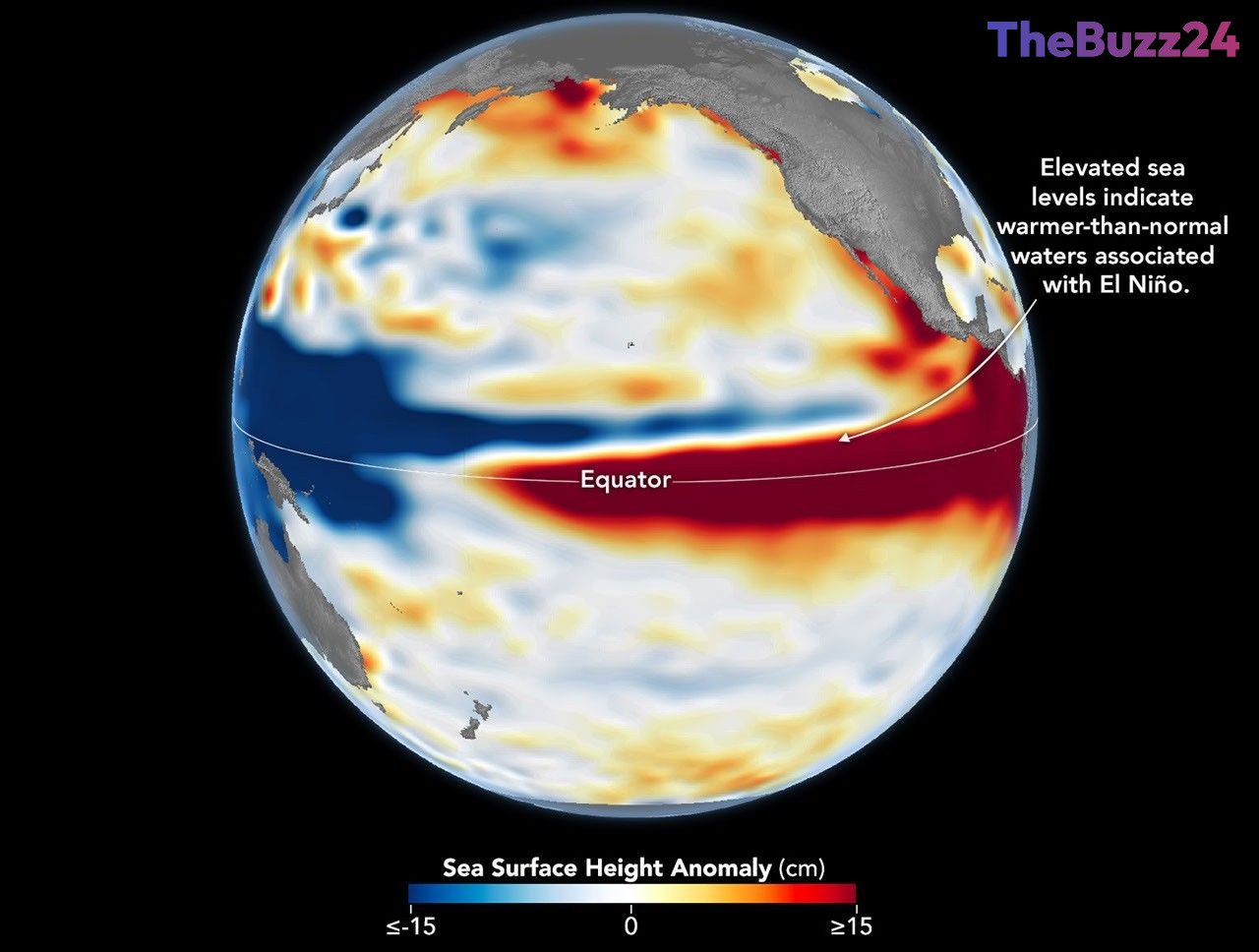
Recent satellite altimetry data reveals that sea levels across the central and eastern equatorial Pacific are significantly higher than normal, echoing the atmospheric and oceanic patterns seen during the legendary 1997-98 El Niño. Scientists tracking ocean surface topography note that the current climate phenomenon has developed rapidly, showing striking similarities to past heavy-hitting events that drastically altered global weather systems.
El Niño is a naturally occurring climate cycle driven by a complex feedback loop between warming ocean waters and weakening trade winds. As trade winds slacken, vast pools of warm water migrate eastward across the Pacific, expanding the ocean surface and elevating sea levels. While each iteration of El Niño possesses unique regional characteristics dictated by where subsurface heat accumulates, modern satellite technology provides a multi-decade observational archive allowing researchers to draw direct parallels between contemporary warming events and their historical predecessors.
Although the onset of the current El Niño arrived much more abruptly than its 1997 counterpart, its overall structural tilt and high, warm water extending toward South America suggest a comparable trajectory. Meteorological forecasts indicate a high probability for a strong-to-very strong event to persist into the upcoming months. However, experts emphasize that while historical baselines provide a valuable forecasting lens, the chaotic nature of the global atmosphere means regional weather impacts will carry their own distinct footprint.
Key Takeaways
- Satellite altimetry data shows current Pacific sea levels mirroring the massive 1997-98 El Niño event.
- The 2026 climate pattern developed much more suddenly than historical counterparts while maintaining similar structural characteristics.
- Advanced ocean-observing satellites provide a 35-year continuous record to track and compare these complex oceanic heat shifts.
Editor’s Analysis & Impact
The recurrence of strong El Niño cycles highlights the critical importance of continuous satellite Earth observation in predicting severe weather anomalies. As global sea surface temperatures fluctuate, industries heavily reliant on accurate long-range weather forecasting—such as agriculture, insurance, shipping, and disaster management—must adapt to increasingly volatile climate trends. Understanding these historical parallels helps model future climate resilience, allowing governments and corporations to better prepare for widespread disruptions like droughts, floods, and shifting agricultural yields across vulnerable global regions.
Frequently Asked Questions
Q: What is an El Niño event?
A: El Niño is a natural climate cycle that occurs every two to seven years, characterized by warmer-than-average water pooling in the central and eastern equatorial Pacific Ocean, significantly altering global weather patterns.
Q: How do satellites track El Niño?
A: Satellites use altimetry technology to measure the height of the sea surface. Because water expands as it warms, elevated sea levels indicate a buildup of subsurface heat associated with El Niño.
Q: Why is comparing the 2026 El Niño to 1997 important?
A: Comparing current anomalies to the severe 1997-98 event helps scientists forecast potential impacts on global weather, including precipitation levels and drought risks, based on a well-documented historical baseline.
AI Disclosure: This article is based on verified data and official reports. Our Team and AI have cross-referenced every financial detail with primary sources to ensure total accuracy.
More from this Category