Former Hurricane Isaias Unleashes Record-Setting Extratropical Cyclone on Iceland
The remnants of Hurricane Isaias, the sole Atlantic hurricane to date in 2026, underwent a dramatic transformation after making landfall in Florida as a Category 2 storm on October 9. Following its initial impact on the U.S. Gulf Coast and Eastern Seaboard, the weather system journeyed eastward across the North Atlantic, propelled by the jet stream. During this transoceanic passage, Isaias’s residual energy coalesced into a formidable extratropical cyclone, a low-pressure system characterized by its distinctive asymmetrical, comma-shaped cloud patterns and the capacity to unleash hurricane-force winds, torrential rain, and blizzard-like conditions.
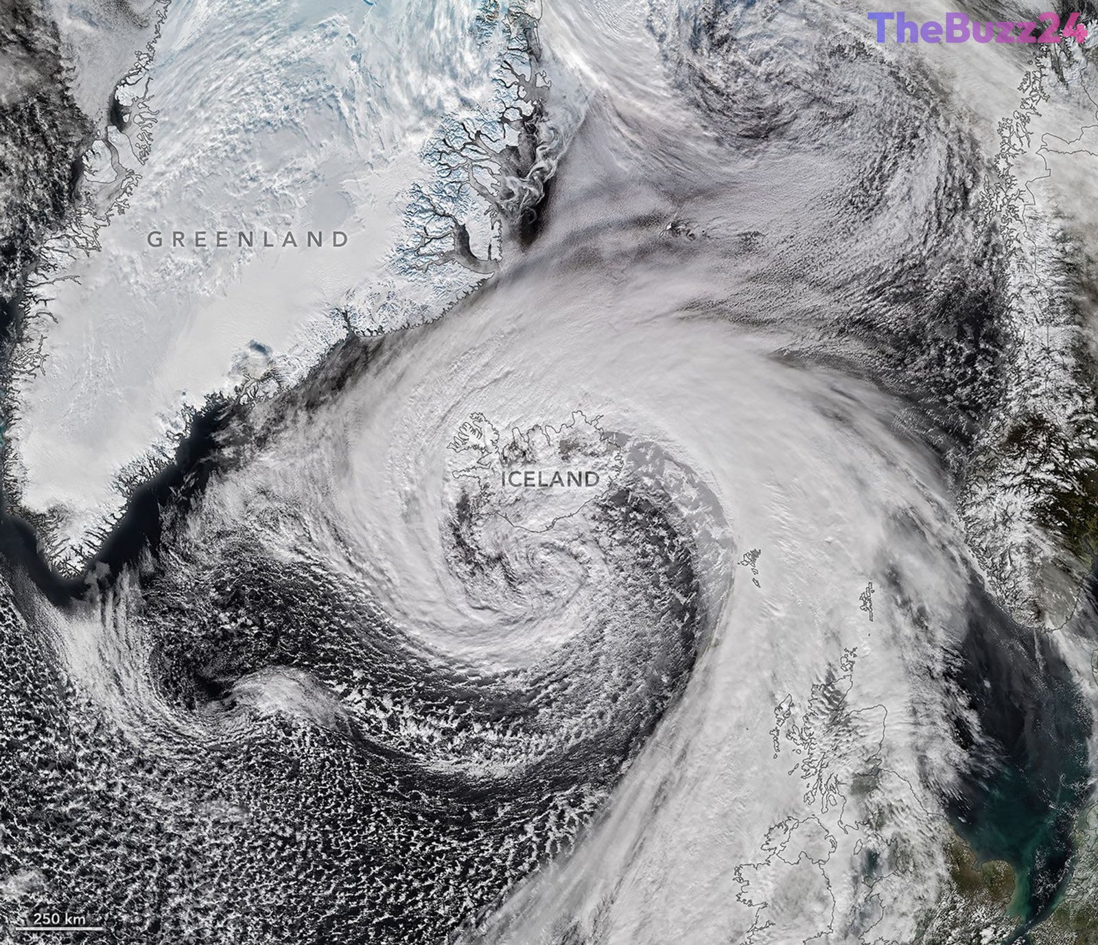
On the afternoon of October 14, satellite imagery captured by the Visible Infrared Imaging Radiometer Suite (VIIRS) on the NOAA-21 satellite revealed the powerful extratropical cyclone as it swept past Iceland. The storm exhibited an astonishing intensification, with its air pressure plummeting by more than 50 hectopascals over a 24-hour period. This rapid pressure drop is approximately double the threshold required for “explosive cyclogenesis,” a phenomenon commonly known as bombogenesis. Meteorologists are investigating whether this event established a new October low for barometric pressure in Iceland, potentially surpassing a record that has stood since 1963, after accounting for altitude corrections.
The cyclone delivered a severe blow to Iceland’s coastal regions, bringing with it exceptionally high winds. A staggering gust of 205 kilometers (128 miles) per hour was recorded near the Eyjafjallajökull volcano in southern Iceland, while a small island just offshore experienced sustained winds of 150 kilometers (93 miles) per hour. The damaging winds extended into the northern parts of the country, where residents also braced for a combination of sleet and snow. The storm’s influence was felt even further afield, with northwestern Scotland reporting gusts up to 90 kilometers (55 miles) per hour on October 14, leading to the cancellation of several ferry services across the region.
Key Takeaways
- Hurricane Isaias's remnants transformed into a powerful extratropical cyclone after crossing the Atlantic, impacting Iceland and Scotland.
- The cyclone underwent 'bombogenesis,' with its pressure dropping over 50 hectopascals in 24 hours, potentially setting a new October barometric pressure record for Iceland.
- Iceland experienced extreme winds, including gusts up to 205 km/h near Eyjafjallajökull, leading to widespread disruption and ferry cancellations in Scotland.
Editor’s Analysis & Impact
This event underscores the dynamic and often unpredictable nature of post-tropical storm systems, highlighting their potential for rapid re-intensification into powerful extratropical cyclones. The ‘bombogenesis’ phenomenon observed here, with its dramatic pressure drop, poses significant challenges for forecasting and disaster preparedness, particularly in regions like Iceland and Scotland accustomed to severe weather. From an industry perspective, sectors reliant on maritime transport and outdoor infrastructure face increased risks, necessitating robust contingency planning. The broader implications point towards the need for continued advancements in satellite monitoring and atmospheric modeling to better predict such extreme weather events, which may become more frequent or intense in a changing climate. This incident serves as a critical case study for understanding the complex interplay between tropical and extratropical weather systems.
Frequently Asked Questions
Q: What is an extratropical cyclone?
A: An extratropical cyclone is a low-pressure weather system that forms outside of the tropics, typically characterized by its distinctive comma-shaped cloud patterns and the ability to produce strong winds, heavy rain, and sometimes blizzard conditions. Unlike tropical cyclones (hurricanes), they draw energy from horizontal temperature differences in the atmosphere.
Q: What is 'bombogenesis'?
A: Bombogenesis, or explosive cyclogenesis, refers to the rapid intensification of a mid-latitude cyclone. It occurs when a storm's central atmospheric pressure drops by at least 24 hectopascals (or millibars) within a 24-hour period, indicating a very fast strengthening of the storm system.
Q: How did Hurricane Isaias contribute to this event?
A: After Hurricane Isaias made landfall and weakened, its remnants traveled eastward across the North Atlantic. These remnants carried significant atmospheric energy and moisture, which, when interacting with the colder air and jet stream over the North Atlantic, provided the necessary ingredients for the system to re-organize and intensify into a powerful extratropical cyclone.
AI Disclosure: This article is based on verified data and official reports. Our Team and AI have cross-referenced every financial detail with primary sources to ensure total accuracy.
More from this Category