The Rising Threat of Alaskan Megatsunamis Driven by Climate Change
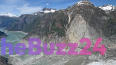
A massive geological event in an Alaskan fjord has underscored the escalating dangers posed by climate-induced landslides. Last summer, a staggering 64 million cubic meters of rock—a volume comparable to 24 Great Pyramids—collapsed into Tracy Arm Fjord in less than sixty seconds. The resulting displacement triggered a megatsunami that reached a height of nearly 500 meters, causing widespread environmental devastation, including the complete stripping of vegetation and the uprooting of ancient forests along the shoreline.
Researchers investigating the aftermath noted that the event occurred during the early morning, narrowly missing cruise ships that frequently traverse the area. The unique topography of Alaska, defined by steep, unstable mountain slopes and narrow fjords, creates a high-risk environment for such disasters. Scientists have linked the increasing frequency of these landslides directly to climate change; as glaciers retreat, they remove the essential structural support that once held cliff faces in place, leaving the terrain increasingly volatile.
Data indicates that the occurrence of these megatsunamis has surged tenfold in recent decades, prompting urgent calls for better hazard monitoring. As tourism continues to expand into these remote, sensitive regions, the intersection of public safety and environmental instability has become a critical concern. In response, some cruise operators have proactively modified their travel routes to bypass high-risk zones, reflecting a growing industry awareness of the need to balance exploration with the realities of a rapidly changing climate.
Key Takeaways
- A massive landslide in an Alaskan fjord triggered a 500-meter-high megatsunami, the second-tallest ever recorded.
- Glacial retreat caused by climate change is destabilizing mountain slopes, leading to a tenfold increase in landslide frequency.
- The tourism industry is beginning to adjust cruise routes to avoid high-risk areas as safety concerns mount.
Editor’s Analysis & Impact
The Alaskan megatsunami serves as a stark indicator of how climate change is physically reshaping the Earth’s surface. The correlation between glacial retreat and slope instability is not merely a localized geological issue but a systemic risk for industries operating in high-latitude regions. From an economic perspective, this event forces a re-evaluation of the ‘adventure tourism’ model, which relies on accessing pristine, remote environments that are becoming increasingly hazardous. Future infrastructure and maritime logistics in these regions will likely require significant investment in real-time seismic and geological monitoring systems. As these events become more frequent, the insurance and risk-management sectors will face pressure to quantify these environmental threats, potentially leading to stricter regulations on maritime traffic in vulnerable fjords.
Frequently Asked Questions
Q: Why are Alaskan fjords becoming more prone to landslides?
A: As glaciers retreat due to climate change, they remove the physical support that previously stabilized steep cliff faces, making the rock slopes more susceptible to collapse.
Q: How are cruise operators responding to these geological risks?
A: Some cruise operators have begun adjusting their navigation routes to avoid known high-risk areas, such as Tracy Arm, to ensure the safety of passengers and crew.
AI Disclosure: This article is based on verified data and official reports. Our Team and AI have cross-referenced every financial detail with primary sources to ensure total accuracy.
More from this Category