Satellite Analysis Uncovers Extreme Ground Displacement After Devastating Venezuela Earthquakes
On June 24, 2026, northern Venezuela was struck by a powerful seismic event, beginning with a magnitude 7.2 earthquake, swiftly followed by a magnitude 7.5 mainshock less than a minute later. These twin quakes unleashed widespread destruction and tragic loss of life across the affected region, particularly impacting coastal cities like La Guaira and the capital, Caracas. The severity of the tremors prompted immediate scientific investigation into the precise movements of the Earth’s surface.
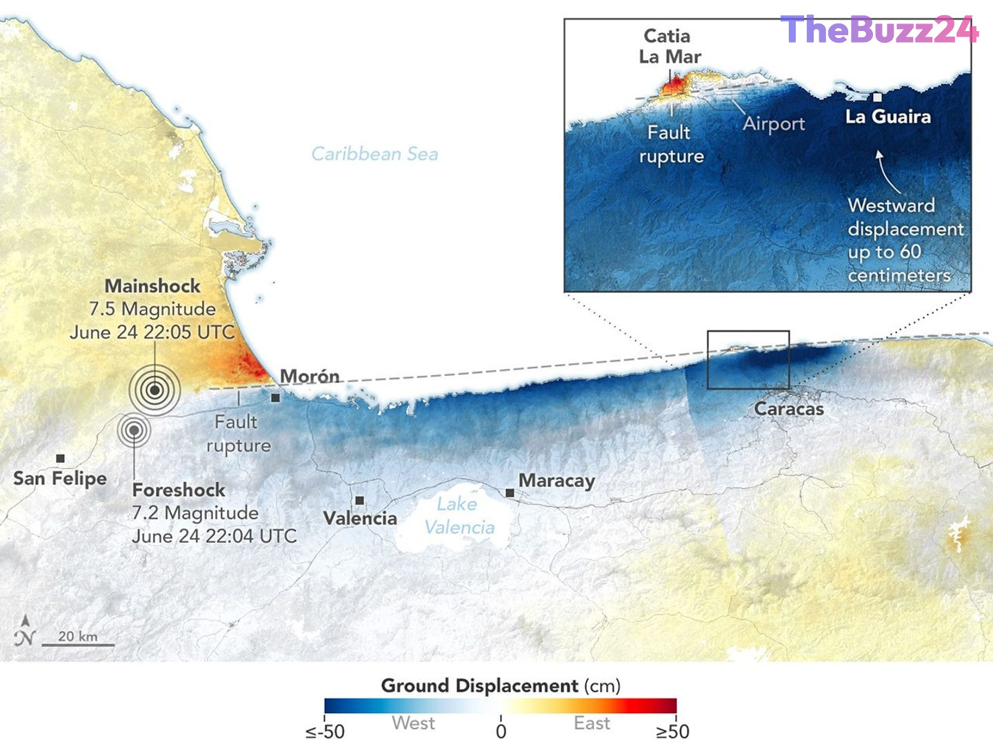
In the days following the disaster, advanced satellite technology provided critical insights into how the land surface shifted. Utilizing data from the NISAR (NASA-ISRO Synthetic Aperture Radar) satellite, scientists employed a technique known as Interferometric Synthetic Aperture Radar (InSAR). This method compares satellite images acquired before the earthquakes (June 13 and June 18) with those taken after (June 25 and June 30) to detect minute changes in ground elevation and horizontal movement. The resulting displacement maps highlighted areas of intense ground movement, with red indicating eastward and upward shifts, and blue denoting westward and downward motion.
The analysis revealed that most of the displacement was horizontal, consistent with a strike-slip fault event. A thin strip near Morón, where the fault likely ruptured at depth, showed minimal land displacement. The fault system responsible is part of a complex network situated along the boundary between the Caribbean plate to the north and the South American plate to the south, specifically believed to be within the San Sebastián fault system, possibly extending into the Boconó system. These fault lines have been accumulating significant strain over time. The rupture propagated offshore eastward before curving back onshore near the international airport north of Caracas. In this critical area, deep blue coloration on the maps indicated substantial westward surface displacement, reaching up to 60 centimeters (24 inches), a factor identified as contributing significantly to the extreme damage observed in Caracas and La Guaira.
Geophysicists have emphasized the invaluable nature of InSAR data in understanding the mechanics of such seismic events. The detailed displacement maps allowed the U.S. Geological Survey to refine its fault-slip model, providing a more accurate picture of how the fault slipped at depth, particularly along its eastern section. This enhanced understanding is crucial for assessing structural damage and informing future disaster preparedness. Notably, this event marked the first operational use of NISAR’s Urgent Response (UR) system to map surface displacement from a major earthquake, demonstrating its capability to deliver critical data within 12 to 24 hours to support immediate disaster response efforts.
Key Takeaways
- A magnitude 7.2 and 7.5 earthquake sequence struck northern Venezuela on June 24, 2026, causing extensive damage and loss of life, particularly in Caracas and La Guaira.
- Satellite data from NISAR, analyzed using InSAR, revealed significant ground displacement, with some areas near Caracas experiencing up to 60 centimeters of westward movement.
- The earthquakes occurred on a strike-slip fault system along the Caribbean and South American plate boundary, and the rapid data delivery from NISAR's Urgent Response system proved crucial for disaster assessment.
Editor’s Analysis & Impact
The immediate impact of these devastating earthquakes is on infrastructure, construction, and insurance sectors in Venezuela. The long-term implications could involve stricter building codes and increased investment in seismic-resistant construction. For the satellite imaging industry, this event highlights the growing demand for rapid, high-resolution data in disaster response, potentially driving innovation and investment in Earth observation technologies.
The successful deployment of NISAR’s Urgent Response system sets a precedent for future disaster management. This rapid data capability will likely become a standard tool for governments and aid organizations globally, improving the speed and accuracy of post-disaster assessments. It underscores the critical role of international collaboration in space technology for humanitarian efforts.
This event reinforces the ongoing seismic risk in plate boundary regions and the necessity for robust early warning and response systems. The detailed fault-slip models derived from such data will enhance our understanding of earthquake mechanics, potentially leading to better hazard mapping and risk mitigation strategies worldwide, ultimately saving lives and reducing economic losses from future seismic events.
Frequently Asked Questions
Q: How was the ground displacement measured?
A: Scientists used data from the NISAR (NASA-ISRO Synthetic Aperture Radar) satellite and a technique called Interferometric Synthetic Aperture Radar (InSAR). This method compares satellite images taken before and after the earthquakes to detect subtle changes in the ground's position.
Q: What was the significance of the NISAR Urgent Response system in this event?
A: This event marked the first time NISAR's Urgent Response (UR) system was used to map surface displacement from a large earthquake. It demonstrated the system's capability to deliver critical ground movement data within 12 to 24 hours, significantly aiding immediate disaster assessment and response efforts.
AI Disclosure: This article is based on verified data and official reports. Our Team and AI have cross-referenced every financial detail with primary sources to ensure total accuracy.
More from this Category