Satellite Imagery Captures Massive Dust Storm Over Mali
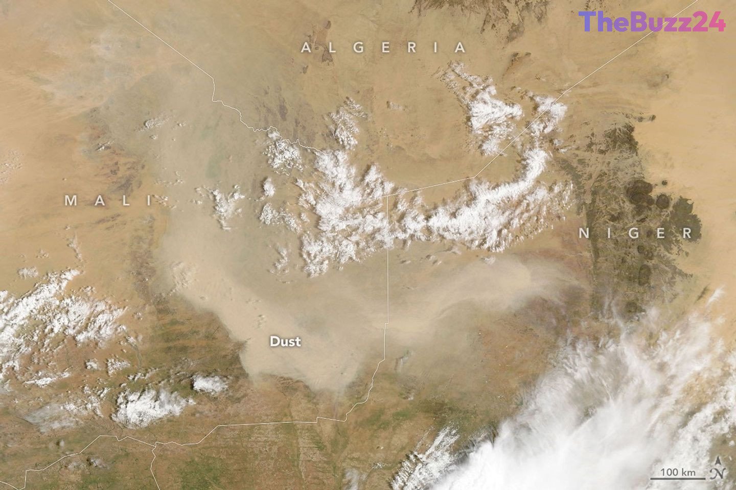
A significant dust storm swept across Mali in early September 2026, obscuring the landscape and highlighting the intense atmospheric activity that can still occur as the West African summer transitions into autumn. Satellite sensors captured the sprawling plume on September 5, revealing the scale of the event as it blanketed parts of the nation and extended into neighboring territories.
Atmospheric experts suggest that the event was likely a haboob, a type of powerful dust storm fueled by intense convective winds. While the immediate aftermath of the storm saw aerosols drifting westward toward the Atlantic Ocean, the plume did not complete a full transatlantic crossing. Such long-distance migrations are typically reserved for the peak of the Saharan Air Layer, which is most active during the late spring and summer months.
The occurrence of these storms remains a complex subject of study, particularly regarding how global climate phenomena like El Niño influence regional weather. While El Niño can shift the Intertropical Convergence Zone and alter convection patterns, its impact on dust activity is multifaceted. Drier conditions may increase the availability of loose sediment for wind transport, yet a simultaneous reduction in convective activity could potentially limit the frequency of the intense storms required to lift that dust into the atmosphere.
Key Takeaways
- A major dust storm, likely a haboob, was observed over Mali on September 5, 2026.
- While the dust moved toward the Atlantic, it did not complete a transatlantic crossing, which is more common earlier in the summer.
- Climate phenomena like El Niño create complex, competing effects on dust storm frequency by altering both sediment availability and convective wind patterns.
Editor’s Analysis & Impact
The observation of this dust storm underscores the ongoing volatility of the Sahelian climate. From an industry and environmental perspective, understanding these atmospheric events is critical for regional agriculture, air quality management, and aviation safety. The interplay between El Niño and local dust production highlights the difficulty in predicting extreme weather events in a changing climate. As global temperatures fluctuate, the shifting patterns of the Saharan Air Layer could have broader implications for Atlantic hurricane development and regional rainfall in West Africa. Future research will need to focus on how these convective-driven storms adapt to changing moisture levels, as the balance between sediment availability and storm-driving energy remains a key variable in long-term climate modeling for the region.
Frequently Asked Questions
Q: What is a haboob?
A: A haboob is a type of intense dust storm caused by strong convective winds, often associated with thunderstorm downdrafts that lift large amounts of sand and dust into the air.
Q: Why don't all dust storms from Africa cross the Atlantic?
A: Transatlantic dust transport usually requires the Saharan Air Layer to be active, which is most common from late spring through summer. Outside of this window, atmospheric conditions are often less favorable for carrying dust thousands of miles across the ocean.
AI Disclosure: This article is based on verified data and official reports. Our Team and AI have cross-referenced every financial detail with primary sources to ensure total accuracy.
More from this Category