Seattle from Above: How Glaciers and Human Engineering Sculpted the Emerald City
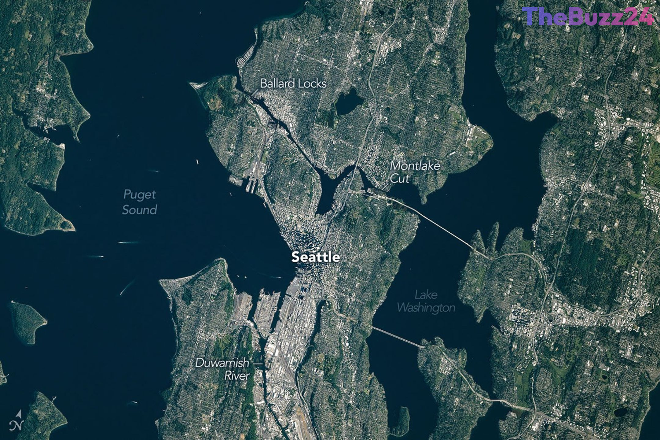
A striking photograph captured from the International Space Station on June 16, 2026, offers a unique perspective on Seattle, revealing the intricate interplay between the city’s natural glacial topography and its modern urban development. Known as the ‘Emerald City’ for its lush greenery and dense tree canopy, Seattle’s current landscape is a testament to both ancient geological forces and centuries of human intervention.
The region’s dramatic contours were primarily carved between 18,000 and 16,000 years ago by the Puget lobe of the Cordilleran ice sheet. This massive glacier, reaching depths of up to 3,300 feet, scoured the basins now occupied by Puget Sound and the city’s surrounding lakes. The legacy of this ice age remains visible today in the city’s distinctive hills—many of which are drumlins formed by glacial debris—and the presence of massive glacial erratics, such as the 20-foot-tall Wedgwood Rock, scattered throughout the area.
In the modern era, human engineering has further reshaped the environment. Major projects, including the leveling of Denny Hill and the filling of tideflats at the mouth of the Duwamish River, have expanded the city’s usable land by over 1,300 acres, providing the foundation for downtown infrastructure and professional sports stadiums. Furthermore, the early 20th-century construction of the Lake Washington Ship Canal and the Ballard Locks fundamentally altered the region’s hydrology, connecting freshwater lakes to the Pacific Ocean and permanently lowering the water level of Lake Washington.
Today, Seattle stands as a blend of these historical layers. While the city continues to modernize its waterfront with new terminals and public spaces, it maintains pockets of old-growth forest that support diverse wildlife. From the vantage point of space, the city appears as a vibrant hub where maritime commerce, recreational waterways, and dense urban development coexist within a landscape defined by its glacial past.
Key Takeaways
- Seattle's topography was fundamentally shaped by the Cordilleran ice sheet, which created the region's basins and drumlin-based hills.
- Human engineering, including the creation of the Ballard Locks and significant land reclamation projects, has drastically altered the city's natural waterways and shoreline.
- The city's 'Emerald City' moniker is supported by the preservation of old-growth forests within urban limits, which continue to host diverse wildlife populations.
Editor’s Analysis & Impact
The imagery of Seattle from the International Space Station serves as a powerful case study in urban geography and environmental history. By visualizing the intersection of glacial remnants and massive civil engineering projects, we gain insight into how cities are not merely built upon land, but are active participants in the ongoing evolution of their local ecosystems. The long-term implications of these landscape modifications—such as the rerouting of water systems and the filling of tideflats—highlight the tension between urban expansion and environmental stability. As climate change continues to influence sea levels and regional weather patterns, understanding the historical manipulation of these landscapes becomes essential for future urban planning, infrastructure resilience, and the preservation of the remaining natural habitats that define the city’s character.
Frequently Asked Questions
Q: Why is Seattle called the 'Emerald City'?
A: Seattle is nicknamed the 'Emerald City' due to its lush, green appearance, which is a result of its dense tree canopy, numerous parks, and the presence of old-growth forests within the city limits.
Q: How did the last ice age affect Seattle's geography?
A: The Cordilleran ice sheet scoured the region, creating the deep basins of Puget Sound and the local lakes, while also depositing glacial debris that formed the city's characteristic hills and large boulders known as erratics.
AI Disclosure: This article is based on verified data and official reports. Our Team and AI have cross-referenced every financial detail with primary sources to ensure total accuracy.
More from this Category