Swirling Ice and Sediment Plumes: Satellite Imagery Captures Dramatic Spring Thaw in the Bering Sea
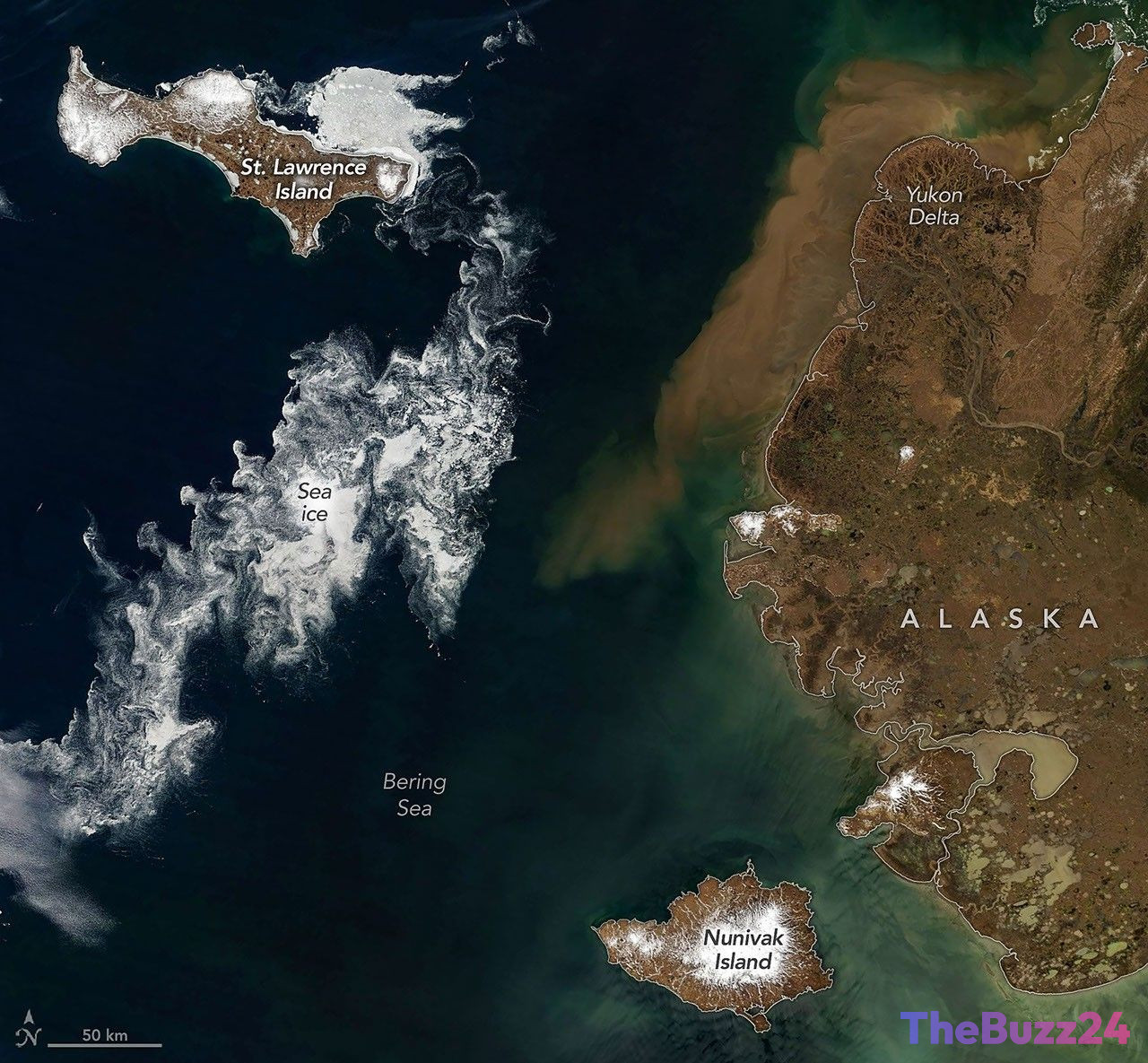
As summer approached in early June 2026, clear skies over the Bering Sea revealed a stunning seasonal transition along the Alaskan coast. Newly released satellite imagery captured the final stages of the winter freeze, showing sea ice fracturing into delicate, swirling patterns as it melted into the warming ocean. At the same time, rivers swollen with spring runoff began emptying massive volumes of sediment and organic matter into the coastal waters, painting the shoreline in rich shades of brown and teal.
The observations, recorded on June 3, 2026, by the Moderate Resolution Imaging Spectroradiometer (MODIS) aboard the Terra satellite, utilize both natural-color and false-color imaging to highlight these environmental shifts. In the false-color rendering, active melt zones become highly visible: lingering ice and snow glow in vibrant light blue, while the lush tundra and marshlands of mainland Alaska appear in deep green. The region’s ice-free rivers and thermokarst lakes stand out as dark blue bodies cutting through the thawing landscape.
Prominently featured in the region are Saint Lawrence and Nunivak islands, two of the largest volcanic islands in the United States. Saint Lawrence Island, positioned about 150 miles south of the Bering Strait, serves as a vital geographic remnant of the ancient Pleistocene land bridge that once connected Asia and North America. Satellite data showed pack ice clinging to the island’s northeastern shores, while smaller ice floes drifted away, creating intricate, wispy spirals driven by ocean currents and seasonal winds.
Further east, the vast wetlands of the Yukon Delta showed high concentrations of sediment flowing into the sea. This annual phenomenon occurs as rising temperatures melt river ice, allowing the Yukon River’s complex network of channels to carry eroded soil and dissolved organic material downstream. This influx of nutrients and sediment plays a critical role in the local marine ecosystem, marking the official commencement of the high-productivity summer season in the sub-Arctic.
Key Takeaways
- Satellite imagery from June 2026 captured the dramatic seasonal transition in the Bering Sea, characterized by melting sea ice and heavy river runoff.
- Saint Lawrence and Nunivak islands, both of volcanic origin, exhibited unique ice-drift patterns shaped by local winds and ocean currents.
- The Yukon Delta experienced its annual surge of sediment and organic matter, signaling the start of the highly productive sub-Arctic summer ecosystem cycle.
Editor’s Analysis & Impact
The rapid seasonal transition captured in the Bering Sea highlights the ongoing sensitivity of sub-Arctic ecosystems to global temperature fluctuations. The timing and scale of the spring thaw, particularly the breakup of sea ice and the volume of river runoff, serve as critical indicators for climatologists monitoring Arctic warming trends. From an ecological perspective, the massive influx of sediment and organic nutrients from the Yukon River into the Bering Sea is a vital driver of marine biodiversity, fueling plankton blooms that support regional fisheries. However, as global temperatures continue to rise, earlier thaws and reduced winter ice cover could disrupt these delicate ecological timelines. This shift poses potential challenges for local indigenous communities reliant on stable ice conditions for transport and hunting, while also altering the migratory patterns of marine life in one of the world’s most productive fishing grounds.
Frequently Asked Questions
Q: What causes the swirling patterns in the melting sea ice?
A: The swirling patterns are created by ocean currents and wind patterns acting on fragmented sea ice. As the ice breaks into smaller pieces, it becomes more susceptible to these physical forces, resulting in intricate, wispy formations visible from space.
Q: Why does the water around the Yukon Delta appear brown in the spring?
A: The brownish color is caused by a mixture of suspended sediment and dissolved organic matter. This material is carried downstream by the Yukon River after winter ice melts and spring rains erode the surrounding soil, washing nutrients into the sea.
Q: What is the historical significance of Saint Lawrence Island?
A: Saint Lawrence Island is one of the few remaining above-water remnants of the Bering Land Bridge (Beringia), which connected Asia and North America during the Pleistocene epoch, allowing humans and wildlife to migrate between the continents.
AI Disclosure: This article is based on verified data and official reports. Our Team and AI have cross-referenced every financial detail with primary sources to ensure total accuracy.
More from this Category