The Breathing Islands: How Daily Tides Reshape Guinea-Bissau’s Bijagós Archipelago
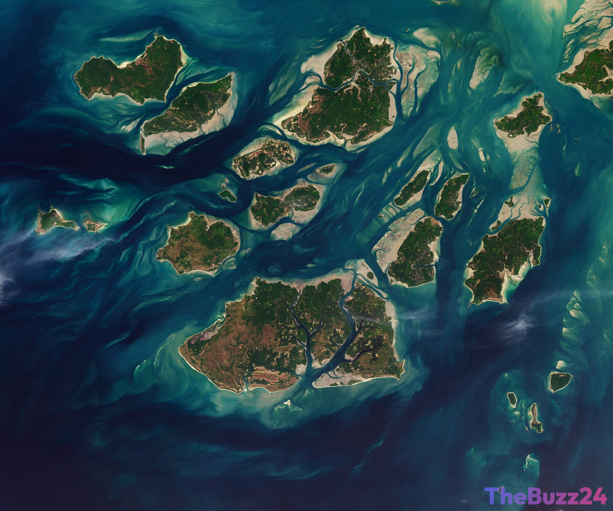
Off the coast of West Africa, the Bijagós Archipelago of Guinea-Bissau presents one of the most dynamic coastal environments on Earth. Comprising 88 islands and islets, this unique region undergoes a dramatic transformation twice every day. Driven by powerful ocean tides, water surges and retreats through a complex network of sandy channels, expansive mudflats, and dense mangrove forests, constantly reshaping the visible landmass.
Recent aerial observations highlight the stark visual contrast created by this tidal cycle. During low tide, vast stretches of intertidal mudflats and sandflats emerge from the Atlantic Ocean. This phenomenon temporarily expands the surface area of the islands, effectively making them “grow” in size. As the tide rushes back in hours later, these newly exposed lands are swallowed once more, shrinking the islands back to their high-tide boundaries.
Beyond its mesmerizing visual patterns, this shifting landscape plays a critical role in supporting a rich and diverse ecosystem. The intertidal zones serve as vital feeding grounds for migratory birds, while the surrounding mangrove forests provide crucial habitats for unique marine life, including rare saltwater hippopotamuses. The constant ebb and flow not only define the geography of the Arquipélago dos Bijagós but also dictate the daily rhythms of both its wildlife and the local communities that call these resilient islands home.
Key Takeaways
- The Bijagós Archipelago in Guinea-Bissau, consisting of 88 islands, experiences dramatic twice-daily tidal shifts that temporarily expand and shrink the landmass.
- Low tides expose vast intertidal mudflats and sandflats, creating a dynamic, shifting landscape visible from high above.
- This unique tidal ecosystem supports rich biodiversity, including critical habitats for migratory birds and rare marine species.
Editor’s Analysis & Impact
The dramatic tidal dynamics of the Bijagós Archipelago underscore the critical importance of preserving coastal ecosystems in the face of global climate change. As sea levels rise, delicate intertidal zones like those in Guinea-Bissau are at extreme risk of permanent inundation. This would not only disrupt the unique biodiversity of this biosphere reserve—such as migratory bird pathways and mangrove-dependent species—but also threaten the traditional livelihoods of the local Bijagó people. From an environmental policy perspective, monitoring these rapid landscape changes is vital for developing adaptive conservation strategies. Protecting these natural carbon sinks (mangroves) and biodiversity hotspots must remain a priority for international conservation efforts, highlighting the intersection of ecological preservation and climate resilience.
Frequently Asked Questions
Q: What is the Bijagós Archipelago?
A: The Bijagós Archipelago is a group of 88 islands and islets located off the coast of Guinea-Bissau in West Africa, known for its exceptional biodiversity and unique tidal landscapes.
Q: Why do the islands appear to grow and shrink?
A: This phenomenon is caused by twice-daily tides. At low tide, vast intertidal mudflats and sandflats are exposed, temporarily increasing the visible size of the islands. At high tide, these areas are submerged again.
Q: Why is this ecosystem important?
A: The archipelago's mangroves and mudflats provide essential habitats for diverse wildlife, including migratory birds and rare saltwater hippos, and serve as a vital natural buffer against coastal erosion.
AI Disclosure: This article is based on verified data and official reports. Our Team and AI have cross-referenced every financial detail with primary sources to ensure total accuracy.
More from this Category