The Dynamic Pulse of the Elbe: How Tides Shape Europe’s Vital Waterway
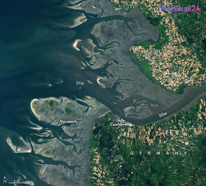
The Elbe River, a massive artery stretching over 1,000 kilometers across Europe, culminates in a dramatic display of natural power at its mouth in the North Sea. This region is defined by its mesotidal environment, where the rise and fall of the ocean constantly reshape the landscape. Satellite imagery reveals the stark contrast between high and low tide, highlighting a complex network of sandbars, mudflats, and deep-water channels that define the estuary’s geography.
These intertidal zones are part of the Wadden Sea, the world’s largest continuous system of its kind, serving as a critical habitat for over 10 million migratory birds annually. However, the area is also a vital economic corridor. The Elbe provides essential access to major shipping hubs, including the Port of Hamburg, the third-largest container port in the European Union. Maintaining this route requires constant dredging to manage sediment accumulation, as the asymmetrical nature of the tides—where incoming currents are faster and more sediment-heavy than outgoing ones—constantly threatens to obstruct navigation.
Beyond its ecological and commercial importance, the region faces significant challenges from extreme weather. Historical data shows that storm surges can push water levels well beyond typical tidal ranges, leading to severe coastal flooding. With sea levels rising at a rate of approximately 2.12 millimeters per year in the area, researchers are increasingly relying on advanced satellite technology, such as the SWOT and NISAR missions, to better model tidal behavior and improve flood protection strategies for the communities and infrastructure situated along the coast.
Key Takeaways
- The Elbe estuary is a vital economic gateway for European shipping, requiring constant maintenance to keep channels clear of sediment.
- The region is part of the Wadden Sea, a globally significant intertidal ecosystem that supports millions of migratory birds.
- Rising sea levels and the threat of extreme storm surges are driving new research into satellite-based tidal modeling and flood mitigation.
Editor’s Analysis & Impact
The Elbe estuary serves as a microcosm for the broader conflict between industrial necessity and environmental preservation in coastal regions. As one of Europe’s most critical maritime gateways, the economic pressure to maintain deep-water access for container shipping is immense, yet this must be balanced against the ecological fragility of the Wadden Sea. The future outlook for this region is heavily tied to climate adaptation; as sea levels rise, the cost of dredging and the risk of catastrophic storm surges will likely increase. The integration of high-resolution satellite data from missions like SWOT and NISAR represents a significant leap forward in predictive modeling. This technology will be essential for policymakers to design resilient infrastructure that can withstand the dual pressures of global trade demands and the accelerating impacts of climate change.
Frequently Asked Questions
Q: Why is the Elbe estuary important for shipping?
A: The Elbe provides essential access to major European ports, including Hamburg, which is the third-largest container port in the European Union, and serves as a gateway to the Kiel Canal.
Q: What makes the tides at the mouth of the Elbe unique?
A: The tides are asymmetrical, meaning the flood period is shorter than the ebb. This causes the incoming current to move faster and carry more sediment into the estuary than it carries out.
AI Disclosure: This article is based on verified data and official reports. Our Team and AI have cross-referenced every financial detail with primary sources to ensure total accuracy.
More from this Category