The Fire-Breathing Dragon: How Pyrocumulonimbus Clouds Are Escalating Wildfire Crises
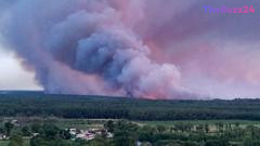
France is currently grappling with a dangerous and rare meteorological phenomenon as wildfires in the Gironde region have triggered the formation of pyrocumulonimbus clouds. Often described as fire-generated thunderstorms, these massive clouds are fueled by the intense heat of the blazes, which forces smoke, ash, and water vapor to rise rapidly into the atmosphere. As this air cools, it condenses into towering cumulonimbus structures that can generate their own erratic winds and lightning, significantly complicating containment efforts.
These fire clouds create a feedback loop that makes wildfires exponentially more unpredictable. The turbulent winds associated with these formations can scatter burning embers far ahead of the main fire front, while lightning strikes from the clouds can ignite new, secondary blazes. Authorities in France have noted that this is an unprecedented occurrence for the region, which is already struggling under the weight of record-breaking heatwaves and prolonged dry conditions that have left the landscape highly susceptible to combustion.
Experts warn that the situation in Gironde may persist for weeks, if not months, as further heatwaves threaten to push temperatures toward 40C. The emergence of pyrocumulonimbus clouds is increasingly linked to climate change, which creates the extreme heat and atmospheric instability necessary for their development. Similar catastrophic events have been documented in recent years during Australia’s 2019-2020 bushfires and California’s 2021 wildfire season, both of which demonstrated the devastating capacity of these ‘fire-breathing’ clouds to turn manageable fires into uncontrollable disasters.
Key Takeaways
- Pyrocumulonimbus clouds are fire-generated thunderstorms that create their own weather, including erratic winds and lightning.
- These clouds make wildfires significantly harder to contain by spreading embers over vast distances and sparking new fires.
- Climate change is increasing the frequency of these extreme events by creating the high-heat, low-moisture conditions required for their formation.
Editor’s Analysis & Impact
The emergence of pyrocumulonimbus clouds represents a critical shift in wildfire behavior, moving from standard forest management challenges to complex meteorological events. As global temperatures rise, the frequency of these ‘fire-breathing’ clouds is expected to increase, rendering traditional firefighting tactics less effective. This shift necessitates a fundamental change in emergency management and urban planning, as the unpredictability of these storms makes evacuation zones and containment lines obsolete almost instantly. Economically, the long-term impact of these mega-fires—ranging from the destruction of natural resources to the massive costs of prolonged suppression efforts—will likely strain national budgets and insurance markets. Future outlooks suggest that unless global climate trends are mitigated, regions previously considered low-risk will face increasing threats from these self-sustaining, extreme weather systems.
Frequently Asked Questions
Q: What exactly is a pyrocumulonimbus cloud?
A: It is a cloud formed by the intense heat of a wildfire. The fire acts as a chimney, pushing smoke and moisture high into the atmosphere, where it condenses into a thunderstorm-like cloud that can produce its own wind and lightning.
Q: Why do these clouds make wildfires more dangerous?
A: They create unpredictable, turbulent winds that can carry burning embers miles ahead of the fire front, and they can produce lightning strikes that ignite new fires, making the blaze nearly impossible to predict or contain.
AI Disclosure: This article is based on verified data and official reports. Our Team and AI have cross-referenced every financial detail with primary sources to ensure total accuracy.
More from this Category