New Satellite Mission Reveals Dramatic Land Subsidence in Mexico City
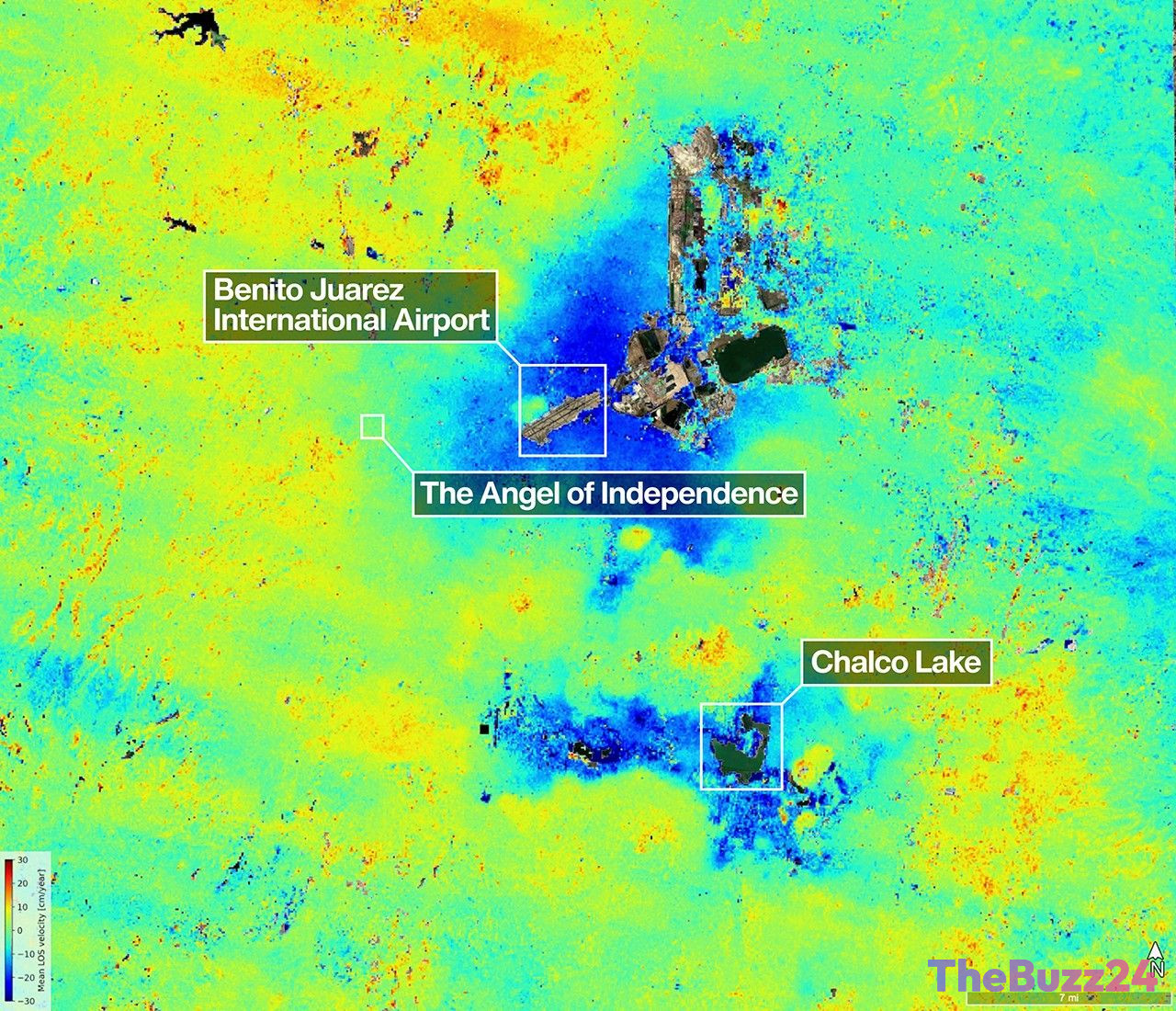
The NISAR (NASA-ISRO Synthetic Aperture Radar) mission has successfully captured high-resolution data revealing significant land subsidence across Mexico City. Observations collected between late 2025 and early 2026 highlight areas sinking by more than half an inch per month, a phenomenon largely attributed to intensive groundwater extraction that has compacted the city’s ancient lakebed foundation.
The satellite imagery provides a clear view of the urban landscape, including landmarks like the Angel of Independence. This monument, which has required the addition of 14 steps to its base over the last century to compensate for the sinking ground, serves as a stark physical reminder of the city’s ongoing geological challenges. The data also maps critical ecological zones, such as the Nabor Carrillo artificial lake and the historic Chalco Lake region, which once served as a primary habitat for the endangered Mexican Axolotl.
NISAR represents a technological milestone as the first satellite to carry two distinct Synthetic Aperture Radar instruments. By utilizing both L-band and S-band radar, the mission can penetrate dense vegetation and monitor diverse ecosystems with unprecedented precision. This dual-instrument approach allows researchers to track surface changes ranging from urban infrastructure shifts to glacial movements and agricultural health.
Beyond monitoring long-term geological trends, the mission is designed to provide rapid, global coverage to assist in disaster response and mitigation. By offering before-and-after observations of catastrophic events, the satellite provides essential data that will help scientists and policymakers better understand and react to environmental changes across the planet.
Key Takeaways
- The NISAR satellite mission has confirmed significant land subsidence in Mexico City, with some areas sinking over half an inch per month due to groundwater extraction.
- The mission utilizes a unique dual-radar system (L-band and S-band) to monitor surface changes, vegetation, and urban infrastructure with high precision.
- Data from the mission is intended to support global disaster response efforts by providing rapid, high-resolution observations of environmental and geological changes.
Editor’s Analysis & Impact
The successful deployment of the NISAR mission marks a significant advancement in Earth observation technology. By combining the capabilities of two different radar wavelengths, the mission provides a level of granularity that was previously difficult to achieve, particularly in complex urban environments like Mexico City. From a market and industry perspective, this highlights the growing importance of ‘Space-as-a-Service’ and the critical role of satellite data in urban planning, climate risk assessment, and infrastructure management. As land subsidence becomes a more pressing issue for global megacities, the ability to monitor these shifts in real-time will become an essential tool for civil engineering and disaster mitigation sectors. The future outlook suggests that such high-fidelity data will drive new standards in environmental policy and sustainable urban development, potentially creating new markets for predictive analytics and risk management software.
Frequently Asked Questions
Q: What is causing Mexico City to sink?
A: The primary cause of land subsidence in Mexico City is the extensive pumping of groundwater, which leads to the compaction of the dry, ancient lakebed upon which the city was constructed.
Q: What makes the NISAR satellite unique?
A: NISAR is the first satellite to carry two different Synthetic Aperture Radar (SAR) instruments—an L-band radar and an S-band radar—allowing it to monitor a wide variety of surfaces, from dense forests to grasslands, with high sensitivity.
AI Disclosure: This article is based on verified data and official reports. Our Team and AI have cross-referenced every financial detail with primary sources to ensure total accuracy.
More from this Category