The LAGEOS Satellite: A Timeless Beacon for Earth Science
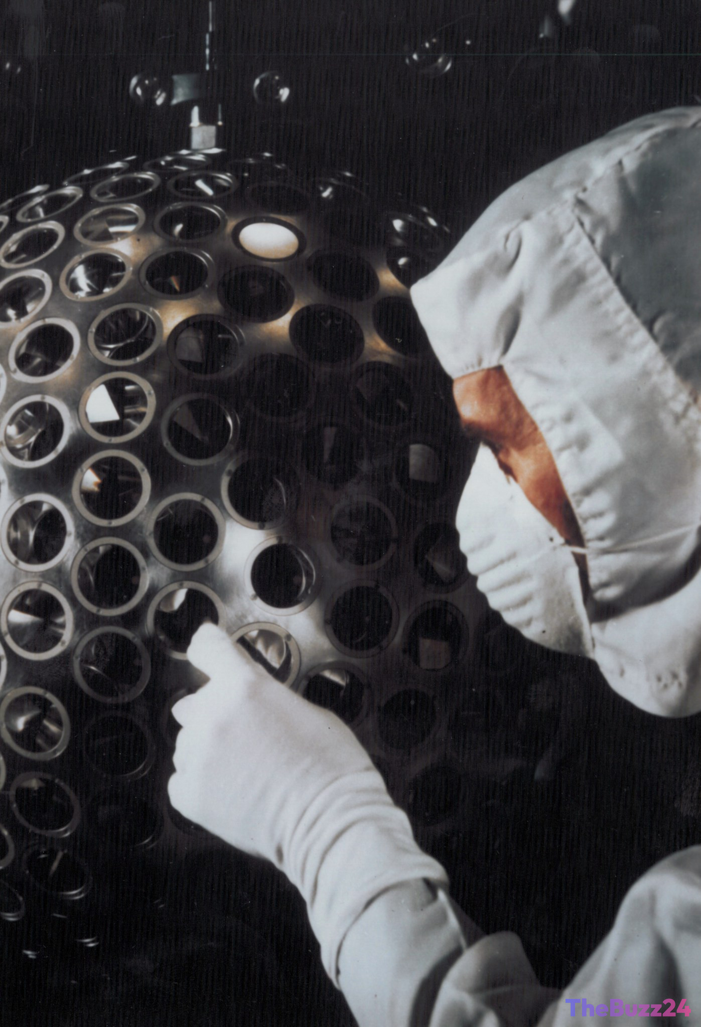
Launched in 1976, the Laser Geodynamics Satellite (LAGEOS) remains one of the most enduring achievements in space exploration. Designed with a minimalist philosophy, the satellite is a dense, two-foot-wide sphere weighing 900 pounds. Its exterior is covered in 426 specialized retroreflectors, which function as prisms to bounce laser pulses back to their source on Earth. This unique configuration allows ground-based observatories to determine the satellite’s position with incredible millimeter-level precision.
The core mission of LAGEOS was to establish a stable, reliable reference point in orbit. By tracking the precise travel time of laser pulses, researchers have gained invaluable insights into the movement of Earth’s tectonic plates. This data has been vital for mapping fault lines, refining global gravity models, and providing empirical evidence to support Einstein’s theory of general relativity. The program was further strengthened in 1992 with the addition of LAGEOS II, a joint project that enhanced the consistency and scope of these geodetic measurements.
Unlike modern satellites that rely on complex electronics and power systems, LAGEOS is a passive object. Its high orbital altitude and lack of onboard components minimize atmospheric drag, ensuring it remains a permanent fixture in space. Because it requires no maintenance or fuel, the satellite is expected to orbit the Earth for millions of years, serving as a long-term benchmark for future generations of scientists to monitor the evolving dynamics of our planet.
Key Takeaways
- LAGEOS utilizes 426 retroreflectors to enable ground stations to measure its orbital distance with millimeter-level accuracy.
- The satellite has provided decades of essential data regarding tectonic plate shifts, gravity models, and general relativity.
- Due to its passive, durable design and high altitude, LAGEOS is projected to remain in orbit for millions of years.
Editor’s Analysis & Impact
The LAGEOS mission serves as a definitive case study in the value of long-term scientific infrastructure. In an industry currently dominated by rapid technological turnover and complex, power-dependent hardware, LAGEOS demonstrates that passive, robust engineering can yield superior, consistent data over decades. By establishing a permanent reference point, the mission has facilitated a multi-generational study of Earth’s crustal dynamics that would be unattainable with shorter-lived assets. The broader implication for the aerospace sector is a reminder that simplicity often correlates with extreme reliability. As humanity looks toward future planetary monitoring, the LAGEOS model provides a blueprint for creating ‘eternal’ scientific infrastructure that can outlast the organizations that created it, ensuring a continuous stream of data for centuries to come.
Frequently Asked Questions
Q: Why is the LAGEOS satellite often compared to a disco ball?
A: The satellite's surface is embedded with 426 retroreflectors, which are specialized prisms designed to reflect laser beams back to their origin. This faceted, reflective exterior gives it the appearance of a metallic disco ball.
Q: How long is the LAGEOS satellite expected to remain in orbit?
A: Because LAGEOS is a passive object with no complex electronics or propulsion systems, and it orbits at a high altitude with minimal atmospheric drag, it is expected to remain in orbit for millions of years.
AI Disclosure: This article is based on verified data and official reports. Our Team and AI have cross-referenced every financial detail with primary sources to ensure total accuracy.
More from this Category