Satellite Radar Breakthrough Revolutionizes Crop Monitoring in South Africa’s Maize Triangle
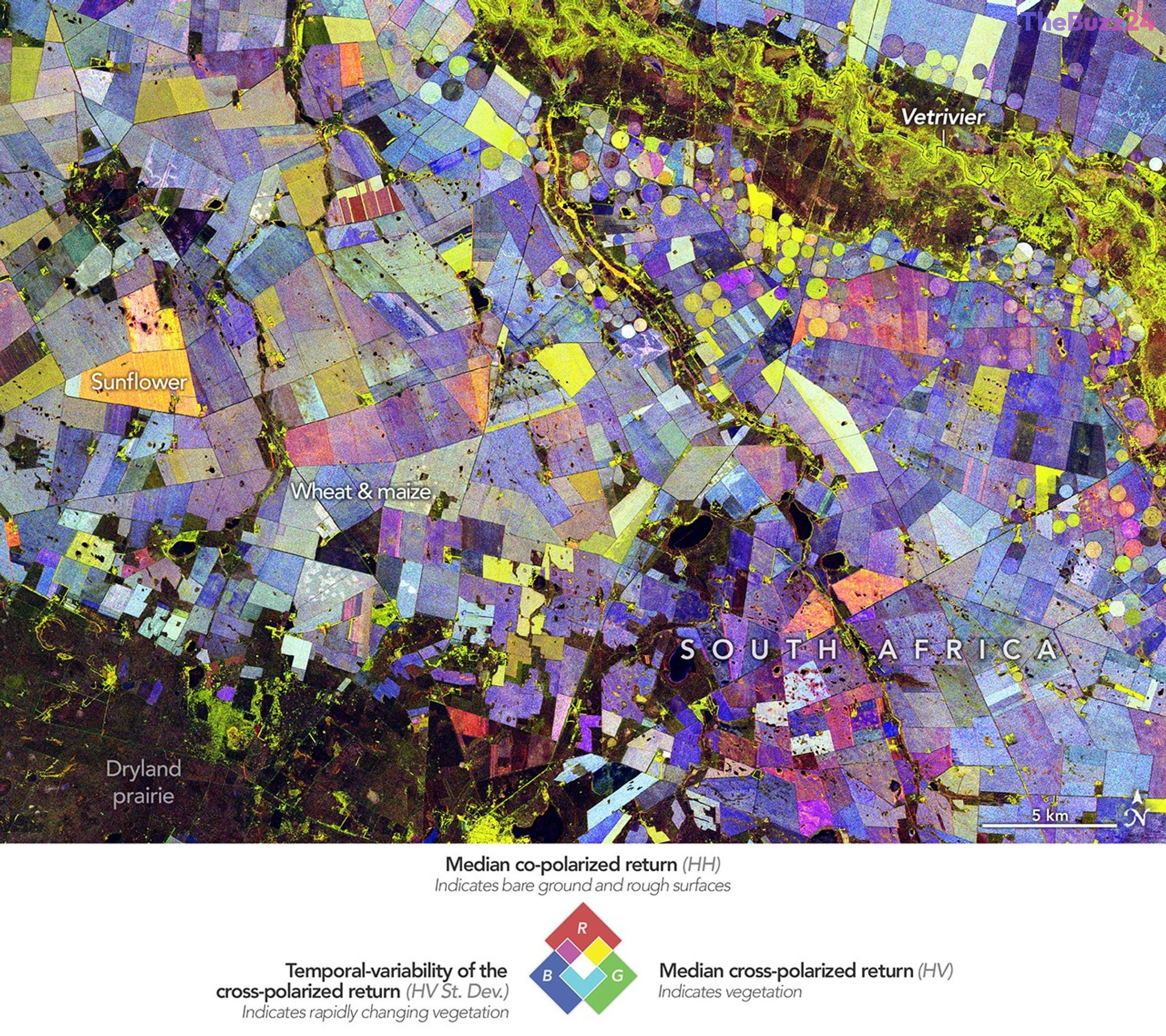
Advanced satellite radar technology is providing an unprecedented look at the agricultural dynamics within South Africa’s Free State province. By leveraging data from the NASA-ISRO Synthetic Aperture Radar (NISAR) mission, researchers have successfully mapped the region’s growing season, transforming complex radar signals into high-resolution visualizations that track crop development throughout the 2025-2026 cycle.
The mapping process utilizes a sophisticated false-color scheme to categorize land use and vegetation health. In these images, green highlights established vegetation, red marks barren or unvegetated surfaces, and blue tracks the velocity of vegetation change. This granular level of detail allows scientists to distinguish between permanent forest cover and the rapid growth cycles of essential crops like maize and wheat, providing a clear view of agricultural productivity near the Vet River.
Unlike traditional optical imagery, which can be obscured by cloud cover, radar technology measures how signals bounce off the Earth’s surface. The orientation of these returned waves provides specific data regarding plant structure and growth stages. For example, sunflowers display unique radar signatures that enable researchers to monitor their progress from initial planting to final harvest. This capability offers a repeatable and highly accurate method for observing field-to-field variations across expansive agricultural zones.
As data collection continues, this analytical framework is poised to become a vital tool for understanding how agricultural systems adapt to climate variability and evolving irrigation practices. By analyzing seasonal trends, experts aim to gain a deeper understanding of land-use shifts and the overall ecological health of the Maize Triangle, ultimately helping to secure food production in an increasingly unpredictable climate.
Key Takeaways
- The NISAR satellite mission is utilizing advanced radar to map crop growth cycles in South Africa's Free State province with high precision.
- Radar technology allows for the differentiation of crop types and vegetation health by measuring signal reflections, even in challenging weather conditions.
- The data collected is critical for monitoring how agricultural landscapes respond to climate change, water usage, and evolving irrigation techniques.
Editor’s Analysis & Impact
The deployment of NISAR-based radar mapping represents a significant leap forward in precision agriculture. By moving beyond traditional optical satellite imagery, researchers can now penetrate cloud cover and gain structural insights into plant development that were previously invisible. This technology has profound implications for global food security, particularly in semi-arid regions where water management is critical. As climate patterns become more volatile, the ability to monitor crop health and land-use changes in real-time will allow governments and agricultural firms to make data-driven decisions regarding resource allocation and drought mitigation. The future outlook suggests that such high-resolution monitoring will become a standard requirement for sustainable farming, potentially reducing waste and increasing yields by identifying stress points in crops long before they are visible to the naked eye.
Frequently Asked Questions
Q: How does radar imagery differ from standard satellite photos?
A: Standard satellite photos rely on visible light, which can be blocked by clouds. Radar imagery sends signals to the ground and measures the bounce-back, allowing it to see through clouds and provide data on the physical structure of crops.
Q: Why is this technology important for the Maize Triangle?
A: The Maize Triangle is a vital agricultural hub. This technology helps monitor water usage and crop health, which is essential for maintaining productivity in a semi-arid region prone to climate variability.
AI Disclosure: This article is based on verified data and official reports. Our Team and AI have cross-referenced every financial detail with primary sources to ensure total accuracy.
More from this Category